Kuala Krai District

Last updated

Kuala Krai District
Jajahan Kuala Krai
Flag of Kuala Krai, Kelantan.svg
Shield of Kuala Krai.png
Kuala Krai highlighted in Kelantan, Malaysia.svg
Location of Kuala Krai District in Kelantan
Kuala Krai District
Malaysia location map with districts.svg
Red pog.svg
Kuala Krai District
Location of Kuala Krai District in Malaysia
Coordinates: 5°30′N102°10′E / 5.500°N 102.167°E / 5.500; 102.167
Country Flag of Malaysia 23px.svg  Malaysia
State Flag of Kelantan.svg  Kelantan
Seat Kuala Krai
Local area government(s) Kuala Krai District Council (North Kuala Krai)
Dabong District Council (South Kuala Krai)
Government
  District officerHaji Tengku Ab Rahman bin Tuan Yunus [1]
  Administrative office Kuala Krai Land Officers and Colony
Area
[2]
  Total
2,275 km2 (878 sq mi)
Population
 (2021) [3]
  Total
105,900
  Density47/km2 (120/sq mi)
Time zone UTC+8 (MST)
  Summer (DST) UTC+8 (Not observed)
Postcode
18xxx
Calling code +6-09-9
Vehicle registration plates D
Kuala Krai KualaKrai2005.jpg
Kuala Krai

Kuala Krai District (Kelantanese: Jajahey Kkeghe) is a district (jajahan) in Kelantan, Malaysia. Historically, it was known as Kuala Lebir. [4]

Contents

Background

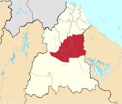
The Kuala Krai district is a landlocked district in the centre of the State of Kelantan in northeastern Malaysia. The land is hilly, and before the 20th century the entire area was tropical rain forest. The territory contains the confluence of two major rivers, the Lebir and Galas, to form the Kelantan River, which then flows some 70 km northwards through one of the most densely populated flood plains on the Malay Peninsula to its estuary in the South China Sea near the State capital of Kota Bharu.

Kuala Krai was the most affected district in Kelantan by a massive 2014 flood known as Bah Kuning that resulted in property loses and in the federal government declaring a State of Emergency. This catastrophic event was cushioned by great societal support and aid from NGOs.

As transport links improved during the 20th century, people moved into the area to take advantage of the abundant land available for farming. A railway was constructed in the 1920s through the undeveloped interior of Malaysia to link Kelantan State with the main centres of population on the west coast. This line ran through Kuala Krai territory, and settlements became established along the route. Road links followed, and towns and villages grew to house the mainly agricultural population. Rubber production was becoming increasingly important throughout Malaysia at the time, and many rubber-tree plantations were set up in this area. Later, the country-wide shift to oil palm in the 1970s and 1980s saw the establishment of oil palm plantations in the territory, some of which replaced rubber.

Kuala Krai was originally part of Ulu Kelantan until it was split following a re-delineation in 1974. Kuala Krai formally gained its own district and municipal administration in 1977. [5]

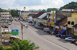
Infrastructure developed to support the population, and by the end of the 20th century Kuala Krai town had become a busy, thriving town as well as the administrative centre for the territory.

Demographics

Historical population
YearPop.±%
1991 90,830    
2000 91,771+1.0%
2010 104,234+13.6%
2020 105,007+0.7%
Source: [6]

Kuala Krai District has an area of 2329 km² and comprises three subdistricts (daerah): [2]

Some of the better known towns and villages in the territory include Dabong, Kemubu, Manek Urai, Kampung Pahi, Kampung Peria and Kampung Laloh.

Secondary schools

The secondary schools in the territory are: [7]

Population

Map of Kuala Krai District Map of Kuala Krai District, Kelantan.svg
Map of Kuala Krai District

The population of Kuala Krai territory was 117,800 in 2009.

Ranking Population Jajahan Kuala Krai.

RankDaerah/MukimPopulation 2000PBT Council
1Batu Mengkebang55,975Kuala Krai District Council
2Olak Jeram24,665Dabong District Council
3 Dabong 11,131Dabong District Council

Population ethnicity

The population and ethnicity of the territory is as follows: [2]

Population of the territory – breakdown by race
Race1990%1995%2000%2004%
Malay92,91691.4110,24690.9130,81090.9149,01890.8
Chinese5,6855.67,2826.08,6576.09,8626.0
Indian2,6502.63,3642.73,9902.84,5452.7
Other3540.4121,3390.44630.35270.3

Attractions

Famous people from Kuala Krai

Federal Parliament and State Assembly Seats


List of LMS district representatives in the Federal Parliament (Dewan Rakyat)

ParliamentSeat NameMember of ParliamentParty
P31 Kuala Krai Abdul Latiff Abdul Rahman PN (PAS)


List of LMS district representatives in the State Legislative Assembly of Kelantan

ParliamentStateSeat NameState AssemblymanParty
P31N39 Mengkebang Muhammad Mat Sulaiman PN (PAS)
P31N40 Guchil Hilmi Abdullah PN (PAS)
P31N41 Manek Urai Mohd Fauzi Abdullah PN (PAS)
P31N42 Dabong Ku Mohd Zaki Ku Hussin PN (PAS)

See also

References

  1. "Pejabat Tanah Dan Jajahan Kuala Krai - Perutusan Ketua Jajahan". www.ptjkk.kelantan.gov.my. Retrieved 9 September 2022.
  2. 1 2 3 "Profail Jajahan Kuala Krai". Pejabat Tanah dan Jajahan Kuala Krai. Archived from the original on 12 March 2008. Retrieved 23 October 2007.
  3. "Population Distribution and Basic Demographic Characteristics, 2010" (PDF). Department of Statistics, Malaysia. Archived from the original (PDF) on 22 May 2014. Retrieved 19 April 2012.
  4. "Map of British Malaya Including The Straits Settlements Federated Malay States and Malay States Not Included In The Federation 1924" (JPG). Raremaps.com. Retrieved 26 April 2016.
  5. "Info Kuala Krai". Majlis Daerah Kuala Krai. Retrieved 10 January 2017.
  6. "Key Findings of Population and Housing Census of Malaysia 2020" (pdf) (in Malay and English). Department of Statistics, Malaysia. ISBN   978-967-2000-85-3.
  7. "Secondary Schools in Kelantan, Malaysia". Jadn.com. 2007. Retrieved 6 December 2007.
  8. Perpustakaan Negara Malaysia (2003). "Yang di-Pertuan Agong III". Malaysian Monarchy. Archived from the original on 27 October 2005. Retrieved 10 December 2006.