Kota Setar District

Last updated
Kota Setar District
Daerah Kota Setar
Other transcription(s)
   Jawi كوتا ستار
   Chinese 哥打士打县
   Tamil கோத்தா ஸ்டார்
Kota Setar highlighted in Kedah, Malaysia.svg
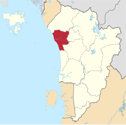
Location of Kota Setar District in Kedah
Kota Setar District
Malaysia location map with districts.svg
Red pog.svg
Kota Setar District
Location of Kota Setar District in Malaysia
Coordinates: 6°5′N100°20′E / 6.083°N 100.333°E / 6.083; 100.333
Country Flag of Malaysia.svg  Malaysia
State Flag of Kedah.svg  Kedah
Seat Alor Setar
Local area government(s) Alor Setar City Council
Government
  District officerAbdullah Hashim
Area
[1]
  Total422.99 km2 (163.32 sq mi)
Population
 (2010) [2]
  Total360,129
  Density850/km2 (2,200/sq mi)
Time zone UTC+8 (MST)
  Summer (DST) UTC+8 (Not observed)
Postcode
05xxx
Calling code +6-04
Vehicle registration plates K

The Kota Setar District is a district in Kedah, Malaysia where the state capital Alor Star is situated. [3]

Contents

Name

The name Kota Setar came from the Setar or ‘Stak’ tree (Bouea macrophylla), an indigenous plant that bore an edible orange coloured fruit.

Administrative divisions

Map of Kota Setar District Map of Kota Setar District, Kedah.svg
Map of Kota Setar District
Kota Setar District and Land Office Kota Setar District and Land Office.jpg
Kota Setar District and Land Office

Kota Setar District is divided into 28 mukims, which are:

  1. Alor Malai
  2. Alor Merah
  3. Anak Bukit
  4. Bukit Pinang
  5. Derga
  6. Gunong
  7. Hutan Kampung
  8. Kangkong
  9. Kota Setar
  10. Kuala Kedah
  11. Kubang Rotan
  12. Langgar
  13. Lengkuas
  14. Lepai
  15. Limbong
  16. Mergong
  17. Padang Hang
  18. Padang Lalang
  19. Pengkalan Kundor
  20. Pumpong
  21. Sala Kechil
  22. Sungai Baharu
  23. Tajar
  24. Tebengau
  25. Telaga Mas
  26. Telok Chengai
  27. Telok Kechai
  28. Titi Gajah

Demographics

Historical population
YearPop.±%
1991 322,354    
2000 354,513+10.0%
2010 357,176+0.8%
2020 374,051+4.7%
Figures before 2009 includes Pokok Sena District.
Source: [4]

Federal Parliament and State Assembly Seats


List of Kota Setar district representatives in the Federal Parliament (Dewan Rakyat)

ParliamentSeat NameMember of ParliamentParty
P8 Pokok Sena Ahmad YahyaPerikatan Nasional (PAS)
P9 Alor Setar Afnan Hamimi Taib AzammudinPerikatan Nasional (PAS)
P10 Kuala Kedah Ahmad Fakhruddin FakhurraziPerikatan Nasional (PAS)


List of Kota Setar district representatives in the State Legislative Assembly of Kedah

ParliamentStateSeat NameState AssemblymanParty
P8N9 Bukit Lada Salim Mahmood Al-Hafiz Perikatan Nasional (PAS)
P8N10 Bukit Pinang Romani Wan Salim Perikatan Nasional (PAS)
P8N11 Derga Muhammad Amri WahabPerikatan Nasional (BERSATU)
P9N12 Suka Menanti Dzowahir Ab GhaniPerikatan Nasional (BERSATU)
P9N13 Kota Darul Aman Teh Swee Leong Pakatan Harapan (DAP)
P9N14 Alor Mengkudu Muhamad Radhi Mat Din Perikatan Nasional (PAS)
P10N15 Anak Bukit Rashidi Abdul RazakPerikatan Nasional (PAS)
P10N16 Kubang Rotan Mohd Salleh SaidinPerikatan Nasional (BERSATU)
P10N17 Pengkalan Kundor Mardhiyyah JohariPerikatan Nasional (PAS)

Related Research Articles

<span class="mw-page-title-main">Perlis</span> State of Malaysia

Perlis, also known by its honorific title Perlis Indera Kayangan, is a state of Malaysia in the northwestern coast of Peninsular Malaysia. It is the smallest state in Malaysia by means of area and population, as well as the northernmost in the country. The state borders the Thai provinces of Satun and Songkhla to the north and the Malaysian state of Kedah to the south. Perlis is the only Malaysian state that is not divided into any districts, due to its small size, but it is still divided into several communes. It was called Palit by the Siamese when it was under their influence. Perlis had a population of 227,025 as of the 2010 census.

<span class="mw-page-title-main">Kedah</span> State of Malaysia

Kedah, also known by its honorific Darul Aman and historically as Queda, is a state of Malaysia, located in the northwestern part of Peninsular Malaysia. The state covers a total area of over 9,000 km2, and it consists of the mainland and the Langkawi islands. The mainland has a relatively flat terrain, which is used to grow rice, while Langkawi is an archipelago, most of which are uninhabited islands.

<span class="mw-page-title-main">Sungai Petani</span> Town and district capital in Kedah, Malaysia

Sungai Petani is a town in Kuala Muda District, Kedah, Malaysia. Sungai Petani is Kedah's largest city and is located about 55 km south of Alor Setar, the capital of Kedah, and 33 km northeast of George Town, the capital city of the neighbouring state of Penang.

<span class="mw-page-title-main">Alor Setar</span> State capital of Kedah, Malaysia

Alor Setar is the state capital of Kedah, Malaysia. It is the second-largest city in the state after Sungai Petani and one of the most-important cities on the west coast of Peninsular Malaysia. It is home to the third-tallest telecommunication tower in Malaysia, the Alor Setar Tower.

<span class="mw-page-title-main">Baling District</span> District of Malaysia in Kedah

The Baling District is an administrative district in southeastern Kedah, Malaysia. Located about 110 km from Alor Setar, it borders Perak and Betong, the southernmost town of Thailand.

<span class="mw-page-title-main">Hulu Perak District</span> District of Malaysia in Perak

Hulu Perak District is a district in Perak, Malaysia. As the largest district in Perak, there are border to the east of the district is the state of Kelantan, to the west is Kedah, to the south is the district of Kuala Kangsar while to the south-west is the district of Larut, Matang and Selama. Hulu Perak also shares a border with Betong District of Thailand. The seat of the district is Gerik, which is also the largest town of the district.

<span class="mw-page-title-main">Bandar Baharu District</span> District of Malaysia in Kedah

The Bandar Baharu District is a town, district and state assembly constituency at the southernmost end of Kedah, Malaysia. Bandar Baharu is located along the Kedah-Penang–Perak border tripoint, 37 km (23 mi) southeast of George Town, Penang's capital city.

<span class="mw-page-title-main">Pendang District</span> District of Malaysia in Kedah

The Pendang District is a town, a district and a parliamentary constituency in Kedah, Malaysia. The district is primarily covered with paddy fields with agriculture being its main economic activity. Pendang town is about 20 km from state capital Alor Setar.

<span class="mw-page-title-main">Sik District</span> District of Malaysia in Kedah

Sik District is a district in Kedah, Malaysia. It is largest district in Kedah.

<span class="mw-page-title-main">Yan District</span> District of Malaysia in Kedah

The Yan District is a district in Kedah, Malaysia. It is bordered by Kota Setar District to the north, Pendang District to the northeast and Kuala Muda District to the south. Yan District is along the coast of the Straits of Malacca. It is the smallest municipality in Kedah.

<span class="mw-page-title-main">Anak Bukit</span> Town in Kedah, Malaysia

Anak Bukit is a mukim and the royal town of Kedah, Malaysia, located in Kota Setar District and falls under the jurisdiction of the Alor Setar City Council.

<span class="mw-page-title-main">Pokok Sena District</span> District of Malaysia in Kedah

The Pokok Sena District is a district and parliamentary constituency in Kedah, Malaysia. It is the 12th district of Kedah which was formerly a subdistrict of Kota Setar, about 20 km east of Alor Setar. The declaration of the 24,000ha district with a population of 50,000 was made by the Sultan of Kedah, Tuanku Abdul Halim Mu'adzam Shah in conjunction with his 81st birthday celebrations in January 2009. The district is divided into 6 sub-districts: Gajah Mati, Jabi, Tualang, Lesong, Bukit Lada, Derang and consists of 122 villages and 21 residential areas. The Pokok Sena district lies within the boundaries of the Alor Setar City Council local government area authority.

<span class="mw-page-title-main">Padang Terap District</span> District of Malaysia in Kedah

The Padang Terap District is a district in Kedah, Malaysia. It is governed by the Padang Terap District Council. Padang Terap District shares a border with Thailand to the north, and with Sik District and Pendang District to the west. It is the third largest district in the State of Kedah, with Kuala Nerang serving as its administrative center.

<span class="mw-page-title-main">Kuala Muda District</span> District in Kedah, Malaysia

The Kuala Muda District is a district in Kedah, Malaysia. Sungai Petani is the administrative center of the district. Kuala Muda district is in close proximity to the border of Kedah and Penang. Apart from Sungai Petani, other major towns in the district include Tikam Batu, Padang Tembusu, Sungai Lalang, Bedong, Bukit Selambau, Sidam, Gurun, Semeling, Merbok, Kota Kuala Muda and Tanjung Dawai. The Mount Jerai is shared with the neighbouring district of Yan while the Muda River is shares the bordering state of Penang. The iconic Jambatan Merdeka connect both Tikam Batu with Bumbung Lima in Penang. Kuala Muda is the second largest and most populous district in Kedah, and it is also the site of some of the earliest civilization site in the country.

<span class="mw-page-title-main">Kubang Pasu District</span> District of Malaysia in Kedah

The Kubang Pasu District is a district in northern Kedah, Malaysia. It contains the border town of Bukit Kayu Hitam as well as the educational hub of Changlun, while Jitra is the largest town and administrative centre of the district. The district council had been upgraded into municipal council on 22 October 2018, becoming the fifth city or municipal in the state.

<span class="mw-page-title-main">Sultan Abdul Halim Airport</span> Airport in Kedah, Malaysia

Sultan Abdul Halim Airport is an airport in Kepala Batas, Kedah, Malaysia. It serves the city of Alor Setar and the state of Perlis due to the state's small geographical size.

<span class="mw-page-title-main">Central Seberang Perai District</span> District of Malaysia in Penang

The Central Seberang Perai District is a district in the state of Penang, Malaysia. It covers an area of 238 square kilometres, and had a population of 371,975 at the 2010 Census. The district is bordered by Perai River which separates North Seberang Perai in the north, Junjong River which separates South Seberang Perai in the south, Kedah state border in the east and South Channel which separates Penang Island. Juru River also flows through the district. The capital of this district is Bukit Mertajam. Other localities in Central Seberang Perai include Permatang Pauh, Penanti, Bukit Tengah, Bukit Minyak, Juru, Alma, Machang Bubok and Permatang Tinggi. The entertainment, eatery and automobile venue of Autocity is also located in this district. Heavy industrial areas cover most parts of Central Seberang Perai.

<span class="mw-page-title-main">Kulim District</span> District of Malaysia in Kedah

The Kulim District is a district and town in the state of Kedah, Malaysia. It is located on the southeast of Kedah, bordering Penang. The town of Kulim, a mere 27 km (17 mi) east of Penang's capital city, George Town, also forms part of Greater Penang, Malaysia's second largest conurbation.

<span class="mw-page-title-main">Bukit Pinang</span>

Bukit Pinang is a mukim in Kota Setar District, Kedah, Malaysia. It was once the seat of the Sultanate of Kedah and its annexed territories. Bukit Pinang is also the current name for the State of Kedah Legislative Assembly seat which is also located in the Parliamentary seat of Pokok Sena.

<span class="mw-page-title-main">Alor Setar (federal constituency)</span> Federal constituency of Kedah, Malaysia

Alor Setar is a federal constituency in Kota Setar District, Kedah, Malaysia, that has been represented in the Dewan Rakyat since 1955.

References

  1. "Laman Web Rasmi Pejabat Daerah Kota Setar - Sejarah Pentadbiran". pdks.kedah.gov.my. Archived from the original on 2017-12-13. Retrieved 2017-11-26.
  2. "Population Distribution and Basic Demographic Characteristics, 2010" (PDF). Department of Statistics, Malaysia. Archived from the original (PDF) on 22 May 2014. Retrieved 19 April 2012.
  3. http://apps.water.gov.my/jpskomuniti/dokumen/DEEP_KOTA%20SETAR_APRIL2011.pdf Archived 2017-03-26 at the Wayback Machine [ bare URL PDF ]
  4. "Key Findings of Population and Housing Census of Malaysia 2020" (pdf) (in Malay and English). Department of Statistics, Malaysia. ISBN   978-967-2000-85-3.