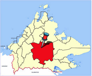
The Interior Division is an administrative division of the state of Sabah, Malaysia. It occupies the southwest portion of Sabah, bordered by the neighbouring state of Sarawak on its west. With an area of 18,298 square kilometres, it covers 24.9% of Sabah's territory and is home to approximately 14.7% of Sabah's total population. The largest town in the Interior Division is Keningau. Other main towns in this division include Beaufort, Kuala Penyu, Sipitang, Tambunan and Tenom.

Keningau is the capital of the Keningau District in the Interior Division of Sabah, Malaysia. It is the fifth-largest town in Sabah, as well one of the oldest. Keningau is between Tambunan and Tenom. The town had an estimated population of 173,130. Dusuns, Muruts and Lundayehs is the major ethnics in Keningau.

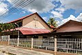
Tenom is the capital of the Tenom District in the Interior Division of Sabah, Malaysia. Its population was estimated to be around 5,148 in 2010. It is located about 176 kilometres south of Kota Kinabalu and 128 kilometres north of Long Pasia, which is one of the famous attractions in Sabah. In the early days of British colonial rule in Malaysia, the town was called Fort Birch. The town is considered the unofficial capital of the Murut community, whose most important festival, the annual Pesta Kalimaran, is held in the town. It is also the main gateway to other areas within the Murut heartland and the minority of Lundayeh.

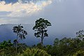
Tambunan is the capital of the Tambunan District in the Interior Division of Sabah, Malaysia. Its population was estimated to be around 35,667 in 2010. It is located 80 kilometres east of the state capital, Kota Kinabalu, 48 kilometres south of Ranau and 48 kilometres north of Keningau. At an average altitude of 750 metres, this valley town, which is part of the Crocker Range, experiences a mild tropical climate all year long. The valley is peppered with terraced paddy fields and 70 villages. The dense forests of bamboo around Tambunan town are a legacy of the British colonial period, during which an edict stated that 20 bamboo sprouts had to be planted for every bamboo cut.

The Murut, alternatively referred to as Tagol/Tahol, constitute an indigenous ethnic community comprising 29 distinct sub-ethnic groups dwelling within the northern inland territories of Borneo. Characterized by their rich cultural diversity, the Murutic languages form a linguistic family encompassing approximately half a dozen closely intertwined Austronesian languages. Murut populations exhibit dispersion in Malaysia's Sabah and the northern part of Sarawak, as well as in the country of Brunei and the Indonesian North Kalimantan Province. Furthermore, the Murut people have close connections with the Tidung, who historically inhabited Borneo's east coast region that underwent processes of Islamization and Malayalization,

Bingkor is a small township in Keningau District, Interior Division, Sabah, Malaysia. The majority of the population are Dusuns and Murut, which consists of part of the Borneo Dayak ethnic group. The Dusuns are divided into Dusun Gana and Dusun Kuyau, while the Murut is Nabai or Murut Keningau. Both these sub-Dusun families and the Murut people also represent the image of Keningau as a central district.

George Cathcart Woolley was a British colonial administrator in North Borneo in the early part on the twentieth century. Woolley was also an ethnographer and an ardent collector, and the Woolley Collections of photographs, diaries and other artefacts, bequeathed to the State Government of Sabah, formed the nucleus of Sabah Museum when it was founded in 1965.

Sedomon Gunsanad Kina MBE (1894-1966) was a native chief of Keningau, in North Borneo, who later became a politician in unified Malaysia. He was the son of Gunsanad Kina and the older brother of G.S Sundang.

Sabah is the third most populous state in Malaysia, with a population of 3,418,785 according to the 2020 Malaysian census. It also has the highest non-citizen population, at 810,443. Although Malaysia is one of the least densely populated countries in Asia, Sabah is particularly sparsely populated. Most of the population is concentrated along coastal areas, with towns and urban centres seeing the most population growth.
The Beaufort District is an administrative district in the Malaysian state of Sabah, part of the Interior Division which includes the districts of Beaufort, Keningau, Kuala Penyu, Nabawan, Sipitang, Tambunan and Tenom. The population of Beaufort is composed mainly of Bisaya, Brunei Malays, Kadazan-Dusuns, Lun Bawang/Lun Dayeh, Muruts and Chinese.

The Kuala Penyu District is an administrative district in the Malaysian state of Sabah, part of the Interior Division which includes the districts of Beaufort, Keningau, Kuala Penyu, Nabawan, Sipitang, Tambunan and Tenom. The capital of the district is in Kuala Penyu Town.

The Nabawan District is an administrative district in the Malaysian state of Sabah, part of the Interior Division which includes the districts of Beaufort, Keningau, Kuala Penyu, Nabawan, Sipitang, Tambunan and Tenom. The capital of the district is in Nabawan Town.

The Sipitang District is an administrative district in the Malaysian state of Sabah, part of the Interior Division which also includes the districts of Beaufort, Keningau, Kuala Penyu, Nabawan, Tambunan and Tenom. The capital of the district is in Sipitang Town. The ecotourism village of Long Mio and Long Pasia is located in this district, while the small town of Sindumin serves as a gateway to the state of Sarawak.

The Tambunan District is an administrative district in the Malaysian state of Sabah, part of the Interior Division which includes the districts of Beaufort, Keningau, Kuala Penyu, Nabawan, Sipitang, Tambunan and Tenom. The capital of the district is in Tambunan Town.

The Tenom District is an administrative district in the Malaysian state of Sabah, part of the Interior Division which includes the districts of Beaufort, Keningau, Kuala Penyu, Nabawan, Sipitang, Tambunan and Tenom. The capital of the district is in Tenom Town.Majority Tenom is Murut while Kadazandusun as well as Lundayeh are minorities in Tenom.

The Kudat District is an administrative district in the Malaysian state of Sabah, part of the Kudat Division which includes the districts of Kota Marudu, Kudat and Pitas. The capital of the district is in Kudat Town.

The Pitas District is an administrative district in the Malaysian state of Sabah, part of the Kudat Division which includes the districts of Kota Marudu, Kudat and Pitas. The capital of the district is in Pitas Town.

The Beluran District is an administrative district in the Malaysian state of Sabah, part of the Sandakan Division which includes the districts of Beluran, Kinabatangan, Sandakan, Telupid and Tongod. The capital of the district is in Beluran Town.
The Tongod District is an administrative district in the Malaysian state of Sabah, part of the Sandakan Division which includes the districts of Beluran, Kinabatangan, Sandakan, Telupid and Tongod. The capital of the district is in Tongod Town.

The Kota Kinabalu District is an administrative district in the Malaysian state of Sabah, part of the West Coast Division which includes the districts of Kota Belud, Kota Kinabalu, Papar, Penampang, Ranau and Tuaran. The capital of the district is in Kota Kinabalu City.