Climate is the long-term weather pattern in an area, typically averaged over 30 years. More rigorously, it is the mean and variability of meteorological variables over a time spanning from months to millions of years. Some of the meteorological variables that are commonly measured are temperature, humidity, atmospheric pressure, wind, and precipitation. In a broader sense, climate is the state of the components of the climate system, including the atmosphere, hydrosphere, cryosphere, lithosphere and biosphere and the interactions between them. The climate of a location is affected by its latitude/longitude, terrain, altitude, land use and nearby water bodies and their currents.

In geography, the temperate climates of Earth occur in the middle latitudes, which span between the tropics and the polar regions of Earth. These zones generally have wider temperature ranges throughout the year and more distinct seasonal changes compared to tropical climates, where such variations are often small and usually only have precipitation changes.

The Köppen climate classification is one of the most widely used climate classification systems. It was first published by German-Russian climatologist Wladimir Köppen (1846–1940) in 1884, with several later modifications by Köppen, notably in 1918 and 1936. Later, the climatologist Rudolf Geiger (1894–1981) introduced some changes to the classification system, which is thus sometimes called the Köppen–Geiger climate classification system.

An oceanic climate, also known as a marine climate, is the humid temperate climate sub-type in Köppen classification Cfb, typical of west coasts in higher middle latitudes of continents, generally featuring cool summers and mild winters, with a relatively narrow annual temperature range and few extremes of temperature. Oceanic climates can be found in both hemispheres generally between 45 and 63 latitude, most notably in Northwestern Europe, Northwestern America, as well as New Zealand.

A humid continental climate is a climatic region defined by Russo-German climatologist Wladimir Köppen in 1900, typified by four distinct seasons and large seasonal temperature differences, with warm to hot summers and freezing cold winters. Precipitation is usually distributed throughout the year but often do have dry seasons. The definition of this climate regarding temperature is as follows: the mean temperature of the coldest month must be below 0 °C (32.0 °F) or −3 °C (26.6 °F) depending on the isotherm, and there must be at least four months whose mean temperatures are at or above 10 °C (50 °F). In addition, the location in question must not be semi-arid or arid. The cooler Dfb, Dwb, and Dsb subtypes are also known as hemiboreal climates.

Sandakan Division is an administrative division of Sabah, Malaysia. It stretches diagonally from the northeastern coast of Sabah to the state's central region. With an area of 28,205 square kilometres, it occupies 38.3% of Sabah's territory, and is thus the largest of the five administrative divisions of Sabah. It also has approximately 19.4% of Sabah's total population, with the major inhabitants comprising the Chinese, Orang Sungai, Kadazan-Dusun, Suluk and Bajau Simunul.

In common usage, climate change describes global warming—the ongoing increase in global average temperature—and its effects on Earth's climate system. Climate change in a broader sense also includes previous long-term changes to Earth's climate. The current rise in global average temperature is more rapid than previous changes, and is primarily caused by humans burning fossil fuels. Fossil fuel use, deforestation, and some agricultural and industrial practices increase greenhouse gases, notably carbon dioxide and methane. Greenhouse gases absorb some of the heat that the Earth radiates after it warms from sunlight. Larger amounts of these gases trap more heat in Earth's lower atmosphere, causing global warming.

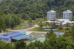
Maliau Basin or also Maliau Basin Conservation Area, is a region in Tongod District of Sabah, Malaysia, which represents a geological catchment surrounding the Maliau River. Located around the centre of Sabah in the Sandakan Division, it was designated as a conservation area by the Sabah Foundation in 1981. Later in 1997 the Sabah State Assembly gazetted the Basin as a Protection Forest Reserve with a total area of 588 square kilometres. The region also features Mount Lotung, Maliau Falls, and Lake Linumunsut. Efforts are underway to nominate the area as a World Heritage Site. In 2011, the Maliau Basin Studies Centre opened, a large field centre to serve as a basis for studies and teaching carried out in Maliau by naturalists, biologists, and groups of field course students.

The San Miguel Province is one of the thirteen provinces in the Cajamarca Region of Peru. It was created by Law No. 15152 on September 29, 1964 by president Fernando Belaunde Terry. It has a mountainous territory which varies in height from 500 to more than 4,000 metres (1,600–13,000 ft) above sea level. As a result, there is a great diversity of climates ranging from hot and dry at lower altitudes to cold and rainy at higher levels. Herding is an important economic activity thanks to the existence of extensive pastures. Its main product is cow's milk which is either sold outside the province or transformed into dairy products such as cheese. There are several gold mines in production in the higher regions of the province. There's also an important handicraft industry mainly devoted to textiles made out of cotton or wool.
Tongod District is one of thirteen districts of the province San Miguel in Peru.

A humid subtropical climate is a zone of climate characterized by hot and humid summers, and cool to mild winters. These climates normally lie on the southeast side of all continents, generally between latitudes 25° and 40° and are located poleward from adjacent tropical climates. It is also known as warm temperate climate in some climate classifications.
Maliau Falls is best known for its seven tiers falls. It is the largest of all the waterfalls known in the Maliau Basin Conservation Area in Tongod District, Sabah, Malaysia. Takob Akob waterfall and Giluk waterfall are located in the same area.

Kinabatangan is a federal constituency in Sandakan Division, Sabah, Malaysia, that has been represented in the Dewan Rakyat since 1971.

The Beluran District is an administrative district in the Malaysian state of Sabah, part of the Sandakan Division which includes the districts of Beluran, Kinabatangan, Sandakan, Telupid and Tongod. The capital of the district is in Beluran Town.

The Kinabatangan District is an administrative district in the Malaysian state of Sabah, part of the Sandakan Division which includes the districts of Beluran, Kinabatangan, Sandakan, Telupid and Tongod. The capital of the district is in Kinabatangan Town.

The Sandakan District is an administrative district in the Malaysian state of Sabah, part of the Sandakan Division which includes the districts of Beluran, Kinabatangan, Sandakan, Telupid and Tongod. The capital of the district is in Sandakan City.

Greta Tintin Eleonora Ernman Thunberg is a Swedish environmental activist who is known for challenging world leaders to take immediate action for climate change mitigation.
Tongod District may refer to:
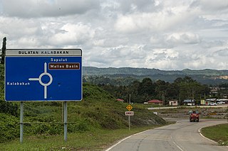
Kalabakan is a district in the Malaysian state of Sabah, located approximately 235 kilometres (146 mi) southeast of the state capital of Kota Kinabalu. It recorded a population of 48,195 people in the 2020 Malaysian census. Its capital is the town of Kalabakan.