Kota Kinabalu, colloquially referred to as KK, is the state capital of Sabah, Malaysia. It is also the capital of the Kota Kinabalu District as well as the West Coast Division of Sabah. The city is located on the northwest coast of Borneo facing the South China Sea. The Tunku Abdul Rahman National Park lies to its west and Mount Kinabalu, which gave the city its name, is located to its east. Kota Kinabalu has a population of 452,058 according to the 2010 census; when the adjacent Penampang and Putatan districts are included, the metro area has a combined population of 628,725. The 2020 Census revealed an increase in the municipal population to 500,421, while the wider area including Penampang and Putatan Districts had a population of 731,406.

Kudat is the capital of the Kudat District in the Kudat Division of Sabah, Malaysia. Its population was estimated to be around 29,025 in 2010. It is located on the Kudat Peninsula, about 190 kilometres (120 mi) north of Kota Kinabalu, the state capital, and is near the northernmost point of Borneo. It is the largest town in the heartland of the Rungus people which is a sub-ethnic group of the majority Kadazan-Dusun race and is therefore a major centre of Rungus culture. It is also notable for being one of the first parts of Sabah to be settled by Chinese Malaysians, particularly from the Hakka dialect group. It is the Northernmost Malaysian city.

Lawas is a small town and the capital of Lawas District, Limbang Division, Sarawak, Malaysia. This district area is 3,811.90 square kilometres, and population was 46,200. It is 1,200 km from the state capital, Kuching and 200 km from the capital city of Sabah, Kota Kinabalu.

The Ranau District is an administrative district in the Malaysian state of Sabah, part of the West Coast Division which includes the districts of Kota Belud, Kota Kinabalu, Papar, Penampang, Putatan, Ranau and Tuaran. The capital of the district is in Ranau Town. The landlocked district bordering the Sandakan Division to the east until it meets the Interior Division border. Ranau sits 108 km (67 mi) east of Kota Kinabalu and 227 km (141 mi) west of Sandakan. As of the 2010 Census, the population of the district was 94,092, an almost entirely Dusun ethnic community.

Papar is the capital of the Papar District in the West Coast Division of Sabah, Malaysia. Its population was estimated to be around 124,420 in 2010, which is divided between Bruneian Malay, Kadazan-Dusun, and Bajau. There is also a sizeable Chinese minority, predominantly of the Hakka subgroup, as well as smaller numbers of other races. The town is located 38 kilometres south of the state capital of Kota Kinabalu, with the Papar railway station in the town becoming one of the main stops of the Sabah State Railway.

Keningau is the capital of the Keningau District in the Interior Division of Sabah, Malaysia. It is the fifth-largest town in Sabah, as well one of the oldest. Keningau is between Tambunan and Tenom. The town had an estimated population of 173,130.

Tenom is the capital of the Tenom District in the Interior Division of Sabah, Malaysia. Its population was estimated to be around 5,148 in 2010. It is located about 176 kilometres south of Kota Kinabalu and 128 kilometres north of Long Pasia, which is the one of the famous attraction in Sabah. In the early days of British colonial rule in Malaysia, the town was called Fort Birch. The town is considered the unofficial capital of the Murut community, whose most important festival, the annual Pesta Kalimaran, is held in the town. It is also the main gateway to other areas within the Murut heartland and the minority of Lundayeh.

Tambunan is the capital of the Tambunan District in the Interior Division of Sabah, Malaysia. Its population was estimated to be around 35,667 in 2010. It is located 80 kilometres east of the state capital, Kota Kinabalu, 48 kilometres south of Ranau and 48 kilometres north of Keningau. At an average altitude of 750 metres, this valley town, which is part of the Crocker Range, experiences a mild tropical climate all year long. The valley is peppered with terraced paddy fields and 70 villages. The dense forests of bamboo around Tambunan town are a legacy of the British colonial period, during which an edict stated that 20 bamboo sprouts had to be planted for every bamboo cut.

Inanam is a suburb and sub-district of Kota Kinabalu in Sabah, Malaysia. It is situated 10 kilometres from the city centre.
Sabah State Railway (SSR) is a railway system and operator in the state of Sabah in Malaysia. It is the only rail transport system operating on the island of Borneo. The railway consists of a single 134-kilometre line from Tanjung Aru, Kota Kinabalu in West Coast Division to the town of Tenom, in the Interior Division. It was formerly known as North Borneo Railway.

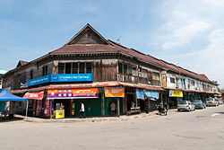
Tamparuli is a small town and a sub-district of Tuaran on the west coast of Sabah, Malaysia. It is populated mainly by native Dusuns, while a sizeable Chinese community runs most of the shops in the town proper. As with many other small towns in Sabah and indeed Malaysia as a whole, the town itself consists of both newer concrete shoplots as well as old wooden ones, which are particularly prone to destruction by fire as evidenced in the destruction of one of the wooden shoplots in recent years. Now, Tamparuli is said to have the potential to grow with the convenience of a new shop site called Tamparuli Point.

Kimanis is a town and also a parliamentary constituency in Papar District, West Coast Division of Sabah, Malaysia. It is located approximately 45 kilometres south of the city of Kota Kinabalu, halfway between Papar and Beaufort.

Universiti Malaysia Sabah is a public university in Malaysia. It was officially established on 24 November 1994 as the ninth public university in the country. The university is located on a 999-acre site at Sepanggar Bay in Kota Kinabalu in the Malaysian state of Sabah. With Mount Kinabalu and the South China Sea as its background, UMS is often considered as among the most beautiful campuses in Southeast Asia.
The Basel Christian Church of Malaysia or BCCM, formerly known as Borneo Basel Self Established Church, is one of the four Lutheran bodies in Malaysia. It currently has 112 congregations nationwide and 63,000 baptised members.

Greater Kota Kinabalu refers to the dense clusters of regional populated areas surrounding the city of Kota Kinabalu in Malaysia. It comprises the districts of Kota Kinabalu, Penampang, Tuaran and Papar. These districts are also part of the West Coast Division. It was forecasted that in 2019, the combined population of these districts was 1.1 million people, in a combined area of 3,277 km2.

Sutera Harbour is a resort located in the city of Kota Kinabalu, Sabah, Malaysia. It comprised two 5-star hotels, a 27-hole Graham Marsh-designed golf course, a 104-berth marina and an exclusive golf and country club with extensive recreational facilities facing the South China Sea with a background of Tunku Abdul Rahman National Park. In 2014, Singapore-based GSH Corporation has acquired the resort.

The Kota Kinabalu District is an administrative district in the Malaysian state of Sabah, part of the West Coast Division which includes the districts of Kota Belud, Kota Kinabalu, Papar, Penampang, Putatan, Ranau and Tuaran. The capital of the district is in Kota Kinabalu City.

The Papar District is an administrative district in the Malaysian state of Sabah, part of the West Coast Division which includes the districts of Kota Belud, Kota Kinabalu, Papar, Penampang, Putatan, Ranau and Tuaran. The capital of the district is in Papar Town.

The Penampang District is an administrative district in the Malaysian state of Sabah, part of the West Coast Division which includes the districts of Kota Belud, Kota Kinabalu, Papar, Penampang, Putatan, Ranau and Tuaran. The capital of the district is in Penampang Town.