Lahad Datu is the capital of the Lahad Datu District in the Dent Peninsula on Tawau Division of Sabah, Malaysia. Its population was estimated to be around 27,887 in 2010. The town is surrounded by stretches of cocoa and palm oil plantations. It is also an important timber exporting port. The town has an airport for domestic flights.

Sandakan formerly known at various times as Elopura, is the capital of the Sandakan District in Sabah, Malaysia. It is the second largest city in Sabah after Kota Kinabalu. It is located on the Sandakan Peninsula and east coast of the state in the administrative centre of Sandakan Division and was the former capital of British North Borneo. In 2010, the city had an estimated population of 157,330 while the surrounding municipal area had a total population of 396,290. The population of the municipal area had increased to 510,600 by 2020.
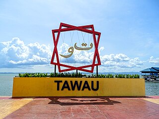
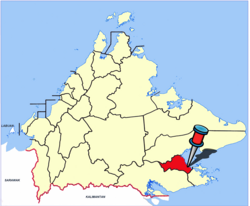
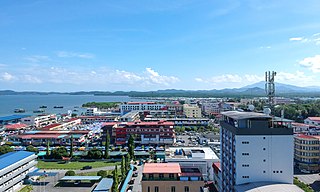
Tawau formerly known as Tawao, is the capital of the Tawau District in Sabah, Malaysia. It is the third-largest city in Sabah, after Kota Kinabalu and Sandakan. It is located on the Semporna Peninsula in the southeast coast of the state in the administrative centre of Tawau Division, which is bordered by the Sulu Sea to the east, the Celebes Sea to the south at Cowie Bay and shares a border with North Kalimantan, Indonesia. The town had an estimated population as of 2010, of 113,809, while the whole municipality area had a population of 397,673.
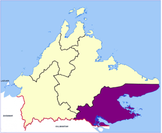
Tawau Division is one of the five administrative sub-divisions of Sabah, Malaysia. It occupies a total of 14,905 square kilometres or 20% of Sabah's territory. The main towns include the capital of Tawau, Lahad Datu, Kunak and Semporna. Tawau division has 26% of Sabah's total population, with the main indigenous groups consisting of the Bajau, Suluk, Ida'an, Tidong, Cocos, Murut, Lun Bawang/Lun Dayeh as well as a minority of mixed ethnic groups. Large numbers of both legal and illegal immigrants from Indonesia such as the Buginese and Torajans, from East Timor the Timorese, from the Philippines the Tausūg and Visayans as well South and West Asian immigrants such as Pakistanis, Indians and Arabs can be found in this area. As with the rest of Sabah, the division also has large numbers of ethnic Chinese.

Semporna is the capital of the Semporna District in the Tawau Division of Sabah, Malaysia. Its population was estimated to be around 35,301 in 2010.

Tambunan is the capital of the Tambunan District in the Interior Division of Sabah, Malaysia. Its population was estimated to be around 35,667 in 2010. It is located 80 kilometres east of the state capital, Kota Kinabalu (to which is connected by the Kota Kinabalu-Tambunan-Keningau Highway, 48 kilometres south of Ranau and 48 kilometres north of Keningau. At an average altitude of 750 metres, this valley town, which is part of the Crocker Range, experiences a mild tropical climate all year long. The valley is peppered with terraced paddy fields and 70 villages. The dense forests of bamboo around Tambunan town are a legacy of the British colonial period, during which an edict stated that 20 bamboo sprouts had to be planted for every bamboo cut.

Tawau Airport is an airport located 15 nautical miles north east of Tawau, Sabah, Malaysia. It is one of two airports in Sabah with immigration counters for international flights, the other being Kota Kinabalu International Airport. Tawau Airport serves the districts of Tawau, Kunak and Semporna and is the nearest airport to the diving islands of Sipadan, Mabul and Kapalai, all of which are located in the latter district.

Cocos Malays are a community that form the predominant group of the Cocos (Keeling) Islands, which is now a part of Australia. Today, most of the Cocos Malay can be found in the eastern coast of Sabah, Malaysia due to ethnic cleansing by the British in the 1950s during the colonial period. Despite that they all have assimilated into the ethnic Malay culture, they are named in reference to the Malay race, originating from different places of the Malay archipelago such as Bali, Bima, Celebes, Madura, Sumbawa, Timor, Sumatra, Pasir-Kutai, Malacca, Penang, Batavia and Cirebon, as well as South Africa and New Guinea.

Lahad Datu Airport is an airport located in the southeastern part of the Malaysian state of Sabah. The airport, which is situated approximately 1 km (0.62 mi) from downtown Lahad Datu, serves the town of Lahad Datu and its neighbouring districts such as Kinabatangan, FELDA Sahabat, and Kunak. The airport can accommodate aircraft as large as the ATR72, and the terminal building can handle up to 100,000 passengers annually. In 2016, the airport handled 140,077 passengers and 3,713 aircraft movements.
Darvel Bay or Lahad Datu Bay is a bight on the east side of Sabah, Malaysia. It is the largest semi-enclosed bay on the east coast of Borneo and faces the Sulawesi Sea. Administratively, it is within Tawau Division, with Lahad Datu District on the north side, Kunak District in the middle and Semporna District to the south of the bay.
Federal Route 13, Asian Highway Route AH150, is a 268 km-long federal highway in Sabah, Malaysia. It is a component of the larger Pan Borneo Highway network. This highway runs primarily along the southeastern coast of Sabah from Sandakan to Tawau. The major towns it passes through include Kinabatangan, Lahad Datu and Kunak.

The Sandakan District is an administrative district in the Malaysian state of Sabah, part of the Sandakan Division which includes the districts of Beluran, Kinabatangan, Sandakan, Telupid and Tongod. The capital of the district is in Sandakan City.

The Lahad Datu District is an administrative district in the Malaysian state of Sabah, part of the Tawau Division which includes the districts of Kunak, Lahad Datu, Semporna and Tawau. The capital of the district is in Lahad Datu Town.

The Semporna District is an administrative district in the Malaysian state of Sabah, part of the Tawau Division which includes the districts of Kunak, Lahad Datu, Semporna and Tawau. The capital of the district is in Semporna Town.

The Tawau District is an administrative district in the Malaysian state of Sabah, part of the Tawau Division which also includes the districts of Kunak, Lahad Datu, Semporna and Tawau. The capital of the district is in Tawau Town.

The Papar District is an administrative district in the Malaysian state of Sabah, part of the West Coast Division which includes the districts of Kota Belud, Kota Kinabalu, Papar, Penampang, Putatan, Ranau and Tuaran. The capital of the district is in Papar Town.

Sabah State Library is a state department under the State Ministry of Education and Innovation Sabah which managing every of the public library branches in Sabah of Malaysia. The headquarters is located in Tasik Road, Off Maktab Gaya Road in Luyang of Kota Kinabalu.

Lahad Datu is a federal constituency in Tawau Division and Sandakan Division, Sabah, Malaysia, that has been represented in the Dewan Rakyat since 2019 was renamed from Silam.
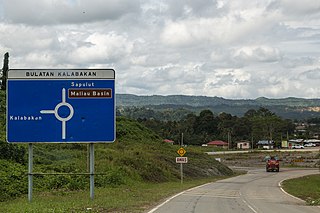
Kalabakan is a district in the Malaysian state of Sabah, located approximately 235 kilometres (146 mi) southeast of the state capital of Kota Kinabalu. It recorded a population of 48,195 people in the 2020 Malaysian census. Its capital is the town of Kalabakan.