
The Sepang District is a district located in the southern part of the state of Selangor in Malaysia. Sepang District covers an area of around 600 square kilometres, and had a population of 190,889 in the 2010 Census.

Hulu Langat District is a district located in the southeastern corner of Selangor, between Kuala Lumpur and Negeri Sembilan. It is bordered by the state of Pahang to the east and north, Gombak district to the north-west, Federal Territory of Kuala Lumpur and Petaling district to the west, Sepang district to the south-west, and state of Negeri Sembilan to the south.

Jasin District is one of the three administrative district in Malacca, Malaysia. It borders Tangkak District of Johor to the east, Tampin District of Negeri Sembilan to the north and Alor Gajah District and Melaka Tengah District to the west. The district capital is Jasin Town.

The Jempol District is the largest district in the Malaysian state of Negeri Sembilan. The district borders Jelebu District to the northwest, Kuala Pilah District to the west, Tampin District to the south, Bera District, Pahang to the northeast and Segamat District, Johor to the east. Bandar Seri Jempol and Bahau are the principal towns in Jempol.

Alor Gajah District is one of the three administrative districts in Malacca, Malaysia. It borders Tampin District, Rembau District and Port Dickson District in Negeri Sembilan to the north and borders Jasin District and Melaka Tengah District in the east and south respectively.

The Jerantut District is a district in north-eastern Pahang, Malaysia. Jerantut is home to the National Park.

The Rompin District is a district located in the southeastern corner of Pahang, Malaysia. Rompin is currently under the Rompin District Council.

The Bera District is a district in southwestern Pahang, Malaysia, bordering Negeri Sembilan and Johor.
Sik District is a district in Kedah, Malaysia. It is largest district in Kedah.
The Yan District is a district in Kedah, Malaysia. It is bordered by Kota Setar District to the north, Pendang District to the northeast and Kuala Muda District to the south. Yan District is along the coast of the Straits of Malacca. It is the smallest municipality in Kedah.

The Central Seberang Perai District is a district in the state of Penang, Malaysia. It covers an area of 238 square kilometres, and had a population of 371,975 at the 2010 Census. The district is bordered by Perai River which separates North Seberang Perai in the north, Junjong River which separates South Seberang Perai in the south, Kedah state border in the east and South Channel which separates Penang Island. Juru River also flows through the district. The capital of this district is Bukit Mertajam. Other localities that are situated in Central Seberang Perai include Permatang Pauh, Penanti, Bukit Tengah, Bukit Minyak, Juru, Alma, Machang Bubok and Permatang Tinggi. The entertainment, eatery and automobile venue of Autocity is also located in this district. Heavy industrial areas cover most parts of Central Seberang Perai.

The South Seberang Perai District is a district in Penang, Malaysia. It covers an area of 242 square kilometres, and had a population of 184,007 at the 2020 Census. The district is bordered by Junjong River that separates Central Seberang Perai in the north, Kedah state border in the east, Perak state border in the south and the South Channel that separates Penang Island. Rivers that flow through South Seberang Perai are Junjong River, Jawi River and Kerian River. The capital of this district is Sungai Jawi and the largest town is Nibong Tebal. Other towns such as Batu Kawan, Bukit Tambun, Simpang Ampat, Sungai Bakap and Valdor are also located in this district. South Seberang Perai is thriving with the fishing industry and agriculture. Oil palm plantations covers most parts of the area.
The Lipis District is a district located in north-west of Pahang, Malaysia. The district covers an area of 5,198 km2. Lipis district is bordered by Cameron Highlands and Perak on the west, Jerantut on the east, Kelantan and Raub on the north and south, respectively. Lipis has 10 mukim or subdistricts, the largest being Ulu Jelai. The district capital is Kuala Lipis. During the British colonization, Kuala Lipis was made the state's capital city. Kuala Lipis was the administrative capital of Pahang for 57 years from 1898 until 27 August 1955, when Kuantan was picked as the new capital. Lipis had many types of minerals such as tin and gold, and products from the surrounding forests.

Pekan is a federal constituency in Pekan District and Kuantan District, Pahang, Malaysia, that has been represented in the Dewan Rakyat since 1959.

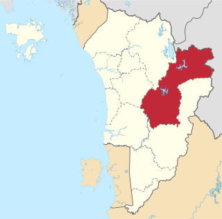
The Kuantan District is a district in Pahang, Malaysia. Located in the north-east of Pahang, the district bordered Kemaman District of Terengganu on the north, South China Sea on the east, Jerantut District and Maran District on the west and Pekan District on the south.
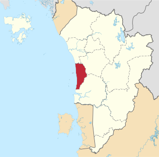
Temerloh District is a district in Pahang, Malaysia. The district consists of two areas, the 1,442-square-kilometre (557 sq mi) Municipal Council Area (64.08%) and the 808-square-kilometre (312 sq mi) outer Municipal Council Area (35.92%). Temerloh district is bordered by Maran District on the east, Bentong District on the west, Jerantut District on the north, and Bera District on the south.
The Kuala Terengganu District is a district in the state of Terengganu, Malaysia. It covers an area of 210.21 square kilometres, and had a population of 343,284 at the 2010 Census. The district is bordered by Terengganu River which separates Kuala Nerus District in the north and west, Marang District in the south and South China Sea in the east. The capital of this district is Kuala Terengganu.

The Maran District is a district in Pahang, Malaysia. Bera district is founded at 1981. Located in the centre of Pahang, the district is surrounded by Kuantan District, Pekan District, Rompin District, Bera District, Temerloh District and Jerantut District clockwisely.

Raub District is a district in Pahang, Malaysia. Located in the west of Pahang, the district bordered Lipis District, Jerantut District, Temerloh District, Bentong District and Hulu Selangor District of Selangor clockwisely. Raub district consists of 7 mukim (sub-districts), namely Batu Talam, Sega, Semantan Ulu, Dong, Ulu Dong, Gali and Tras. With an area of 2,271 km², Raub district is situated in west of Pahang and between two ranges namely Titiwangsa and Benom ranges. Raub district also is home to the hill station of Fraser's Hill. The administrative seat of this district is the town of Raub.
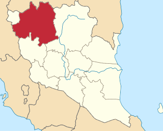
The Kuala Kangsar District is a district in Perak, Malaysia. Kuala Kangsar shares its borders with Larut, Matang and Selama at the west, Hulu Perak at the north, Gua Musang of Kelantan at the east, Kinta at the south, Perak Tengah and Manjung at the southwest. The seat of this district is the town of Kuala Kangsar.


