Pasir Mas District

Last updated
Pasir Mas District
Pase Mah
Jajahan Pasir Mas
Other transcription(s)
   Jawi ڤاسير مس
   Chinese 巴西马县
   Tamil பாசிர் மாஸ்
Flag of Pasir Mas, Kelantan.svg
Pasir Mas highlighted in Kelantan, Malaysia.svg
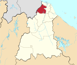
Location of Pasir Mas District in Kelantan
Pasir Mas District
Malaysia location map with districts.svg
Red pog.svg
Pasir Mas District
Location of Pasir Mas District in Malaysia
Coordinates: 6°2′N102°8′E / 6.033°N 102.133°E / 6.033; 102.133
Country Flag of Malaysia.svg  Malaysia
State Flag of Kelantan.svg  Kelantan
Seat Pasir Mas
Local area government(s) Pasir Mas District Council
Government
  District officerHazmi Bin Abdul Hamid [1]
  Administrative officePasir Mas District and Land Office
Area
[2]
  Total570 km2 (220 sq mi)
Population
 (2022) [3]
  Total233,400
  Density410/km2 (1,100/sq mi)
Time zone UTC+8 (MST)
  Summer (DST) UTC+8 (Not observed)
Postcode
17xxx
Calling code +6-09
Vehicle registration plates D

Pasir Mas District is a district (jajahan) in Kelantan, Malaysia. The district covers an area of 614.15 square kilometers and is bordered by the districts of Tumpat District to the north, Tanah Merah District to the south, Kota Bharu District to the east, and the Thai district of Su-ngai Kolok (Malay : Sungai Golok) to the west. [2]

Contents

Due to its geographical location, it acts as the main gateway of the East Coast of Malaysia to Thailand and is also traversed by major road transport routes from the West Coast to the state capital of Kota Bharu.

The district of Pasir Mas was originally part of the district of Kota Bharu. In 1918, the town of Pasir Mas and its surrounding areas were separated from Kota Bharu and granted its own local government. The seat of this district is the town of Pasir Mas.

Transportation

Rail

A railway station operated by Keretapi Tanah Melayu (KTM) is located here. The station is part of KTM Intercity's Rantau Panjang Line and interchanges with the East Coast Line which ends at the Tumpat railway station.

The nightly Ekspres Timuran from Johor Bahru usually reaches here at around 9:00 am. Ekspres Wau departs at 6:30 pm for the 13-hour journey to KL Sentral, Kuala Lumpur. The Rantau Panjang Line continues towards north at Rantau Panjang railway station at the border town of Rantau Panjang and links to the Southern Line of the State Railway of Thailand.

A new railway station which replaced the original one at the same location was completed in July 2008. The reasonable fare attracts small-traders, who would board here with various goods - usually foodstuff from Rantau Panjang - to transport to the interiors. The trains' scheduled arrivals and departures often create traffic jams in the town several times daily. A carriageway connecting Lemal and Kubang Panjang over the railway track has been built to overcome this. Trains no longer stop at the hamlet station of Tok Uban along the way to Tanah Merah.

Bus

From Pasir Mas town, it is possible to go to any state capital in Peninsular Malaysia without having to change buses. However, buses departing from these state capitals with Kota Bharu as the final destination might not pass through Pasir Mas. But those with Rantau Panjang as the final destination, will.

The most popular inter-state bus company is Transnasional, which is majority-owned by a federal government agency. Syarikat Kenderaan Melayu Kelantan (SKMK) has a monopoly of inter-district and intra-district bus routes. There are direct buses to the main towns of Kota Bharu, Rantau Panjang and Tanah Merah and vice versa; which depart every 30 minutes from 7:00 am to 6:30 pm. The bus station is at the centre of the town; about 100 metres from the train station.

Population

Historical population
YearPop.±%
1991 150,035    
2000 162,312+8.2%
2010 180,878+11.4%
2020 230,424+27.4%
Source: [4]
Map of Pasir Mas District Map of Pasir Mas District, Kelantan.svg
Map of Pasir Mas District

Pasir Mas as of 2010 Census, it has a population of 189,292 people. [3]

Ranking Population of Jajahan Pasir Mas. [5]

RankDaerahPopulation 2000
1 Rantau Panjang 23,714
2Kubang Gadong22,931
3Pasir Mas21,681
4Kangkong16,488
5Gual Periok15,326
6Bunut Susu15,008
7Kubang Sepat14,484
8Chetok12,576
9Lemal10,753
10Alor Pasir9,351

Federal Parliament and State Assembly Seats


List of LMS district representatives in the Federal Parliament (Dewan Rakyat)

ParliamentSeat NameMember of ParliamentParty
P22 Pasir Mas Ahmad Fadhli Mohd Shaari Perikatan Nasional (PAS)
P23 Rantau Panjang Siti Zailah Mohd Yusoff Perikatan Nasional (PAS)


List of LMS district representatives in the State Legislative Assembly of Kelantan

ParliamentStateSeat NameState AssemblymanParty
P22N11 Tendong Rozi Mohamad Perikatan Nasional (PAS)
P22N12 Pengkalan Pasir Hanifa Ahmad Perikatan Nasional (PAS)
P22N13 Meranti Mohd. Nassuruddin Daud Perikatan Nasional (PAS)
P23N14 Chetok Zuraidin Abdullah Perikatan Nasional (PAS)
P23N15 Gual Periok Mohamad Awang Perikatan Nasional (PAS)
P23N16 Apam Putra Abdul Rasul Mohamed Perikatan Nasional (PAS)

Education

Several types of schools can be found in Pasir Mas. [6] Among the schools in Pasir Mas are

Related Research Articles

<span class="mw-page-title-main">Kota Bharu</span> Place in Kelantan, Malaysia

Kota Bharu, colloquially referred to as KB, is a town in Malaysia that serves as the state capital and royal seat of Kelantan. It is situated in the northeastern part of Peninsular Malaysia and lies near the mouth of the Kelantan River.

<span class="mw-page-title-main">Tumpat District</span> District of Malaysia in Kelantan


Tumpat is a town, a district (jajahan) and parliamentary constituency in northern Kelantan, Malaysia, at the mouth of Kelantan River.

<span class="mw-page-title-main">Jeli District</span> District of Malaysia in Kelantan

The Jeli District is a district and a parliamentary constituency in western Kelantan, Malaysia. As of 2010, the district's population is estimated to be 42,150. Jeli is administered by the Jeli District Council. Jeli is bordered by the state of Perak to the west, the Thai district of Waeng to the north, Tanah Merah district to the north east and Kuala Krai district to the south east.

Federal Route 3 is a main federal road running along the east coast of Peninsula Malaysia. The 739 kilometres (459 mi) federal highway connects Rantau Panjang in Kelantan until Johor Bahru in Johor. The entire FT3 highway is gazetted as a part of the Asian Highway Network route 18.

<span class="mw-page-title-main">Ismail Petra of Kelantan</span> Sultan of Kelantan

Sultan Ismail Petra ibni Almarhum Sultan Yahya Petra was the 28th Sultan of Kelantan and the 11th Sultan of Modern Kelantan who reigned from 30 March 1979 to 13 September 2010. He succeeded on the death of his father, Sultan Yahya Petra. Sultan Ismail Petra died at the Royal Ward Raja Perempuan Zainab II Hospital in Kota Bharu on 28 September 2019, aged 69, after 10 years of suffering from a massive stroke and was buried at the Kelantan Royal Mausoleum. He was succeeded by his eldest son, Sultan Muhammad V who ascended the throne on 13 September 2010.

<span class="mw-page-title-main">Gua Musang District</span> District of Malaysia in Kelantan

Gua Musang is a town, district and parliamentary constituency in southern Kelantan, Malaysia. It is the largest district in Kelantan. Gua Musang is administered by the Gua Musang District Council. Gua Musang district is bordered by the state of Pahang to the south, Terengganu to the east, Perak to the west and the Kelantanese districts of Kuala Krai and Jeli to the north. It is a small railway town about 140 km south of state capital Kota Bharu. Gua Musang is represented by Mohd Azizi Abu Naim in the Dewan Rakyat. The town lies on the KTM East Coast Line, from Tumpat, near the border with Thailand, to Gemas, Negeri Sembilan.

<span class="mw-page-title-main">Machang District</span> District of Malaysia in Kelantan

Machang is one of the ten districts in the state of Kelantan, Malaysia. It is situated at the centre of the state, bordering with Kelantanese territories of Kota Bharu to the north, Pasir Puteh to the east,Terengganu State to the southeast, Tanah Merah to the west and Kuala Krai to the south. Its major town and administrative centre is Machang town.

<span class="mw-page-title-main">Besut District</span> District of Malaysia in Terengganu

Besut is a district in Terengganu, Malaysia. It is bordered by the state of Kelantan to the north and west and the South China Sea to the east. It is the northern gateway to Terengganu. Kampung Raja is the district capital, though Jerteh is more developed. Another major town is the fishing port of Kuala Besut. There are other small towns and villages such as Jabi, Apal, Pasir Akar and Tembila.

<span class="mw-page-title-main">Pasir Puteh District</span> District of Malaysia in Kelantan

Pasir Puteh District is a district (jajahan) in Kelantan, Malaysia. The town of Pasir Putih is situated on the bank of Semerak River, about 30 kilometers to the south of Kota Bharu. Pasir Puteh district borders Besut District, Terengganu to its south-east.

<span class="mw-page-title-main">Bachok District</span> District of Malaysia in Kelantan

Bachok District is an administrative division of Kelantan, Malaysia. It is located approximately 25 km east of Kota Bharu.

<span class="mw-page-title-main">Kuala Krai District</span> District of Malaysia in Kelantan

Kuala Krai District is a district (jajahan) in Kelantan, Malaysia. Historically, it was known as Kuala Lebir.

<span class="mw-page-title-main">Tanah Merah District</span> District of Malaysia in Kelantan

Tanah Merah District is a district (jajahan) in the state of Kelantan in northeast Malaysia. The urban area of Tanah Merah is situated along the Kelantan River. It is bordered by Pasir Mas District in the north, Machang District to the East, Kuala Krai District to the South East, Jeli District to the South West and Thailand in the West.

<span class="mw-page-title-main">Wakaf Bharu</span> Suburb of Kota Bharu in Tumpat, Kelantan, Malaysia

Wakaf Bharu is a satellite town in Tumpat District, Kelantan, Malaysia. It is located approximately 9 km (5.6 mi) from Kota Bharu, the state capital city.

<span class="mw-page-title-main">Rantau Panjang railway station</span>

The Rantau Panjang railway station was a Malaysian railway station located near Jalan Besar and named after the town of Rantau Panjang, Kelantan. Opened in 1921, it is located on the Rantau Panjang branch line, branching off from the main KTM East Coast Line at Pasir Mas. Rantau Panjang is one of the two rail border crossings on the border with Thailand, though currently there is no cross-border train crossing the Malaysia–Thailand border at Rantau Panjang. The Thai entrance to the Harmony rail bridge is currently sealed off by the Royal Thai Army.

<span class="mw-page-title-main">Kota Bharu District</span> District of Malaysia in Kelantan

The Kota Bharu District is a district in northern Kelantan, Malaysia. As of 2020, the district's population is estimated to be 608,600. It contains the state capital, Kota Bharu, as well as Pengkalan Chepa and Ketereh.

References

  1. "Perutusan Ketua Jajahan". www.ptjpm.kelantan.gov.my. Retrieved 2022-09-09.
  2. 1 2 "Laman Web Rasmi - Pejabat Tanah Dan Jajahan Pasir Mas - Sejarah Jabatan". www.ptjpm.kelantan.gov.my. Archived from the original on 2019-03-07. Retrieved 2017-11-27.
  3. 1 2 "Population Distribution and Basic Demographic Characteristics, 2010" (PDF). Department of Statistics, Malaysia. Archived from the original (PDF) on 22 May 2014. Retrieved 19 April 2012.
  4. "Key Findings of Population and Housing Census of Malaysia 2020" (pdf) (in Malay and English). Department of Statistics, Malaysia. ISBN   978-967-2000-85-3.
  5. "Laman Web Rasmi - Pejabat Tanah Dan Jajahan Pasir Mas - Daerah Di Pasir Mas". www.ptjpm.kelantan.gov.my.
  6. "Secondary Schools in Kelantan, Malaysia". 2007. Retrieved 2007-12-10.