Tangkak District

Last updated

Tangkak District
Daerah Tangkak
Other transcription(s)
   Jawi تڠكق
   Chinese 東甲縣
   Tamil தங்காக்
Flag of Tangkak, Johor.svg
Motto(s): 
Berusaha untuk Makmur(in Malay)
"Striving to Prosper"
Tangkak highlighted in Johor, Malaysia.svg
Location of Tangkak District in Johor
Tangkak District
Malaysia location map with districts.svg
Red pog.svg
Tangkak District
Location of Tangkak District in Malaysia
Coordinates: 2°16′N102°33′E / 2.267°N 102.550°E / 2.267; 102.550
Country Flag of Malaysia.svg  Malaysia
State Flag of Johor.svg  Johor
Seat Tangkak
Local area government(s) Tangkak District Council
Government
  District officerHaji Shafiei bin Ahamad
Area
[1]
  Total970.24 km2 (374.61 sq mi)
Population
 (2010) [2]
  Total129,280
  Density130/km2 (350/sq mi)
Time zone UTC+8 (MST)
  Summer (DST) UTC+8 (Not observed)
Postcode
849xx
Calling code +6-06
Vehicle registration plates J
Tangkak District Council Tangkak District Council.JPG
Tangkak District Council

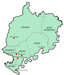
The Tangkak District is a district in western Johor, Malaysia, bordering Muar District to the south, Segamat District to the northeast, and Jasin District, Malacca to the west. The district also shares a 11 kilometre border with Tampin District, Negeri Sembilan to the northwest. The district capital and largest settlement is the town of Tangkak. Other towns include Sagil, Sungai Mati and Tanjung Agas.

Contents

Geography

Mount Ledang, the prominent landmark of the district. Seen from downtown Tangkak. Tangkak 1.jpg
Mount Ledang, the prominent landmark of the district. Seen from downtown Tangkak.

Along with Muar, Batu Pahat and Segamat, Tangkak District is one of the districts that constitute the northern part of Johor. The Muar River delineates the boundary with Muar District to its south, from Durian Chondong in the east towards Tanjung Agas on the Malacca Strait coast. To its northeast, the district's famed landmark, Mount Ledang, is situated close to the tripoint between the neighbouring states of Malacca and Negeri Sembilan, where it is the highest point statewide at 1,276 metres (4,186 ft).

History

The district was previously an autonomous sub-district (daerah kecil) covering the north-western part of the Muar District, separated from Muar Town proper by the Muar River. [3] A ceremony headed by the sultan on 9 June 2008 saw the official proclamation of that part becoming Johor's 10th district, then named Ledang District after the eponymous mountain located within its borders. [4] The district was then renamed Tangkak District at the end of 2015 by a decree of Sultan Ibrahim Ismail to preserve the historical value of traditional name of places in the state. [5] [6] [7]

Administrative divisions

Map of Tangkak District, Johor.svg

Tangkak District is divided into:

Mukims

Towns (Bandar)

Hamlets (Pekan)

Townships

Demographics

Historical population
YearPop.±%
2010 131,890    
2020 163,449+23.9%
Figures before 2008 is included under Muar District.
Source: [8]

Federal Parliament and State Assembly Seats


List of Tangkak district representatives in the Federal Parliament (Dewan Rakyat)

ParliamentSeat NameMember of ParliamentParty
P143 Pagoh Muhyiddin Yassin Perikatan Nasional (PPBM)
P144 Ledang Syed Ibrahim Syed Noh Pakatan Harapan (PKR)


List of Tangkak district representatives in the State Legislative Assembly (Dewan Negeri)

ParliamentStateSeat NameState AssemblymanParty
P143N7 Bukit Kepong Sahruddin Jamal Perikatan Nasional (PPBM)
P144N9 Gambir Sahrihan JaniBarisan Nasional (UMNO)
P144N10 Tangkak Ee Chin LiPakatan Harapan (DAP)
P144N11 Serom Khairin Nisa IsmailBarisan Nasional (UMNO)

Economy

The main economy activities in the district are lifestyle tourism, adventure sports, light manufacturing and agriculture. [9] Main industrial areas in the district are Desa Serom, Desa Sungai Mati, Gerisek, Sagil and Tangkak Industrial Areas. [10]

Tourist attractions

Mount Ledang National Park

A waterfall in Gunung Ledang National Park Gunung Ledang waterfall.jpg
A waterfall in Gunung Ledang National Park

One of the main tourist attractions of Tangkak is the Gunung Ledang National Park. The park is situated 170 km from Johor Bahru and has an area of 107 km2. The park has two entry points, one in Sagil and the other in Asahan, from the Malaccan side. Mount Ledang's peak, which is 1,276 m above sea level, is the highest point in Johor and has been frequently climbed by many people all year round. Sagil Falls, which is also in the park is a famous picnic site. Mount Ledang is also widely recognised as a friendly training venue for amateur (or beginners) mountain hikers/climbers.

See also

Related Research Articles

<span class="mw-page-title-main">Batu Pahat District</span> District of Malaysia in Johor

The Batu Pahat District is a district in the state of Johor, Malaysia. It lies southeast of Muar, southwest of Kluang, northwest of Pontian, south of Segamat and Tangkak District. The capital of the district is Bandar Penggaram.

<span class="mw-page-title-main">Johor Bahru District</span> District of Malaysia in Johor

The Johor Bahru District is a district located in the southern part of Johor, Malaysia. The heavily suburban/suburbanizing district covers an area of 1,063.97 km2 (410.80 sq mi) and has a population of 1.71 million. The district capital is Johor Bahru City and the administrative capital is Iskandar Puteri City. The district borders Pontian District on the west, Kota Tinggi District on the east, Kulai District on the north and Straits of Johor to the south. The urban centres are divided into the cities of Johor Bahru, Iskandar Puteri and Pasir Gudang.

<span class="mw-page-title-main">Segamat District</span> District in Johor, Malaysia

The Segamat District or simply Segamat is a district in the Malaysian state of Johor. Segamat is also the name of the district's primary town. Segamat district is one of the three landlocked districts in Johor, the other being Kluang and Kulai.

<span class="mw-page-title-main">Muar River</span> River in Johor and Negeri Sembilan, Malaysia

The Muar River is a river which flows through the states of Negeri Sembilan and Johor in Malaysia. Its drainage basin encompasses the states aforementioned, as well as Pahang and Malacca.

<span class="mw-page-title-main">Malaysia Federal Route 23</span> Road in Malaysia

Federal Route 23, or Jalan Muar–Tangkak–Segamat, is a federal road in Johor, Malaysia, connecting Segamat in the north and Parit Bunga in the south. It is also a main route to North–South Expressway Southern Route via Tangkak Interchange.

<span class="mw-page-title-main">Sultan Ismail Bridge</span> Bridge in Federal Route Muar–Melaka Highway, Muar

The Sultan Ismail Bridge is a bridge in Muar town across the Muar River in Johor, Malaysia. It was the first bridge built across a river that connects Bandar Maharani, Muar to Tanjung Agas which is now named as part of Tangkak district. The bridge replaced old ferry services in the 1960s. The bridge was originally a toll bridge making the second toll bridge in Malaysia after Sultan Yahya Petra Bridge in Kelantan.

<span class="mw-page-title-main">Tangkak</span> Town and district capital in Johor, Malaysia

Tangkak is a town and the capital of Tangkak District in Johor, Malaysia. The town is nicknamed "Fabric Town" or "Syurga Kain" in honour of its many textile shops. It is also well known as being a major entry point to Mount Ledang, the highest mountain in Johor.

<span class="mw-page-title-main">Sagil</span> Town in Malaysia in Johor

Sagil is a small settlement in Tangkak District, Johor, Malaysia. Sagil is near the border of Johor with Malacca. Air Panas Waterfall is located here, and access to the peak of Gunung Ledang. Gunung Ledang is around 5 minute driving distance from Sagil town.

<span class="mw-page-title-main">Bukit Kangkar</span> Place in Johor, Malaysia

Bukit Kangkar is a small town in Mukim Serom, Tangkak District, Johor, Malaysia. The town is approximately 16 km from Muar and 12 km from Tangkak. The town is centered on villages and modern housing areas. The 2 main villages are Kampung Parit Pelampong and Kampung Gelugur.

Bukit, the Indonesian or Malay word for hill, may refer to:

<span class="mw-page-title-main">Kulai District</span> District of Malaysia in Johor

The Kulai District is a district in the state of Johor, Malaysia. Its district capital is Kulai Town. It covers Kulai Town, Ayer Bemban, Bandar Putra Kulai, Bukit Batu, Indahpura, Bandar Baru Kangkar Pulai, Kelapa Sawit, Saleng, Sedenak, Seelong, Senai, and Sengkang. Kulai is also within Iskandar Malaysia economic zone.

<span class="mw-page-title-main">Muar District</span> District of Malaysia in Johor

The Muar District is a district in Johor, Malaysia. Muar is located at the mouth of the Muar River, on the coast of the Straits of Malacca. The Muar District covers 1,354 km2 (523 sq mi), with a population of 233,779 (2010).

<span class="mw-page-title-main">Muar (town)</span> Royal capital and district capital in Johor, Malaysia

Muar or Bandar Maharani, is a historical town and the capital of Muar District, Johor, Malaysia. It is one of the most popular tourist attractions in Malaysia to be visited and explored for its food, coffee and historical prewar buildings. It was recently declared as the royal town of Johor by Sultan Ibrahim Sultan Iskandar and is the fourth largest urban area in Johor. It is the main and biggest town of the bigger entity region or area of the same name, Muar which is sub-divided into the Muar district and the new Tangkak district, which was upgraded into a full-fledged district from the Tangkak sub-district earlier. Muar district as the only district covering the whole area formerly borders Malacca in the northern part. Upon the upgrading of Tangkak district, the Muar district now covers only the area south of Sungai Muar, whilst the northern area beyond the river is in within Tangkak district. However, both divided administrative districts are still collectively and fondly called and referred to as the region or area of Muar as a whole by their residents and outsiders. Currently, the new township of Muar is located in the Bakri area.

<span class="mw-page-title-main">Mount Ledang</span> Mountain in Malaysia

Mount Ledang is a mountain located in Tangkak District, Johor, Malaysia. The summit is located next to the tripoint of Tangkak, Jasin and Tampin districts, located in the states of Johor, Malacca and Negeri Sembilan, respectively. Standing at 1,276 m (4,186 ft), it is the 64th highest mountain in Malaysia and the highest peak in Johor.

<span class="mw-page-title-main">Parit Bunga</span> Town in Johor, Malaysia

Parit Bunga is a small town in Mukim Kesang, Tangkak District, Johor, Malaysia. It is located on the Muar River and on the intersection between the roads to Malacca and Tangkak.

<span class="mw-page-title-main">Kota Tinggi District</span> District in Johor, Malaysia

Kota Tinggi District is a district in the Malaysian state of Johor. It is the largest district in the state with an area of 3,488.7 square kilometres (1,347.0 sq mi). The population was 187,824 in 2010. The principal town is Kota Tinggi.

<span class="mw-page-title-main">Negeri FM</span> Radio station in Seremban

Negeri FM is a Malay language-radio station broadcasting from Seremban, Negeri Sembilan, Malaysia which is operated by the Radio Televisyen Malaysia (RTM). Negeri FM has been in operation since 1990. It provides the latest news, plays Western music, other entertainment, religious programmes etc. It covers the areas of Negeri Sembilan, Klang Valley, Malacca, northern Johor and parts of Pahang in Malaysia. Negeri FM is transmitted in both standard and Negeri Sembilan Malay. Negeri FM provides hourly news broadcasts. Negeri FM broadcasts in Negeri Sembilan on 92.6 MHz.

References

  1. "Profil Daerah". ptj.johor.gov.my.
  2. "Population Distribution and Basic Demographic Characteristics, 2010" (PDF). Department of Statistics, Malaysia. Archived from the original (PDF) on 22 May 2014. Retrieved 19 April 2012.
  3. "Ledang becomes 10th district". Archived from the original on 5 October 2012.
  4. "Ledang set to become Johor's newest district". The Star Online. Star Media Group Berhad. 1 June 2008. Retrieved 24 July 2016.
  5. "Johor's administrative capital Nusajaya to be renamed Iskandar Puteri". Straits Times . Singapore Press Holdings Ltd. 7 December 2015. Retrieved 24 July 2016.
  6. Zazali Musa (7 December 2015). "Nusajaya to be renamed Iskandar Puteri". The Star Online . Retrieved 16 March 2019.
  7. Ben Tan (7 December 2015). "Name changes for Johor districts". The Rakyat Post . Retrieved 16 March 2019.
  8. "Key Findings of Population and Housing Census of Malaysia 2020" (pdf) (in Malay and English). Department of Statistics, Malaysia. ISBN   978-967-2000-85-3.
  9. "Muafakat ke Arah #Johor Berkemajuan" (PDF). Muafakat Johor (in Malay). Retrieved 17 March 2018.
  10. Handbook johor.gov.my