Rengit

Last updated
Rengit
Town and sub-district
Other transcription(s)
   Jawi رڠيت
   Chinese 龙引
Rengit.JPG
Flag of Johor.svg
Batu Pahat Emblem.svg
Malaysia location map.svg
Red pog.svg
Rengit
Location in Malaysia
Coordinates: 1°40′50″N103°08′50″E / 1.68056°N 103.14722°E / 1.68056; 103.14722
Country Malaysia
State Johor
City Batu Pahat
Government
   Local Authority Majlis Perbandaran Batu Pahat
Area
[1]
  Total645.12 km2 (249.08 sq mi)
Time zone UTC+8 (MST)
Postcode
83100
Dialling code +607
Police Batu Pahat
Fire Batu Pahat

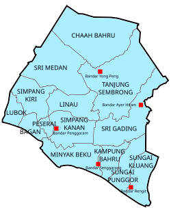
Rengit is a town and an autonomous sub-district in Mukim Sungai Kluang, Batu Pahat District, Johor, Malaysia. [2] Rengit has more than 30 villages and 25 schools.

Contents

Geography

Bandar Rengit in Batu Pahat District Map of Batu Pahat District, Johor.svg
Bandar Rengit in Batu Pahat District

The town spans over an area of 6.5 km2. [3] The area of Rengit sub-district is approximately 100.8 square miles or 64,512 hectares and divided into 3 mukims namely the Kampung Bahru, Sungai Punggur and Sungai Kluang District where each mukim is governed by a Chief. [4]

Demographic

The Malays are the largest ethnic group in Rengit but there is also a significant Javanese, Chinese and Indian minority as well. The people in Rengit have their own unique dialect of Johor Malay.

Languages

Malay is the most widely spoken language in Rengit and is the native language of the Malays as well as the main lingua franca for inter-ethnic communications. The Chinese usually speak Hokkien and Mandarin amongst themselves while Indians spoke Tamil as their native language.

Education

Religion

The majority population practice Islam, followed by Chinese folk religion (including Taoism), Buddhism and Christianity.

Place of worship

Notable residents

Neighbouring towns

Related Research Articles

<span class="mw-page-title-main">Kluang District</span> District of Malaysia in Johor

The Kluang District is a district in Johor, Malaysia. Its district capital is Kluang Town. Kluang district is one of the three landlocked districts in Johor, the other being Segamat and Kulai.

<span class="mw-page-title-main">Kedah</span> State of Malaysia

Kedah, also known by its honorific Darul Aman and historically as Queda, is a state of Malaysia, located in the northwestern part of Peninsular Malaysia. The state covers a total area of over 9,000 km2, and it consists of the mainland and the Langkawi islands. The mainland has a relatively flat terrain, which is used to grow rice, while Langkawi is an archipelago, most of which are uninhabited islands.

<span class="mw-page-title-main">Batu Pahat District</span> District of Malaysia in Johor

The Batu Pahat District is a district in the state of Johor, Malaysia. It lies southeast of Muar, southwest of Kluang, northwest of Pontian, south of Segamat and Tangkak District. The capital of the district is Bandar Penggaram.

<span class="mw-page-title-main">Segamat District</span> District in Johor, Malaysia

The Segamat District or simply Segamat is a district in the Malaysian state of Johor. Segamat is also the name of the district's primary town. Segamat district is one of the three landlocked districts in Johor, the other being Kluang and Kulai.

<span class="mw-page-title-main">Batu Gajah</span> Town and district capital in Perak, Malaysia

Batu Gajah is the seat of Kinta District, Perak, Malaysia. It is administered by the Batu Gajah District Council, formerly known as Kinta West District Council.

<span class="mw-page-title-main">Pontian District</span> District of Malaysia in Johor

Pontian District is a district located in southwest part of the Malaysian state of Johor. It borders Batu Pahat and Kluang Districts to the north and Kulai and Johor Bahru Districts to the east.

<span class="mw-page-title-main">Yong Peng</span> Township in Johor, Malaysia

Yong Peng is a town in Mukim Tanjung Semberong, Batu Pahat District, Johor, Malaysia. It has an area of 1911.6 hectares with an estimated population of 29,046.

<span class="mw-page-title-main">Parit Raja</span> Township in Johor, Malaysia

Parit Raja is a town in Batu Pahat District, Johor, Malaysia. The main population of this town and its surrounding areas has been resided by Malay with Javanese descent, besides the Chinese population.

<span class="mw-page-title-main">Sri Gading</span> Suburb of Batu Pahat in Johor, Malaysia

Sri Gading or Seri Gading is a mukim and parliamentary constituency in Batu Pahat District, Johor, Malaysia, located along Jalan Batu Pahat-Kluang. It lies south-east of Batu Pahat town, north-west of Ayer Hitam and west of Yong Peng. It is also a name of one of 14 parishes in Johor.

<span class="mw-page-title-main">Kulai District</span> District of Malaysia in Johor

The Kulai District is a district in the state of Johor, Malaysia. Its district capital is Kulai Town. It covers Kulai Town, Ayer Bemban, Bandar Putra Kulai, Bukit Batu, Indahpura, Bandar Baru Kangkar Pulai, Kelapa Sawit, Saleng, Sedenak, Seelong, Senai, and Sengkang. Kulai is also within Iskandar Malaysia economic zone.

<span class="mw-page-title-main">Sardon Jubir</span> Malaysian politician (1917–1985)

Tun Sardon bin Jubir was a Malaysian politician. He served as Minister of Health, Minister of Works and Communications and was the Yang di-Pertua Negeri (Governor) of Penang from 1975 to 1981.

<span class="mw-page-title-main">Muar District</span> District of Malaysia in Johor

The Muar District is a district in Johor, Malaysia. Muar is located at the mouth of the Muar River, on the coast of the Straits of Malacca. The Muar District covers 1,354 km2 (523 sq mi), with a population of 233,779 (2010).

Batu Pahat (BP) is a town and capital of Batu Pahat District, Johor, Malaysia. It lies south-east of Muar, south-west of Kluang, north-west of Pontian and south of Segamat. The town area is located inside Simpang Kanan parishes.

<span class="mw-page-title-main">Kota Tinggi District</span> District in Johor, Malaysia

Kota Tinggi District is a district in the Malaysian state of Johor. It is the largest district in the state with an area of 3,488.7 square kilometres (1,347.0 sq mi). The population was 187,824 in 2010. The principal town is Kota Tinggi.

<span class="mw-page-title-main">Lubok, Johor</span> Parish / Mukim in Johor, Malaysia

Lubok Mukim is a mukim in Batu Pahat District, Johor, Malaysia. This district would be surrounded by the mukims of Bagan (east) and Simpang Kiri (north) and the Muar district (west).

<span class="mw-page-title-main">Kluang</span> Town and district capital in Johor, Malaysia

Kluang, formerly Keluang, is a town in Kluang District, Johor, Malaysia. Kluang was founded in 1915 as the administrative capital of central Johor by the British. It is located in the centre of the state and is within 90 minutes of all major urban areas of Johor. Kluang, combined with Batu Pahat, encompasses central Johor with a market catchment of over 700,000. Over the 20th century, Kluang's economy transitioned from rubber to palm oil and now has some of Malaysia's largest organic farms. The industrial sector has also grown significantly with multinational investment and a critical mass of tile manufacturers enabling the district to be called the 'tile capital of Malaysia'. The organic farming sector has also boosted Kluang as an ecotourism destination with key farms such as Zenxin, UK Agro and Kahang Organic Rice Farm.

<span class="mw-page-title-main">Sungai Punggor</span> Mukim in Johor, Malaysia

Mukim Sungai Punggor or Sungai Punggur is a mukim located in Batu Pahat District in Johor, Malaysia. Batu Pahat District was divided into 14 mukims, each of which encompasses several villages. The population was 10,417 in 2010. The majority ethics of the population in the Sungai Punggor is Malay (8,887). The nearby towns is Bandar Rengit (east) and Bandar Senggarang (west).

<span class="mw-page-title-main">Sungai Kluang</span> Mukim in Johor, Malaysia

Mukim Sungai Kluang or Sungai Keluang is a mukim located in Batu Pahat District in Johor, Malaysia. Batu Pahat District was divided into 14 mukims, each of which encompasses several villages. The population was 16,591 in 2010. The majority ethics of the population in the Sungai Kluang is Malay (11,854). It border with Mukim Benut, Pontian District in east and Mukim Sungai Punggor in west.

References

  1. "Profil Daerah". ptj.johor.gov.my.
  2. Khairul Faizi A Rahman (2014). Parishes Short Info Data of Batu Pahat District. Wow Eight. p. 7.
  3. Handbook johor.gov.my
  4. "Profil Daerah" . Retrieved 22 May 2018.