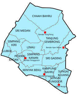
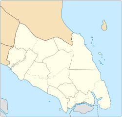
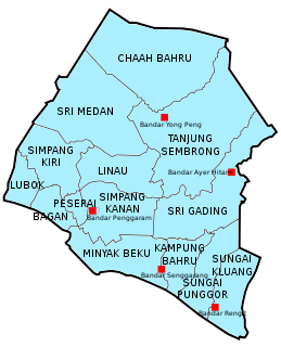
The Batu Pahat District is a district in the state of Johor, Malaysia. It lies southeast of Muar, southwest of Kluang, northwest of Pontian, south of Segamat and Tangkak District. The capital of the district is Bandar Penggaram.

The Segamat District is a district located north of the state of Johor in Malaysia. The district capital is Segamat Town. In fact, local folklore says Segamat is a derivative of "Segar Amat" with the words spoken by Bendahara Tepok Bendahara of Sultanate of Malacca as he approached Segamat River to have some fresh drinks. It is not known when the name Segamat was used, but before the town of Segamat became known as Segamat, it was known as the Rantau Panjang. Rantau Panjang location is believed to be located on the banks of the Segamat river starting from the old Kuala Segamat River across the railway about length 1 km.
Yong Peng is a town in Mukim Tanjung Semberong, Batu Pahat District, Johor, Malaysia. It has an area of 1911.6 hectares with an estimated population of 29,046.

Rengit is a town and an autonomous sub-district in Mukim Sungai Kluang, Batu Pahat District, Johor, Malaysia. Rengit has more than 30 villages and 25 schools.

Parit Raja is a town in Batu Pahat District, Johor, Malaysia. The main population of this town has been Javanese. They all are diligent. For those who never put their feet on this town. They should, they must, because this town is full of flavour. Lots of roadside stall which is give you so many varieties of food you want to choose. Not to mention pasar isnin khamis, pasar rabu, pasar karat vintage things sales here, MS downtown main event place for Downtown Street Market and lots more thrift stuff in here. In recent years, the town has seen substantial growth due to the rapid expansion of Universiti Tun Hussein Onn Malaysia (UTHM), or Tun Hussein Onn University of Malaysia, located here. Because of that, most people from this town, self upgrade them self to be more creative, more innovative, more up-to-date and always looking for opportunities that they have to make this town to be known as now.

Chaah is a town and mukim in Segamat District, Johor, Malaysia. It is the southernmost mukim in the district, but it is administered as a suburb of Labis.

The Bandar Baharu District is a town, district and state assembly constituency at the southernmost end of Kedah, Malaysia. Bandar Baharu is located along the Kedah-Penang–Perak border tripoint, 37 km (23 mi) southeast of George Town, Penang's capital city.

Floods in Malaysia are regular natural disasters which happen nearly every year especially during the monsoon season. The east coast of peninsular Malaysia is the most prone to flooding especially during the northeast monsoon season from October to March.

Sri Gading or Seri Gading is a mukim and parliamentary constituency in Batu Pahat District, Johor, Malaysia, located along Jalan Batu Pahat-Kluang. It lies south-east of Batu Pahat town, north-west of Ayer Hitam and west of Yong Peng. It is also a name of one of 14 parishes in Johor, Sri Gading parish.

The Muar District is a district in Johor, Malaysia. Muar is located at the mouth of the Muar River, on the coast of the Straits of Malacca. The Muar District covers 1,354 km2 (523 sq mi), with a population of 233,779 (2010).
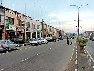
Batu Pahat (BP) is a city and capital of Batu Pahat District, Johor, Malaysia. It lies south-east of Muar, south-west of Kluang, north-west of Pontian and south of Segamat. The town area is located inside Simpang Kanan parishes.

Batu Pahat Municipal Council is a local authority which administrates West Batu Pahat District in Johor, Malaysia. This agency is under Johor state government. MPBP are responsible for public health and sanitation, waste removal and management, town planning, environmental protection and building control, social and economic development and general maintenance functions of urban infrastructure. The MPBP main headquarters is located at Jalan Pejabat, Bandar Penggaram, Batu Pahat.

Linau Mukim is a mukim located in Batu Pahat district in Johor. Batu Pahat district is divided into 14 parishes, each of which encompasses several villages.
Sungai Panjang is a state constituency in Selangor, Malaysia, that has been represented in the Selangor State Legislative Assembly since 1974.
Mukim Kampung Bahru or Kampong Bahru is a mukim located in Batu Pahat District in Johor, Malaysia. Batu Pahat District was divided into 14 mukims, each of which encompasses several villages. The population was 11,997 in 2010. The majority ethics of the population in the Kampung Bahru is Malay (9,286).
Mukim Sungai Punggor or Sungai Punggur is a mukim located in Batu Pahat District in Johor, Malaysia. Batu Pahat District was divided into 14 mukims, each of which encompasses several villages. The population was 10,417 in 2010. The majority ethics of the population in the Sungai Punggor is Malay (8,887). The nearby towns is Bandar Rengit (east) and Bandar Senggarang (west).