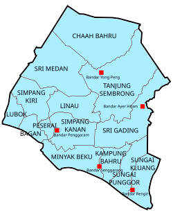
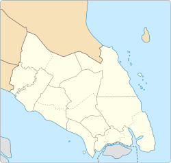
The Batu Pahat District is a district in the state of Johor, Malaysia. It lies southeast of Muar, southwest of Kluang, northwest of Pontian, south of Segamat and Tangkak District. The capital of the district is Bandar Penggaram.

The Segamat District or simply Segamat is a district in the Malaysian state of Johor. Segamat is also the name of the district's primary town.

Mersing is a town, mukim and the capital of Mersing District, Johor, Malaysia.

Labis is town and a mukim (township) in Segamat District in northern Johor, Malaysia. A main trunk road that runs north-south Peninsular Malaysia passes through it, as well as the KTM railway line that connects it with the state's capital in the south, Johor Bahru.

Perak Tengah District is a district in Perak, Malaysia. It is administered by the Perak Tengah District Council, which is based at the town of Seri Iskandar; Parit is however the largest settlement in the area.

Pontian District is a district located in southwest part of the Malaysian state of Johor. It borders Batu Pahat and Kluang Districts to the north and Kulai and Johor Bahru Districts to the east.
Yong Peng is a town in Mukim Tanjung Semberong, Batu Pahat District, Johor, Malaysia. It has an area of 1911.6 hectares with an estimated population of 29,046.

Rengit is a town and an autonomous sub-district in Mukim Sungai Kluang, Batu Pahat District, Johor, Malaysia. Rengit has more than 30 villages and 25 schools.

Parit Raja is a town in Batu Pahat District, Johor, Malaysia. The main population of this town and its surrounding areas has been resided by Malay with Javanese descent, besides the Chinese population. This locality has a unique diversification spanning from foods and cultures. There is lots of restaurant that serves Indian Muslim, Chinese, Southern Malay and Northern Malay cuisines. This locality also being as an important marketplace, few examples are, Pasar Isnin-Khamis, Pasar Rabu, making it a hotspot for local farmers, street food hawkers and commercial businesses. In recent years, the town has seen substantial growth due to the rapid expansion of Universiti Tun Hussein Onn Malaysia (UTHM) and a few other higher education campuses. Because of that, Parit Raja observes a rapid growth in economic and social quality. Parit Raja also has been entitled as an education hub for the southern state of Johor

Floods in Malaysia are one of the most regular natural disasters affecting the country, which occurs nearly every year especially during the monsoon season. The coasts of peninsular Malaysia are the most prone to flooding especially during the northeast monsoon season from October to March.

Sri Gading or Seri Gading is a mukim and parliamentary constituency in Batu Pahat District, Johor, Malaysia, located along Jalan Batu Pahat-Kluang. It lies south-east of Batu Pahat town, north-west of Ayer Hitam and west of Yong Peng. It is also a name of one of 14 parishes in Johor, Sri Gading parish.

The Kulai District is a district in the state of Johor, Malaysia. Its district capital is Kulai Town. It covers Kulai Town, Ayer Bemban, Bandar Putra Kulai, Bukit Batu, Indahpura, Bandar Baru Kangkar Pulai, Kelapa Sawit, Saleng, Sedenak, Seelong, Senai, and Sengkang. Kulai is also within Iskandar Malaysia economic zone.

The Muar District is a district in Johor, Malaysia. Muar is located at the mouth of the Muar River, on the coast of the Straits of Malacca. The Muar District covers 1,354 km2 (523 sq mi), with a population of 233,779 (2010).
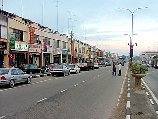
Batu Pahat (BP) is a town and capital of Batu Pahat District, Johor, Malaysia. It lies south-east of Muar, south-west of Kluang, north-west of Pontian and south of Segamat. The town area is located inside Simpang Kanan parishes.

Kota Tinggi District is a district in the Malaysian state of Johor. It is the largest district in the state with an area of 3,488.7 square kilometres (1,347.0 sq mi). The population was 187,824 in 2010. The principal town is Kota Tinggi.

Linau Mukim is a mukim located in Batu Pahat district in Johor. Batu Pahat district is divided into 14 parishes, each of which encompasses several villages.
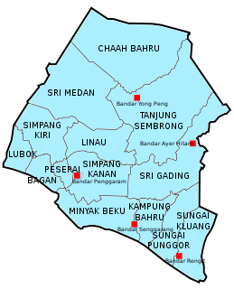
Mukim Sungai Punggor or Sungai Punggur is a mukim located in Batu Pahat District in Johor, Malaysia. Batu Pahat District was divided into 14 mukims, each of which encompasses several villages. The population was 10,417 in 2010. The majority ethics of the population in the Sungai Punggor is Malay (8,887). The nearby towns is Bandar Rengit (east) and Bandar Senggarang (west).
Mukim Sungai Kluang or Sungai Keluang is a mukim located in Batu Pahat District in Johor, Malaysia. Batu Pahat District was divided into 14 mukims, each of which encompasses several villages. The population was 16,591 in 2010. The majority ethics of the population in the Sungai Kluang is Malay (11,854). It border with Mukim Benut, Pontian District in east and Mukim Sungai Punggor in west.