
Kota Kinabalu, colloquially referred to as KK, is the state capital of Sabah, Malaysia. It is also the capital of the Kota Kinabalu District as well as the West Coast Division of Sabah. The city is located on the northwest coast of Borneo facing the South China Sea. The Tunku Abdul Rahman National Park lies to its west and Mount Kinabalu, which gave the city its name, is located to its east. Kota Kinabalu has a population of 452,058 according to the 2010 census; when the adjacent Penampang and Tuaran districts are included, the metro area has a combined population of 628,725. The 2020 Census revealed an increase in the municipal population to 500,421, while the wider area including the Penampang and Putatan districts had a population of 731,406.

Kudat is the capital of the Kudat District in the Kudat Division of Sabah, Malaysia. Its population was estimated to be around 29,025 in 2010. It is located on the Kudat Peninsula, about 190 kilometres (120 mi) north of Kota Kinabalu, the state capital, and is near the northernmost point of Borneo. It is the largest town in the heartland of the Rungus people which is a sub-ethnic group of the majority Kadazan-Dusun race and is therefore a major centre of Rungus culture. It is also notable for being one of the first parts of Sabah to be settled by Chinese Malaysians, particularly from the Hakka dialect group. It is the Northernmost Malaysian city.
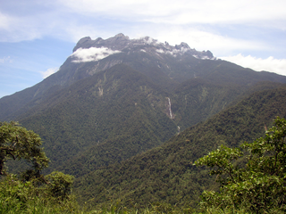
Kinabalu Park, established as one of the first national parks of Malaysia in 1964, is Malaysia's first World Heritage Site designated by UNESCO in December 2000 for its "outstanding universal values" and the role as one of the most important biological sites in the world with more than 4,500 species of flora and fauna, including 326 bird and around 100 mammal species, and over 110 land snail species.

Lawas is a small town and the capital of Lawas District, Limbang Division, Sarawak, Malaysia. This district area is 3,811.90 square kilometres, and population was 46,200. It is 1,200 km from the state capital, Kuching and 200 km from the capital city of Sabah, Kota Kinabalu.

West Coast Division is an administrative division of Sabah, Malaysia. It occupies the northwest portion of Sabah. With an area of 7,588 square kilometres, it occupies 10.3% of Sabah's territory. It also has approximately 30% of Sabah's total population, with the main indigenous inhabitants comprising the Bajau, Bisaya, Bruneian Malay, Dusun, Illanun, Kadazan and Kedayan, as well with a significant numbers of Chinese. The division is divided into the districts of Ranau, Kota Belud, Tuaran, Penampang, Papar, and the state capital Kota Kinabalu. The main towns are as in the names of the districts, plus other towns including Putatan, Inanam, Telipok, Tamparuli, Tenghilan and Kinarut.

Tuaran is the capital of the Tuaran District in the West Coast Division of Sabah, Malaysia. Its population was estimated to be around 128,200 in 2019 with half the population consisting of ethnic Dusuns, most of the Lotud ethnic subgroup as well of Bajau descent. The remainder is mostly of the Malaysian Chinese community, particularly from the Hakka subgroup and Malay. The town is bordered on three sides by the Tuaran River. It is located 34 kilometres (21 mi) north of the state capital Kota Kinabalu, and is strategically situated along the main highway linking Kota Kinabalu with the north of Sabah.

Kota Belud is the capital of the Kota Belud District in the West Coast Division of Sabah, Malaysia. Its population was estimated to be around 8,392 in 2010. It is roughly at the midpoint of the federal highway connecting the state capital, Kota Kinabalu, and Kudat, near the northern tip of Sabah. The town is considered as the unofficial capital and gateway to the heartland of the West Coast Bajau people.

Papar is the capital of the Papar District in the West Coast Division of Sabah, Malaysia. Its population was estimated to be around 124,420 in 2010, which is divided between Bruneian Malay, Kadazan-Dusun, and Bajau. There is also a sizeable Chinese minority, predominantly of the Hakka subgroup, as well as smaller numbers of other races. The town is located 38 kilometres south of the state capital of Kota Kinabalu, with the Papar railway station in the town becoming one of the main stops of the Sabah State Railway.

Mount Tambuyukon or Tamboyukon is a mountain located at the West Coast and Kudat divisions of Sabah, Malaysia. It is considered the third-highest mountain in the country with height at 2,579 metres (8,461 ft), lying north of the highest Mount Kinabalu.

Kundasang is a hill station in the district of Ranau in Sabah, Malaysia that lies along the bank of Kundasang Valley within the Crocker Range, and also neighboring the town of Pekan Nabalu. It is located about 6 kilometres away from Kinabalu National Park, 15.6 kilometres from Ranau town and is renowned for its vegetable market which is open seven days a week. It is the closest town to Mount Kinabalu and has a panoramic view of the mountain. It is populated mainly by the native Dusun and a small population of Chinese people. Almost all the shops are operated by locals.

Tamparuli is a small town and a sub-district of Tuaran on the west coast of Sabah, Malaysia located just off the Kota Kinabalu - Sandakan road, making it a stop for a snack or meal for travelers taking this route from the direction of Kota Kinabalu. The town is also a stop en route to the town of Kiulu, a whitewater rafting destination for domestic and foreign tourists. It is populated mainly by native Dusuns, while a sizeable Chinese community runs most of the shops in the town proper.

Gaya Island is a sizeable Malaysian island of 1,465 ha, just 10 minutes off Kota Kinabalu, Sabah and forms part of the Tunku Abdul Rahman National Park. Gaya Island derived its name from the word "Gayo" which means big in both the Kadazandusun and Bajau languages and occupies an area of 15 km2 with an elevation of up to 300 metres. Several ridges rise more than 600 feet, peaking at 1,000 feet, along the backbone of Gaya Island.

Bongawan is a town in the West Coast Division of the state of Sabah in Malaysia. It is situated within the parliamentary constituency of Kimanis. The town center is 3 kilometers inland from the South China Sea and approximately 70 kilometers south of Kota Kinabalu, the state capital. It is located on the A2 highway connecting Kota Kinabalu and the southern part of Sabah, and Bongawan railway station is one of the stops for Sabah State Railway.

The Roman Catholic Archdiocese of Kota Kinabalu is a metropolitan archdiocese of the Latin Church of the Roman Catholic Church in Sabah, Malaysia, on the island of Borneo. The archdiocese is the oldest ecclesiastical territory in Malaysia, with a long history slowly rising along with the Catholic population from a prefecture to an archdiocese. Its cathedral archepiscopal see is Sacred Heart Cathedral, Kota Kinabalu. The patron saint of the archdiocese is St. Joseph, Spouse of the Blessed Virgin Mary.

The Kota Belud District is an administrative district in the Malaysian state of Sabah, part of the West Coast Division which includes the districts of Kota Belud, Kota Kinabalu, Papar, Penampang, Putatan, Ranau and Tuaran. The capital of the district is in Kota Belud Town.

The Papar District is an administrative district in the Malaysian state of Sabah, part of the West Coast Division which includes the districts of Kota Belud, Kota Kinabalu, Papar, Penampang, Putatan, Ranau and Tuaran. The capital of the district is in Papar Town.

The Penampang District is an administrative district in the Malaysian state of Sabah, part of the West Coast Division which includes the districts of Kota Belud, Kota Kinabalu, Papar, Penampang, Putatan, Ranau and Tuaran. The capital of the district is in Penampang Town.

Tenghilan is a small town and mukim under the administration of the Tamparuli minor district office. It is located in the Tuaran District of the West Coast Division of Sabah, Malaysia. The Tenghilan area is centered around a small town of the same name located near the road that connects Kota Kinabalu and Kota Belud. In 2010, its population was estimated at 203 inhabitants, mostly of Kadazan-Dusun origin. The town, which covers about 400 hectares of land, is located about 17 km northeast of Tuaran, and 25 km southwest of Kota Belud.

Anjung Kinabalu, also known as Anjung Kinabalu KK Night Market, is a Malaysian night market located in Kota Kinabalu, Sabah, East Malaysia, showcasing the culture and foods of Sabah. The market opens as the sun sets. Anjung Kinabalu is also a spot to shop for local handicrafts and souvenirs. The market is particularly popular on weekends.


