| Liwagu River | |
|---|---|
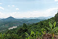
 View of the river. | |
 | |
| Native name | Bawang Liwagu (Kadazan Dusun) |
| Location | |
| Country | |
| State | |
| Division | West Coast Division |
| Precise location | Central northern Borneo |
| Physical characteristics | |
| Source | |
| • location | From the southern slopes of Mount Kinabalu in Ranau District |
| • coordinates | 5°59′38.9″N116°34′09.9″E / 5.994139°N 116.569417°E |
| Mouth | |
• location | Towards Labuk River at Telupid District into Sulu Sea |
• coordinates | 5°53′18.4″N117°30′02.3″E / 5.888444°N 117.500639°E |
• elevation | Sea level |
| Length | 200 km (120 mi) |
| Basin features | |
| River system | Mount Kinabalu |
The Liwagu River (Malay : Sungai Liwagu, Kadazan Dusun : Bawang Liwagu) is a river in West Coast Division of Sabah, Malaysia, flowing eastwards off the southern slope of Mount Kinabalu into the Labuk River in Sandakan Division. Most parts of the river are covered by primary and secondary forests.[ citation needed ]