
Borneo is the third-largest island in the world, with an area of 748,168 km2 (288,869 sq mi). Situated at the geographic centre of Maritime Southeast Asia, it is one of the Greater Sunda Islands, located north of Java, west of Sulawesi, and east of Sumatra.

Sabah is a state of Malaysia located in northern Borneo, in the region of East Malaysia. Sabah has land borders with the Malaysian state of Sarawak to the southwest and Indonesia's North Kalimantan province to the south. The Federal Territory of Labuan is an island just off Sabah's west coast. Sabah shares maritime borders with Vietnam to the west and the Philippines to the north and east. Kota Kinabalu is the state capital and the economic centre of the state, and the seat of the Sabah State government. Other major towns in Sabah include Sandakan and Tawau. The 2020 census recorded a population of 3,418,785 in the state. It has an equatorial climate with tropical rainforests, abundant with animal and plant species. The state has long mountain ranges on the west side which forms part of the Crocker Range National Park. Kinabatangan River, the second longest river in Malaysia runs through Sabah. The highest point of Sabah, Mount Kinabalu is also the highest point of Malaysia.

East Malaysia, or the Borneo States, also known as Malaysian Borneo, is the part of Malaysia on and near the island of Borneo, the world's third-largest island. East Malaysia comprises the states of Sabah, Sarawak, and the Federal Territory of Labuan. The small independent nation of Brunei comprises two enclaves in Sarawak. To the south and southeast is the Indonesian portion of Borneo, Kalimantan. East Malaysia lies to the east of Peninsular Malaysia, the part of the country on the Malay Peninsula. The two are separated by the South China Sea.
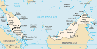
The geography of Malaysia includes both the physical and the human geography of Malaysia, a Southeast Asian country made up of two major landmasses separated by water—Peninsular Malaysia to the west and East Malaysia to the east—and numerous smaller islands that surround those landmasses. Peninsular Malaysia is on the southernmost part of the Malay Peninsula, south of Thailand, north of Singapore and east of the Indonesian island of Sumatra; East Malaysia comprises most of the northern part of Borneo, and shares land borders with Brunei to the north and Indonesian Borneo to the south.

Labuan, officially the Federal Territory of Labuan, is an island federal territory of Malaysia. Its territory includes Labuan Island and six smaller islands, off the coast of the state of Sabah in East Malaysia. Labuan's capital is Victoria and is best known as an offshore financial centre offering international financial and business services via Labuan IBFC since 1990 as well as being an offshore support hub for deepwater oil and gas activities in the region. It is also a tourist destination for people travelling through Sabah, nearby Bruneians and scuba divers. The name Labuan derives from the Malay word labuhan which means harbour.

Kudat is the capital of the Kudat District in the Kudat Division of Sabah, Malaysia. Its population was estimated to be around 29,025 in 2010. It is located on the Kudat Peninsula, about 190 kilometres (120 mi) north of Kota Kinabalu, the state capital, and is near the northernmost point of Borneo. It is the largest town in the heartland of the Rungus people which is a sub-ethnic group of the majority Kadazan-Dusun race and is therefore a major centre of Rungus culture. It is also notable for being one of the first parts of Sabah to be settled by Chinese Malaysians, particularly from the Hakka dialect group. It is the Northernmost Malaysian city.

The North Borneo Chartered Company (NBCC), also known as the British North Borneo Company (BNBC), was a British chartered company formed on 1 November 1881 to administer and exploit the resources of North Borneo. The territory became a protectorate of the British Empire in 1888 but the company remained involved with the territory until 1946, when administration was fully assumed by the Crown colony government.

West Coast Division is an administrative division of Sabah, Malaysia. It occupies the northwest portion of Sabah. With an area of 7,588 square kilometres, it occupies 10.3% of Sabah's territory. It also has approximately 30% of Sabah's total population, with the main indigenous inhabitants comprising the Bajau, Bisaya, Bruneian Malay, Dusun, Illanun, Kadazan and Kedayan, as well with a significant numbers of Chinese. The division is divided into the districts of Ranau, Kota Belud, Tuaran, Penampang, Papar, and the state capital Kota Kinabalu. The main towns are as in the names of the districts, plus other towns including Putatan, Inanam, Telipok, Tamparuli, Tenghilan and Kinarut.

Sabah State Railway is a railway system and operator in the state of Sabah in Malaysia. It is the only rail transport system operating on the island of Borneo. The railway consists of a single 134-kilometre line from Tanjung Aru, Kota Kinabalu in West Coast Division to the town of Tenom, in the Interior Division. It was formerly known as North Borneo Railway.

The Pan-Borneo Highway including the sections now known as the Pan Borneo Expressway, is a controlled-access highway on Borneo Island, connecting two Malaysian states, Sabah and Sarawak, with Brunei. The length of the entire highway is 2,083 kilometres (1,294 mi) for the Malaysian section, 168 kilometres (104 mi) for the Bruneian section.

Kimanis is a town and also a parliamentary constituency in Papar District, West Coast Division of Sabah, Malaysia. It is located approximately 45 kilometres south of the city of Kota Kinabalu, halfway between Papar and Beaufort.

The history of Sabah can be traced back to about 23–30,000 years ago when evidence suggests the earliest human settlement in the region existed. The history is interwoven with the history of Brunei and the history of Malaysia, which Sabah was previously part of and is currently part of respectively. The earliest recorded history of Sabah being part of any organised civilisation began in the early 15th century during the thriving era of the Sultanate of Brunei. Prior to this, early inhabitants of the land lived in predominantly tribal societies, although such tribal societies had continued to exist until the 1900s. The eastern part of Sabah was ceded to the Sultan of Sulu by the Sultan of Brunei in 1658 for the former helping a victory over Brunei enemies, but many sources stated it had not been ceded at all. By the late 19th century, both territories previously owned by Sultan of Brunei and Sultan of Sulu was granted to British syndicate and later emerged as British North Borneo under the management of the North Borneo Chartered Company. Sabah became a protectorate of the United Kingdom in 1888 and subsequently became a Crown colony from 1946 until 1963, during which time it was known as Crown Colony of North Borneo. On 16 September 1963, Sabah merged with Malaya, Sarawak and Singapore to form Malaysia.

Greater Kota Kinabalu refers to the dense clusters of regional populated areas surrounding the city of Kota Kinabalu in Malaysia. It comprises the districts of Kota Kinabalu, Penampang, Tuaran and Papar. These districts are also part of the West Coast Division. It was forecasted that in 2019, the combined population of these districts was 1.1 million people, in a combined area of 3,277 km2.

Sabah Oil and Gas Terminal (SOGT) is a terminal located in Kimanis, Papar District, Sabah, Malaysia. The terminal handles the production of oil and gas from the West Coast Field in South China Sea facing the western coast of Sabah, which covering the operations of Sabah Gas Terminal, Labuan Crude Oil Terminal and the Labuan Gas Terminal. Covering an area of about 250 acres, with a capacity to handle up to 300,000 barrels of crude oil per day and 1.0 billion standard cubic feet of gas per day. The terminal stores oil before it is transported by tanker. The terminal is also connected to another terminal in neighbouring Sarawak through the Sabah–Sarawak Gas Pipeline.

The Sipitang District is an administrative district in the Malaysian state of Sabah, part of the Interior Division which also includes the districts of Beaufort, Keningau, Kuala Penyu, Nabawan, Tambunan and Tenom. The capital of the district is in Sipitang Town. The ecotourism village of Long Mio and Long Pasia is located in this district, while the small town of Sindumin serves as a gateway to the state of Sarawak.

The Kota Kinabalu District is an administrative district in the Malaysian state of Sabah, part of the West Coast Division which includes the districts of Kota Belud, Kota Kinabalu, Papar, Penampang, Ranau and Tuaran. The capital of the district is in Kota Kinabalu City.

The Papar District is an administrative district in the Malaysian state of Sabah, part of the West Coast Division which includes the districts of Kota Belud, Kota Kinabalu, Papar, Penampang, Putatan, Ranau and Tuaran. The capital of the district is in Papar Town.

The Putatan district is an administrative district in the Malaysian state of Sabah, part of the West Coast Division which includes the districts of Kota Belud, Kota Kinabalu, Papar, Penampang, Ranau and Tuaran. The capital of the district is in Putatan Town.

The Papar River is a river in West Coast Division, northwestern Sabah of Malaysia. It has a total length of 60 km from its headwaters in the mountains of northwest Sabah to its outlet at the South China Sea, northwest of Papar town. It originates in the mountains in the interior Papar, Penampang and Tuaran Districts, which form part of the Crocker Range system. This includes the areas of Babagon, Bonobukan, Buayan, Central Papar, Gramatoi, Himpangno, Kaiduan, Kalangan, Kawari, Kogopon, Lingan, Mandalipau, Marahang, Padawan, Terian, Tiku and Ulu Papar.
Schomburgk Bay is a bay on the northern coast of the island of Borneo. It is located in the Malaysian state of Sabah and borders the Sulu Sea. Administratively, it is a part of Beluran District in Sandakan Division.


