
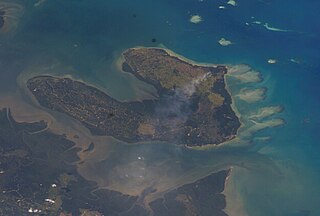
Sebatik Island is an island off the eastern coast of Borneo, partly within Indonesia and partly within Malaysia. It is one of the 92 officially listed outlying islands of Indonesia.

Sandakan formerly known at various times as Elopura, is the capital of the Sandakan District in Sabah, Malaysia. It is the second largest city in Sabah after Kota Kinabalu. It is located on the Sandakan Peninsula and east coast of the state in the administrative centre of Sandakan Division and was the former capital of British North Borneo. In 2010, the city had an estimated population of 157,330 while the overall municipal area had a total population of 396,290. The population of the municipal area had increased to 439,050 by the 2020 Census.
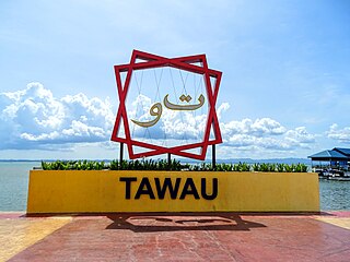
Tawau, formerly known as Tawao, is the capital of the Tawau District in Sabah, Malaysia. It is the third-largest city in Sabah, after Kota Kinabalu and Sandakan. It is located on the Semporna Peninsula in the southeast coast of the state in the administrative centre of Tawau Division, which is bordered by the Sulu Sea to the east, the Celebes Sea to the south at Cowie Bay and shares a border with North Kalimantan, Indonesia. The town had an estimated population as of 2010, of 113,809, while the whole municipality area had a population of 397,673. The municipal area had a population of 372,615 at the 2020 Census.

The North Borneo Chartered Company (NBCC), also known as the British North Borneo Company (BNBC) was a British chartered company formed on 1 November 1881 to administer and exploit the resources of North Borneo. The territory became a protectorate of the British Empire in 1888 but the company remained involved with the territory until 1946, when administration was fully assumed by the Crown colony government.
The Mat Salleh Rebellion was a series of major armed disturbances against the British North Borneo Chartered Company administration in North Borneo, now the Malaysian state of Sabah. It was instigated by Datu Muhammad Salleh, a local chief from the Lingkabo district and Sugut River. He led the rebellion between 1894 until his death in Tambunan in 1900. The rebellion then continued on for another five years until 1905.

Kudat Division is an administrative division in the state of Sabah, Malaysia. It occupies the northern tip of Sabah. Its total area of 4,623 square kilometres makes it the smallest of the five divisions of Sabah. The division covers the districts of Kudat, Pitas and Kota Marudu, as well as the islands of Balak, Balambangan, Banggi, Bankawan, Guhuan Utara, Kalampunian and Malawali.
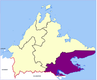
Tawau Division is one of the five administrative sub-divisions of Sabah, Malaysia. It occupies a total of 14,905 square kilometres or 20% of Sabah's territory. The main towns include the capital of Tawau, Lahad Datu, Kunak and Semporna. Tawau division has 26% of Sabah's total population, with the main indigenous groups consisting of the Bajau, Suluk, Ida'an, Tidong, Cocos, Murut, Lun Bawang/Lun Dayeh as well as a minority of mixed ethnic groups. Large numbers of both legal and illegal immigrants from Indonesia such as the Buginese and Torajans, from East Timor the Timorese, from the Philippines the Tausūg and Visayans as well South and West Asian immigrants such as Pakistanis, Indians and Arabs can be found in this area. As with the rest of Sabah, the division also has large numbers of ethnic Chinese.

Tawau Airport is an airport located 15 nautical miles north east of Tawau, Sabah, Malaysia. It is one of two airports in Sabah with immigration counters for international flights, the other being Kota Kinabalu International Airport. Tawau Airport serves the districts of Tawau, Kunak and Semporna and is the nearest airport to the diving islands of Sipadan, Mabul and Kapalai, all of which are located in the latter district.

Darvel Bay or Lahad Datu Bay is a bight on the east side of Sabah, Malaysia. It is the largest semi-enclosed bay on the east coast of Borneo and faces the Sulawesi Sea. Administratively, it is within Tawau Division, with Lahad Datu District on the north side, Kunak District in the middle and Semporna District to the south of the bay.

The Crown Colony of North Borneo was a Crown colony on the island of Borneo established in 1946 shortly after the dissolution of the British Military Administration. The Crown Colony of Labuan joined the new Crown Colony during its formation. It was succeeded as the state of Sabah through the formation of the Federation of Malaysia on 16 September 1963.

In April 1963, the first recorded infiltration and attack occurred in Borneo as part of the wider Indonesia–Malaysia confrontation. An infiltration force training at Nangabadan was split in two and prepared for its first operation. On 12 April 1963, one infiltration force attacked and seized the police station at Tebedu in the 1st Division of Sarawak, about 40 miles (64 km) from Kuching and 2 miles (3.2 km) from the border with Kalimantan. The other group attacked the village of Gumbang, South West of Kuching, later in the month. Only about half returned. Confrontation could be said to have started from a military perspective with the Tebedu attack.

Alexander Rankin Dunlop was the first British Resident in Tawau of North Borneo.

The Sandakan District is an administrative district in the Malaysian state of Sabah, part of the Sandakan Division which includes the districts of Beluran, Kinabatangan, Sandakan, Telupid, and Tongod. The capital of the district is in Sandakan City.
The Kunak District is an administrative district in the Malaysian state of Sabah, part of the Tawau Division which includes the districts of Kunak, Lahad Datu, Semporna and Tawau. The capital of the district is in Kunak Town. Kunak district were part of Lahad Datu before 1990.

The Lahad Datu District is an administrative district in the Malaysian state of Sabah, part of the Tawau Division which includes the districts of Kunak, Lahad Datu, Semporna and Tawau. The capital of the district is in Lahad Datu Town.

The Semporna District is an administrative district in the Malaysian state of Sabah, part of the Tawau Division which includes the districts of Kunak, Lahad Datu, Semporna and Tawau. The capital of the district is in Semporna Town.

The Tawau District is an administrative district in the Malaysian state of Sabah, part of the Tawau Division which also includes the districts of Kunak, Lahad Datu, Semporna and Tawau. The capital of the district is in Tawau Town. The district also includes the northern half of Sebatik Island, which is shared with Indonesia's North Kalimantan province.
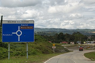
Kalabakan is a district in the Malaysian state of Sabah, located approximately 235 kilometres (146 mi) southeast of the state capital of Kota Kinabalu. It recorded a population of 48,195 people in the 2020 Malaysian census. Its capital is the town of Kalabakan.
Schomburgk Bay is a bay on the northern coast of the island of Borneo. It is located in the Malaysian state of Sabah and borders the Sulu Sea. Administratively, it is a part of Beluran District in Sandakan Division.


