
Borneo is the third-largest island in the world, with an area of 748,168 km2 (288,869 sq mi). Situated at the geographic centre of Maritime Southeast Asia, it is one of the Greater Sunda Islands, located north of Java, west of Sulawesi, and east of Sumatra.
Lahad Datu is the capital of the Lahad Datu District in the Dent Peninsula on Tawau Division of Sabah, Malaysia. Its population was estimated to be around 27,887 in 2010. The town is surrounded by stretches of cocoa and palm oil plantations. It is also an important timber exporting port. The town has an airport for domestic flights.

Sandakan formerly known at various times as Elopura, is the capital of the Sandakan District in Sabah, Malaysia. It is the second largest city in Sabah after Kota Kinabalu. It is located on the Sandakan Peninsula and east coast of the state in the administrative centre of Sandakan Division and was the former capital of British North Borneo. In 2010, the city had an estimated population of 157,330 while the overall municipal area had a total population of 396,290. The population of the municipal area had increased to 439,050 by the 2020 Census.
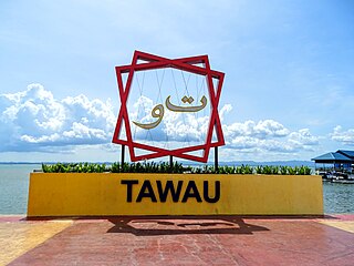
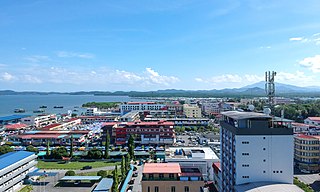
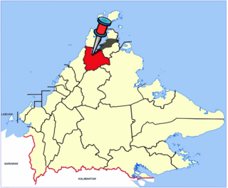
Tawau, formerly known as Tawao, is the capital of the Tawau District in Sabah, Malaysia. It is the third-largest city in Sabah, after Kota Kinabalu and Sandakan. It is located on the Semporna Peninsula in the southeast coast of the state in the administrative centre of Tawau Division, which is bordered by the Sulu Sea to the east, the Celebes Sea to the south at Cowie Bay and shares a border with North Kalimantan, Indonesia. The town had an estimated population as of 2010, of 113,809, while the whole municipality area had a population of 397,673. The municipal area had a population of 372,615 at the 2020 Census.

The North Borneo Chartered Company (NBCC), also known as the British North Borneo Company (BNBC), was a British chartered company formed on 1 November 1881 to administer and exploit the resources of North Borneo. The territory became a protectorate of the British Empire in 1888 but the company remained involved with the territory until 1946, when administration was fully assumed by the Crown colony government.

The Mat Salleh Rebellion was a series of major armed disturbances against the British North Borneo Chartered Company administration in North Borneo, now the Malaysian state of Sabah. It was instigated by Datu Muhammad Salleh, a local chief from the Lingkabo district and Sugut River. He led the rebellion between 1894 until his death in Tambunan in 1900. The rebellion then continued on for another five years until 1905.

Semporna is the capital of the Semporna District in the Tawau Division of Sabah, Malaysia. Its population was estimated to be around 35,301 in 2010.

The North Borneo dispute, also known as the Sabah dispute, is the territorial dispute between Malaysia and the Philippines over much of the eastern part of the state of Sabah. Sabah was previously known as North Borneo prior to the formation of the Malaysian federation.

The history of Sabah can be traced back to about 23–30,000 years ago when evidence suggests the earliest human settlement in the region existed. The history is interwoven with the history of Brunei and the history of Malaysia, which Sabah was previously part of and is currently part of respectively. The earliest recorded history of Sabah being part of any organised civilisation began in the early 15th century during the thriving era of the Sultanate of Brunei. Prior to this, early inhabitants of the land lived in predominantly tribal societies, although such tribal societies had continued to exist until the 1900s. The eastern part of Sabah was ceded to the Sultan of Sulu by the Sultan of Brunei in 1658 for the former helping a victory over Brunei enemies, but many sources stated it had not been ceded at all. By the late 19th century, both territories previously owned by Sultan of Brunei and Sultan of Sulu was granted to British syndicate and later emerged as British North Borneo under the management of the North Borneo Chartered Company. Sabah became a protectorate of the United Kingdom in 1888 and subsequently became a Crown colony from 1946 until 1963, during which time it was known as Crown Colony of North Borneo. On 16 September 1963, Sabah merged with Malaya, Sarawak and Singapore to form Malaysia.

William Clark Cowie was a Scottish engineer, mariner, and businessman who helped establish British North Borneo and was Chairman of the British North Borneo Company.
The Western Sabah Railway Line in Sabah, Malaysia is the name given to rail services that operate from Tanjung Aru until Tenom in the West Coast and Interior divisions under the management of Sabah State Railway. The line previously known as North Borneo Railway Line.

The Kuala Penyu District is an administrative district in the Malaysian state of Sabah, part of the Interior Division which includes the districts of Beaufort, Keningau, Kuala Penyu, Nabawan, Sipitang, Tambunan and Tenom. The capital of the district is in Kuala Penyu Town.

The Kudat District is an administrative district in the Malaysian state of Sabah, part of the Kudat Division which includes the districts of Kota Marudu, Kudat and Pitas. The capital of the district is in Kudat Town.
The Kota Marudu District is an administrative district in the Malaysian state of Sabah, part of the Kudat Division which includes the districts of Kota Marudu, Kudat and Pitas. The capital of the district is in Kota Marudu Town.

The Beluran District is an administrative district in the Malaysian state of Sabah, part of the Sandakan Division which includes the districts of Beluran, Kinabatangan, Sandakan, Telupid and Tongod. The capital of the district is in Beluran Town.

The Kinabatangan District is an administrative district in the Malaysian state of Sabah, part of the Sandakan Division which includes the districts of Beluran, Kinabatangan, Sandakan, Telupid and Tongod. The capital of the district is in Kinabatangan Town.

The Lahad Datu District is an administrative district in the Malaysian state of Sabah, part of the Tawau Division which includes the districts of Kunak, Lahad Datu, Semporna and Tawau. The capital of the district is in Lahad Datu Town.

Cowie Bay is a bay on the east coast of the island of Borneo. It is a part of the Malaysian state of Sabah and flows into the Celebes Sea. Administratively, it belongs to the Tawau District in the Tawau Division.

Marudu Bay is a large bay on the north coast of the island of Borneo. It is located in the state of Sabah, Malaysia and opens to the Sulu Sea. Administratively, it is a part of Kudat Division. Kota Marudu District is on the south side of the bay, Kudat District on the west and Pitas District on the east side.
Kimanis Bay is a bay on the west coast of the island of Borneo. It is a part of Malaysian state of Sabah and connects to the South China Sea. Administratively, it belongs to Papar District in the West Coast Division.


