
Sabah is a state of Malaysia located in northern Borneo, in the region of East Malaysia. Sabah has land borders with the Malaysian state of Sarawak to the southwest and Indonesia's North Kalimantan province to the south. The Federal Territory of Labuan is an island just off Sabah's west coast. Sabah shares maritime borders with Vietnam to the west and the Philippines to the north and east. Kota Kinabalu is the state capital and the economic centre of the state, and the seat of the Sabah State government. Other major towns in Sabah include Sandakan and Tawau. The 2020 census recorded a population of 3,418,785 in the state. It has an equatorial climate with tropical rainforests, abundant with animal and plant species. The state has long mountain ranges on the west side which forms part of the Crocker Range National Park. Kinabatangan River, the second longest river in Malaysia runs through Sabah. The highest point of Sabah, Mount Kinabalu is also the highest point of Malaysia.

Ligitan is a small island in Tawau, Sabah, located east of the island of Borneo, in the Celebes Sea. In the past, the island was at the centre of a territorial dispute between Malaysia and Indonesia. The matter was brought for adjudication before the International Court of Justice and, at the end of 2002, the Court awarded the island along with the island of Sipadan to Malaysia, on the basis of the "effective occupation" displayed by the latter's predecessor and the absence of any other superior title. The Philippines had applied to intervene in the proceedings on the basis of its claim to Northern Borneo, but its request was turned down by the Court early in 2001.

The Mat Salleh Rebellion was a series of major armed disturbances against the British North Borneo Chartered Company administration in North Borneo, now the Malaysian state of Sabah. It was instigated by Datu Muhammad Salleh, a local chief from the Lingkabo district and Sugut River. He led the rebellion between 1894 until his death in Tambunan in 1900. The rebellion then continued on for another five years until 1905.

The North Borneo dispute, also known as the Sabah dispute, is the territorial dispute between Malaysia and the Philippines over much of the eastern part of the state of Sabah. Sabah was previously known as North Borneo prior to the formation of the Malaysian federation.

Kadazandusun are the largest ethnic group in Sabah, Malaysia, an amalgamation of the closely related indigenous Kadazan and Dusun peoples. "Kadazandusun" is an umbrella term that encompasses both the Kadazan and Dusun peoples. They are also known as Mamasok Sabah, meaning "indigenous people of Sabah". Kadazandusun tradition holds that they are the descendants of Nunuk Ragang. Kadazandusun is recognised as an indigenous nation of Borneo with documented heritage by the United Nations Educational, Scientific and Cultural Organization (UNESCO) since 2004. Kadazandusuns are part of the bumiputera in Malaysia having been endowed with rights concerning land, rivers, education and maintaining their own customary laws.

Timbun Mata Island is the largest island on the south side of Darvel Bay, in Semporna, Sabah, Malaysia. It is over 26 kilometres (16 mi) long and almost 10 kilometres (6.2 mi) wide at the widest point. The island is mountainous and was formerly (pre-2000) densely wooded. Mt. Tannabalu, the highest point at 620 metres (2,030 ft), is a conical, extinct volcano located at the centre of the island. A secondary peak, Mt. Sedungal, at the east end of the island rises to 489 metres (1,604 ft). The south side of the island is only separated from the mainland by a shallow channel known as the Trusan Sigalong. It is located at 4°38′25″N118°28′29″E with an area of 114.97 square kilometres (44.39 sq mi).

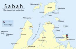
Banggi Island is located in the Kudat Division of Sabah in Malaysia. With an area of 440.7 square kilometres, it is the largest island fully in Malaysia followed by Bruit Island, Langkawi Island and Penang Island. It is located off the northern coast of Sabah near Marudu Bay. The highest elevation on the island is Bukit Sinambung at 529 metres (1,736 ft). As of 2016, it has an estimated population of 30,000. Banggi's largest settlement is Limbuak. In 2014, a new township was proposed to be built in the island. The island is also part of the gazetted area of Tun Mustapha Marine Park.
Malawali is an island in the state of Sabah, Malaysia located in the Sulu Sea. It is located within the Kudat Division, and sits nearby the islands of Banggi and Balambangan. The island is surrounded by coral reefs and is a popular diving spot on the north-east coast of Sabah.
The Roman Catholic Diocese of Sandakan is located in east Malaysia. It is a suffragan diocese of the Archdiocese of Kota Kinabalu. The diocese is subdivided into 5 parishes and 1 mission district.
Terusan is a settlement in Sabah, Malaysia. It is about three feet above sea level, and the approximate population within a seven-kilometer radius was 818 as of 2004.
Dumpas is a Dusunic language of Malaysia.

Larapan Island is a Malaysian island located in the Celebes Sea on the state of Sabah. The island is one of the many islands in Malaysia and has been under Sabah Provincial management of Malaysia. The islands are managed under the Rule and governance of the Malaysian govt.
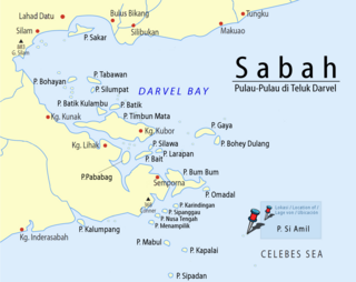
Si Amil Island is a Malaysian island located in the Celebes Sea on the state of Sabah. Si Amil Island is situated northeast of Danawan Island.

Silawa Island is a Malaysian island located in the Celebes Sea on the state of Sabah. The latitude of Silawa Island is 4°34'25.68". The longitude is 118°34'44.05".
Balak Island is an island located near Banggi Island in the Kudat Division on Sabah, Malaysia.
Mengalum Island is an island located on the West Coast Division of Sabah in the South China Sea on Malaysia. The island is among popular destination for Chinese tourists to Sabah.

Beluran is a federal constituency in Sandakan Division, Sabah, Malaysia, that has been represented in the Dewan Rakyat since 1995.
Jambongan was a federal constituency in Sabah, Malaysia, that was represented in the Dewan Rakyat from 1986 to 1995.
Schomburgk Bay is a bay on the northern coast of the island of Borneo. It is located in the Malaysian state of Sabah and borders the Sulu Sea. Administratively, it is a part of Beluran District in Sandakan Division.

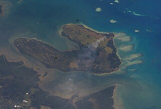
 Jambongan Island seen from satellite