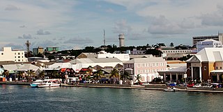
Nassau is the capital and largest city of the Bahamas. It is located on the island of New Providence, which had a population of 246,329 in 2010, or just over 70% of the entire population of the Bahamas. As of April 2023, the preliminary results of the 2022 census of the Bahamas reported a population of 296,522 for New Providence, 74.26% of the country's population. Nassau is commonly defined as a primate city, dwarfing all other towns in the country. It is the centre of commerce, education, law, administration, and media of the country.

Sumbawa is an Indonesian island, located in the middle of the Lesser Sunda Islands chain, with Lombok to the west, Flores to the east, and Sumba further to the southeast. Along with Lombok, it forms the province of West Nusa Tenggara, but there have been plans by the Indonesian government to split the island off into a separate province. Traditionally, the island is known as the source of sappanwood, as well as honey and sandalwood. Its savanna-like climate and vast grasslands are used to breed horses and cattle, as well as to hunt deer.
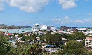
St. John's is the capital and largest city of Antigua and Barbuda, part of the West Indies in the Caribbean Sea. With a population of 22,219, St. John's is the commercial centre of the nation and the chief port of the island of Antigua.

Nassau County is a suburban county located on Long Island, immediately to the east of New York City, bordering the Long Island Sound on the north and the open Atlantic Ocean to the south. As of the 2020 United States census, Nassau County's population was 1,395,774, making it the sixth-most populous county in the State of New York, and reflecting an increase of 56,242 (+4.2%) from the 1,339,532 residents enumerated at the 2010 census. Its county seat is Mineola, while the county's largest and most populous town is Hempstead.

Basseterre is the capital and largest city of Saint Kitts and Nevis with an estimated population of 14,000 in 2018. Geographically, the Basseterre port is located at 17°18′N62°44′W, on the south-western coast of Saint Kitts Island, and it is one of the chief commercial depots of the Leeward Islands. The city lies within Saint George Basseterre Parish.

Bridgetown is the capital and largest city of Barbados. Formerly The Town of Saint Michael, the Greater Bridgetown area is located within the parish of Saint Michael. Bridgetown is sometimes locally referred to as "The City", but the most common reference is simply "Town". As of 2014, its metropolitan population stands at roughly 110,000.
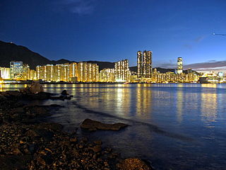
The Eastern District located on northeastern part of Hong Kong Island, being one of the 18 administrative districts of Hong Kong. It had a population of 529,603 in 2021 The district has the second highest population while its residents have the third highest median household income among the 18 districts.

The Toronto Islands are a chain of 15 small islands in Lake Ontario, south of mainland Toronto, Ontario, Canada.
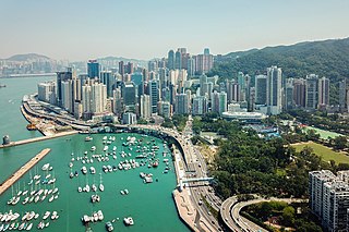
Causeway Bay is an area and a bay on Hong Kong Island, Hong Kong, straddling the border of the Eastern and the Wan Chai districts. It is a major shopping, leisure and cultural centre in Hong Kong, with a number of major shopping centres. The rents in the shopping areas of Causeway Bay were ranked as the world's most expensive for the second year in a row in 2013, after overtaking New York City's Fifth Avenue in 2012. When referring to the area, the Cantonese name is never written in English as "Tung Lo Wan".

Kota Kinabalu, colloquially referred to as KK, is the state capital of Sabah, Malaysia. It is also the capital of the Kota Kinabalu District as well as the West Coast Division of Sabah. The city is located on the northwest coast of Borneo facing the South China Sea. The Tunku Abdul Rahman National Park lies to its west and Mount Kinabalu, which gave the city its name, is located to its east. Kota Kinabalu has a population of 452,058 according to the 2010 census; when the adjacent Penampang and Tuaran districts are included, the metro area has a combined population of 628,725. The 2020 Census revealed an increase in the municipal population to 500,421, while the wider area including the Penampang and Putatan districts had a population of 731,406.

Labuan, officially the Federal Territory of Labuan, is an island federal territory of Malaysia. Its territory includes Labuan Island and six smaller islands, off the coast of the state of Sabah in East Malaysia. Labuan's capital is Victoria and is best known as an offshore financial centre offering international financial and business services via Labuan IBFC since 1990 as well as being an offshore support hub for deepwater oil and gas activities in the region. It is also a tourist destination for people travelling through Sabah, nearby Bruneians and scuba divers. The name Labuan derives from the Malay word labuhan which means harbour.

George Town is the capital and largest city in the Cayman Islands, located on Grand Cayman. As of 2022, the city had a population of 40,957, making it the largest city of all the British Overseas Territories.
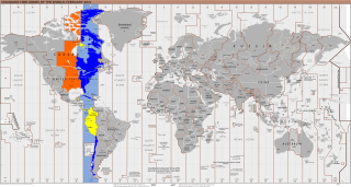
UTC−05:00 is an identifier for a time offset from UTC of −05:00. In North America, it is observed in the Eastern Time Zone during standard time, and in the Central Time Zone during the other eight months. The western Caribbean uses it year round.

The Eastern Suburbs is the eastern metropolitan region of Sydney, New South Wales, Australia.
Redland City, also known as the Redlands and formerly known as Redland Shire, is a local government area (LGA) and a part of Greater Brisbane in South East Queensland, Australia. With a population of 159,222 as of June 2021, Redland City is spread along the southern coast of Moreton Bay, covering 537.2 square kilometres (207.4 sq mi). The city borders the City of Brisbane to the west and north-west and Logan City to the south-west and south, while its islands are situated north of the City of Gold Coast.

Gqeberha, formerly known as Port Elizabeth, and colloquially referred to as P.E., is a major seaport and the most populous city in the Eastern Cape province of South Africa. It is the seat of the Nelson Mandela Bay Metropolitan Municipality, South Africa's second-smallest metropolitan municipality by area. It is the sixth-most populous city in South Africa and is the cultural, economic and financial hub of the Eastern Cape.
Route 1 is a highway in the Canada province of Newfoundland and Labrador, and is the easternmost stretch of the Trans-Canada Highway. Route 1 is the primary east–west road on the island of Newfoundland.

Sepanggar is a sub-district of Kota Kinabalu, Sabah, Malaysia. It is located around Sepanggar Bay which houses the Sepanggar Bay Container Terminal, a major naval base for the Royal Malaysian Navy as well as the Sepanggar Bay Oil Terminal. The main campus for Universiti Malaysia Sabah (UMS), Universiti Teknologi MARA Sabah Branch, Kota Kinabalu Polytechnic and Kota Kinabalu Industrial Park (KKIP) are situated here. Sepanggar is also a parliamentary constituency (P.171) with three state legislative assembly constituencies therein, i.e. Karambunai (N.16), Darau (N.17) and Inanam (N.18).

Telipok is a town located approximately 15 kilometres north of Kota Kinabalu, the state capital of Sabah, Malaysia. The town is within the administration of Kota Kinabalu City Hall and is a sub-district of the city. It is also part of the urban expanse of Kota Kinabalu, and of its metropolitan area. It is situated near Kota Kinabalu Industrial Park, and is within 5 kilometres of the towns of Manggatal, Sepanggar, and Tuaran.

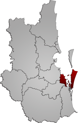
Greater Kota Kinabalu refers to the dense clusters of regional populated areas surrounding the city of Kota Kinabalu in Malaysia. It comprises the districts of Kota Kinabalu, Penampang, Tuaran and Papar. These districts are also part of the West Coast Division. It was forecasted that in 2019, the combined population of these districts was 1.1 million people, in a combined area of 3,277 km2.

