Kapalai

Last updated

Kapalai Island
Sabah-Islands-DarvelBay PulauKapalai-Pushpin.png
Location of Kapalai Island in Darvel Bay
Borneo Locator Topography.png
Red pog.svg
Kapalai Island
Geography
Coordinates 4°13′0″N118°41′0″E / 4.21667°N 118.68333°E / 4.21667; 118.68333
Administration
State Flag of Sabah.svg  Sabah

Kapalai (Malay : Pulau Kapalai) is an island in Tawau Division, Sabah, Malaysia, known for its scuba resorts.

Contents

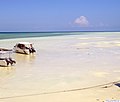
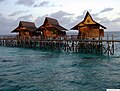
The island of Kapalai, just 15 kilometres off Sipadan, was a beautiful island two hundred years ago, but now remains as only a sand bar. Erosion has reduced the island to sea level and the village now sits on the edge of the extensive Ligitan Reefs. [1] All of the buildings rest on stilts resting on the underwater reef. There is only one private resort on the island, with the rest of the island uninhabited.

Location

Kapalai is situated a couple of hours from the east coast of Borneo. Though the island is a relatively remote location to reach, there are daily flights from Kota Kinabalu, less than a one-hour flight from Tawau.

Transportation

As Kapalai Island is located off the east coast of Sabah / Borneo, Malaysia's easternmost state, direct flights are available to Tawau and Kota Kinabalu on Sabah from Kuala Lumpur on peninsular Malaysia and Singapore. The closest airport to Kapalai is Tawau, located approximately one hour from Semporna's jetty by minivan. Semporna's jetty serves as the speedboat departure point for Kapalai and the neighboring Sipadan Island and Mabul Island.

Kapalai Island is located to the northeast of Sipadan Island. Many tour operators provide roundtrip transfers from Tawau Airport to Semporna and onward to Kapalai Island.

See also

Related Research Articles

<span class="mw-page-title-main">Kota Kinabalu</span> State capital city and district capital in Sabah, Malaysia

Kota Kinabalu, colloquially referred to as KK, is the state capital of Sabah, Malaysia. It is also the capital of the Kota Kinabalu District as well as the West Coast Division of Sabah. The city is located on the northwest coast of Borneo facing the South China Sea. The Tunku Abdul Rahman National Park lies to its west and Mount Kinabalu, which gave the city its name, is located to its east. Kota Kinabalu has a population of 452,058 according to the 2010 census; when the adjacent Penampang and Putatan districts are included, the metro area has a combined population of 628,725. The 2020 Census revealed an increase in the municipal population to 500,421, while the wider area including the Penampang and Putatan districts had a population of 731,406.

<span class="mw-page-title-main">Sabah Parks</span>

Sabah Parks is a conservation-based statutory body established in 1964 with the purpose of conserving the scenic, scientific and historic heritage of the state of Sabah, Malaysia, on the island of Borneo. The organisation is also responsible for the management and promotion of the various protected reserves in Sabah, in particular those designated as national parks. It is also mandated to develop tourism-friendly facilities to accommodate tourist arrivals to these reserves and ensure that the state of the reserves is not compromised. The first choice for inclusion in a park system was Mount Kinabalu. As a result, Kinabalu Park was gazetted in 1964, and today it is designated as a World Heritage Site.

<span class="mw-page-title-main">Sipadan</span> Oceanic island in Malaysia

Sipadan is the only oceanic island in Malaysia, rising 600 metres (2,000 ft) from the seabed. It is located in the Celebes Sea off the east coast of Sabah, Malaysia. It was formed by living corals growing on top of an extinct volcanic cone that took thousands of years to develop. Sipadan is located at the heart of the Indo-Pacific basin, the centre of one of the richest marine habitats in the world. More than 400 species of fish and hundreds of coral species have been classified in this ecosystem. Sipadan Island was at the top of Rodale's Scuba Diving Magazine Gold List for 'The Top Dive Destination in the World'. In fact it shared its top spot with 2 other destinations known for the diversity of their marine life — the Galápagos Islands of Ecuador and Truk in Micronesia. Furthermore, one of the dive operators; Scuba Junkie was voted by the public the "Best Dive Resort in the World 2020" at DiveMagazine's annual Dive Travel Awards.

<span class="mw-page-title-main">Ligitan</span> Island in Malaysia

Ligitan is a small island in Tawau, Sabah, located east of the island of Borneo, in the Celebes Sea. In the past, the island was at the centre of a territorial dispute between Malaysia and Indonesia. The matter was brought for adjudication before the International Court of Justice and, at the end of 2002, the Court awarded the island along with the island of Sipadan to Malaysia, on the basis of the "effective occupation" displayed by the latter's predecessor and the absence of any other superior title. The Philippines had applied to intervene in the proceedings on the basis of its claim to Northern Borneo, but its request was turned down by the Court early in 2001.

<span class="mw-page-title-main">Tawau</span> Town and district capital in Sabah, Malaysia

Tawau, formerly known as Tawao, is the capital of the Tawau District in Sabah, Malaysia. It is the third-largest city in Sabah, after Kota Kinabalu and Sandakan. It is located on the Semporna Peninsula in the southeast coast of the state in the administrative centre of Tawau Division, which is bordered by the Sulu Sea to the east, the Celebes Sea to the south at Cowie Bay and shares a border with North Kalimantan, Indonesia. The town had an estimated population as of 2010, of 113,809, while the whole municipality area had a population of 397,673. The municipal area had a population of 372,615 at the 2020 Census.

<span class="mw-page-title-main">Tawau Division</span> Administrative sub-divisions of Malaysia

Tawau Division is one of the five administrative sub-divisions of Sabah, Malaysia. It occupies a total of 14,905 square kilometres or 20% of Sabah's territory. The main towns include the capital of Tawau, Lahad Datu, Kunak and Semporna. Tawau division has 26% of Sabah's total population, with the main indigenous groups consisting of the Bajau, Suluk, Ida'an, Tidong, Cocos, Murut, Lun Bawang/Lun Dayeh as well as a minority of mixed ethnic groups. Large numbers of both legal and illegal immigrants from Indonesia such as the Buginese and Torajans, from East Timor the Timorese, from the Philippines the Tausūg and Visayans as well South and West Asian immigrants such as Pakistanis, Indians and Arabs can be found in this area. As with the rest of Sabah, the division also has large numbers of ethnic Chinese.

<span class="mw-page-title-main">Semporna</span> Town and district capital in Sabah, Malaysia

Semporna is the capital of the Semporna District in the Tawau Division of Sabah, Malaysia. Its population was estimated to be around 35,301 in 2010.

<span class="mw-page-title-main">Kota Kinabalu International Airport</span> Airport serving Kota Kinabalu, Sabah, Malaysia

Kota Kinabalu International Airport (KKIA) is an international airport in Kota Kinabalu, the state capital of Sabah, Malaysia. It is located approximately 8 km (5.0 mi) southwest of the city centre. In 2019, over 9 million passengers passed through the airport, making it the second busiest airport in Malaysia after Kuala Lumpur International Airport in terms of passenger movements & aircraft movements and the third busiest in terms of cargo handled.

<span class="mw-page-title-main">Tawau Airport</span> Airport in Sabah, Malaysia

Tawau Airport is an airport located 15 nautical miles north east of Tawau, Sabah, Malaysia. It is one of two airports in Sabah with immigration counters for international flights, the other being Kota Kinabalu International Airport. Tawau Airport serves the districts of Tawau, Kunak and Semporna and is the nearest airport to the diving islands of Sipadan, Mabul and Kapalai, all of which are located in the latter district.

<span class="mw-page-title-main">Mabul Island</span> Island in Malaysia

Mabul is a small island near the southeastern coast of Sabah in Malaysia. The island has been a fishing village since the 1970s. After the 1990s, Mabul gained popularity with scuba divers due to its proximity to Sipadan island.

<span class="mw-page-title-main">Gaya Island</span> Island near Kota Kinabalu, Malaysia

Gaya Island is a sizeable Malaysian island of 1,465 ha, just 10 minutes off Kota Kinabalu, Sabah and forms part of the Tunku Abdul Rahman National Park. Gaya Island derived its name from the Bajau word "Gayo" which means big and occupies an area of 15 km2 with an elevation of up to 300 metres. Several ridges rise more than 600 feet, peaking at 1,000 feet, along the backbone of Gaya Island.

<span class="mw-page-title-main">Swallow Reef</span>

Swallow Reef, also known as Malay: Pulau Layang-Layang; Vietnamese: Đá Hoa Lau; Mandarin Chinese: 燕子島; pinyin: Yànzi Dǎo; Celerio Reef, is an oceanic atoll of the Spratly Islands administered by Malaysia, which is situated approximately 300 kilometres (190 mi) northwest of Kota Kinabalu, Sabah. The atoll is about 7 km long and 2 km wide with a central lagoon. The part of the atoll above sea level is a reef on the south-east rim which had an original land area of approximately 6.2 hectares, but with reclaimed land now covers 35 hectares, measuring over 1.5 kilometres (0.93 mi) long and 200 m (656 ft) wide.

The Semporna Peninsula is a peninsula in Tawau Division, Sabah, Malaysia. It consists of coastal areas and numerous isolated hills and mountains rising to over 305 metres (1,001 ft). The Peninsula is also considered as a volcanic arc of the region with several volcanoes active during the Holocene period is located on the area.

<span class="mw-page-title-main">Manukan Island</span> Island in Malaysia

Manukan Island is the second largest island in the Tunku Abdul Rahman National Park, Malaysia's first marine national park. It is located in the East Malaysian state of Sabah, just off the coast of Kota Kinabalu and is easily accessible by boat.

<span class="mw-page-title-main">Eastern Sabah Security Zone</span> Security zone in Sabah, Malaysia

The Eastern Sabah Security Zone (ESSZONE) is a security zone in the Malaysian state of Sabah that was launched by Malaysian Prime Minister Najib Razak on 25 March 2013 following persistent attacks by pirates and militants from the southern Philippines that occurred in the eastern part of Sabah especially after the 2013 Lahad Datu standoff. It includes the districts of Kudat, Kota Marudu, Pitas, Beluran, Sandakan, Kinabatangan, Lahad Datu, Kunak, Semporna and Tawau, which is neighbouring to the Philippines.

<span class="mw-page-title-main">Mataking Island</span> Island in Malaysia

Mataking Island is a Malaysian island located in the Celebes Sea on the state of Sabah. Mataking Island is home to the first 'Underwater Post Office' in Malaysia and is connected to Pulau Mataking Kecil via a narrow sand bank. Mataking Island is a private island belonging to the Reef Dive Resort featuring luxury chalets and a dive center serving divers visiting Sipadan.

Layang-Layang Airport is located on Swallow Reef in the Spratly Islands of the South China Sea. It is about 300 kilometres (190 mi) north of Kota Kinabalu, Sabah. The airport serves a Royal Malaysian Navy naval station and a 3-star diving resort as well as a marine research facility, MARSAL.

The North Eastern Sabah Railway Line is a proposed railway line from the city of Kota Kinabalu that would connect Kudat, Sandakan and Tawau as part of the Sabah State Railway line extension plan. The plan was supported by the Malaysian federal government represented by Transport Minister Liow Tiong Lai on 17 September 2015. On 21 March 2017, the study to establish the line to Kudat started, with around RM1 million being allocated.

<span class="mw-page-title-main">Sabah State Library</span> A public library in Sabah, Malaysia

Sabah State Library is a state department under the State Ministry of Education and Innovation Sabah which managing every of the public library branches in Sabah of Malaysia. The headquarters and the main state library is located in Tasik Road, Off Maktab Gaya Road in Luyang of Kota Kinabalu since June 2004.

References

  1. "Kapalai Island". PulauMabul.com. 20 March 2017. Retrieved 14 December 2023.