Sabah is a state of Malaysia located in northern Borneo, in the region of East Malaysia. Sabah has land borders with the Malaysian state of Sarawak to the southwest and Indonesia's North Kalimantan province to the south. The Federal Territory of Labuan is an island just off Sabah's west coast. Sabah shares maritime borders with Vietnam to the west and the Philippines to the north and east. Kota Kinabalu is the state capital and the economic centre of the state, and the seat of the Sabah State government. Other major towns in Sabah include Sandakan and Tawau. The 2020 census recorded a population of 3,418,785 in the state. It has an equatorial climate with tropical rainforests, abundant with animal and plant species. The state has long mountain ranges on the west side which forms part of the Crocker Range National Park. Kinabatangan River, the second longest river in Malaysia runs through Sabah. The highest point of Sabah, Mount Kinabalu is also the highest point of Malaysia.

Kota Kinabalu, colloquially referred to as KK, is the state capital of Sabah, Malaysia. It is also the capital of the Kota Kinabalu District as well as the West Coast Division of Sabah. The city is located on the northwest coast of Borneo facing the South China Sea. The Tunku Abdul Rahman National Park lies to its west and Mount Kinabalu, which gave the city its name, is located to its east. Kota Kinabalu has a population of 452,058 according to the 2010 census; when the adjacent Penampang and Tuaran districts are included, the metro area has a combined population of 628,725. The 2020 Census revealed an increase in the municipal population to 500,421, while the wider area including the Penampang and Putatan districts had a population of 731,406.

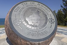
Kudat is the capital of the Kudat District in the Kudat Division of Sabah, Malaysia. Its population was estimated to be around 29,025 in 2010. It is located on the Kudat Peninsula, about 190 kilometres (120 mi) north of Kota Kinabalu, the state capital, and is near the northernmost point of Borneo. It is the largest town in the heartland of the Rungus people which is a sub-ethnic group of the majority Kadazan-Dusun race and is therefore a major centre of Rungus culture. It is also notable for being one of the first parts of Sabah to be settled by Chinese Malaysians, particularly from the Hakka dialect group. It is the Northernmost Malaysian city.
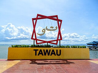
Tawau, formerly known as Tawao, is the capital of the Tawau District in Sabah, Malaysia. It is the third-largest city in Sabah, after Kota Kinabalu and Sandakan. It is located on the Semporna Peninsula in the southeast coast of the state in the administrative centre of Tawau Division, which is bordered by the Sulu Sea to the east, the Celebes Sea to the south at Cowie Bay and shares a border with North Kalimantan, Indonesia. The town had an estimated population as of 2010, of 113,809, while the whole municipality area had a population of 397,673. The municipal area had a population of 372,615 at the 2020 Census.

Kudat Division is an administrative division in the state of Sabah, Malaysia. It occupies the northern tip of Sabah. Its total area of 4,623 square kilometres makes it the smallest of the five divisions of Sabah. The division covers the districts of Kudat, Pitas and Kota Marudu, as well as the islands of Balak, Balambangan, Banggi, Bankawan, Guhuan Utara, Kalampunian and Malawali.
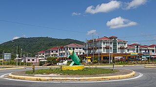
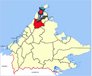
Kota Marudu is the capital of the Kota Marudu District in the Kudat Division of Sabah, Malaysia. Its population was estimated to be around 81,300 in 2019. It is located 130 kilometres north of the state capital, Kota Kinabalu, along the federal highway linking Kota Kinabalu with the town of Kudat, near the northern tip of Borneo.

Sabah State Railway is a railway system and operator in the state of Sabah in Malaysia. It is the only rail transport system operating on the island of Borneo. The railway consists of a single 134-kilometre line from Tanjung Aru, Kota Kinabalu in West Coast Division to the town of Tenom, in the Interior Division. It was formerly known as North Borneo Railway.
Tan Sri Datuk Seri Panglima Chong Kah Kiat is a Malaysian politician who served as Minister in the Prime Minister's Department from May 1995 to March 1999, 13th Chief Minister of Sabah from March 2001 to March 2003 and President of the Liberal Democratic Party (LDP) from 1991 to 2006.
The Diocese of Sabah is an Anglican diocese which covers Sabah and Labuan in Malaysia. Founded in 1962, the see was originally part of the much larger Diocese of Labuan and its Dependencies which was established in 1855. Following the carving out of the Diocese of Singapore in 1909 from this last ecclesiastical territory, the area of the present-day Diocese fell under the jurisdiction of the Diocese of Labuan & Sarawak, which was reorganised as the Diocese of Borneo in 1949. In 1962, the latter diocese was divided into two, forming the Diocese of Kuching and the Diocese of Jesselton, which was renamed the Diocese of Sabah when the capital city was given the new name of Kota Kinabalu in 1967.
The Basel Christian Church of Malaysia or BCCM, formerly known as Borneo Basel Self Established Church, is one of the four Lutheran bodies in Malaysia. In 2009 BCCM had 112 congregations nationwide and 63,000 baptised members. In 2023, BCCM had 64,500 members.
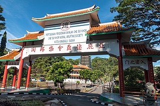
Che Sui Khor Moral Uplifting Society is a Dejiao establishment located in Kota Kinabalu, Sabah, Malaysia. The centre has been opened since 1981.
The Western Sabah Railway Line in Sabah, Malaysia is the name given to rail services that operate from Tanjung Aru until Tenom in the West Coast and Interior divisions under the management of Sabah State Railway. The line previously known as North Borneo Railway Line.

The Kudat District is an administrative district in the Malaysian state of Sabah, part of the Kudat Division which includes the districts of Kota Marudu, Kudat and Pitas. The capital of the district is in Kudat Town.
The Kota Marudu District is an administrative district in the Malaysian state of Sabah, part of the Kudat Division which includes the districts of Kota Marudu, Kudat and Pitas. The capital of the district is in Kota Marudu Town.
The Sandakan Peninsula is a peninsula in Sandakan District, Sabah, Malaysia. It consists of broad coastal and forested areas.
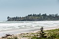
The Kudat Peninsula is a peninsula in northern of Sabah, Malaysia. It consists of high coastal with windy shorelines and swamp areas. The peninsula become the area where the South China Sea meets the Sulu Sea.
The Bengkoka Peninsula is a peninsula in northern of Sabah, Malaysia. It consists of coastal with swampy areas. The peninsula become the area where the South China Sea meets the Sulu Sea.
Sabah Hakka Complex is a five-storey building complex with an event hall located at 26, Signal Hill Road, Tanjung Lipat, Likas of Kota Kinabalu, Sabah, Malaysia. The complex is built as a recognition from the Sabah government to local Hakka Chinese contribution to the economy of Sabah since their early migration with the main building structure is designed after the world-famous traditional Hakka houses in Fujian of China, the Tulao.