
Merdeka Square (Malay : Padang Merdeka) [1] is a square located in Kota Kinabalu, Sabah, Malaysia. The square has a capacity of around 5,000. [2]
Merdeka Square (Malay : Padang Merdeka) [1] is a square located in Kota Kinabalu, Sabah, Malaysia. The square has a capacity of around 5,000. [2]

The square once became the site for sporting events during British North Borneo Crown period. Before the Jesselton Community Hall was built in the 1950s, the square is not just used as a football field, but also became a parade site especially before the construction of Kota Kinabalu Sports Complex. On 16 September 1963, the late Chief Minister Donald Stephens declared the formation of the Federation of Malaysia at the site. Since then, the square is only used for small ceremonies. In 2015, the square was closed for several months for renovation works. [2] On 23 February 2018, it is one of 24 heritage sites in the state that were gazetted by Sabah’s State Heritage Council under new enactment of "State Heritage Enactment 2017". [3] [4]

Sabah is a state of Malaysia located in northern Borneo, in the region of East Malaysia. Sabah has land borders with the Malaysian state of Sarawak to the southwest and Indonesia's North Kalimantan province to the south. The Federal Territory of Labuan is an island just off Sabah's west coast. Sabah shares maritime borders with Vietnam to the west and the Philippines to the north and east. Kota Kinabalu is the state capital and the economic centre of the state, and the seat of the Sabah State government. Other major towns in Sabah include Sandakan and Tawau. The 2020 census recorded a population of 3,418,785 in the state. It has an equatorial climate with tropical rainforests, abundant with animal and plant species. The state has long mountain ranges on the west side which forms part of the Crocker Range National Park. Kinabatangan River, the second longest river in Malaysia runs through Sabah. The highest point of Sabah, Mount Kinabalu is also the highest point of Malaysia.

East Malaysia, or the Borneo States, also known as Malaysian Borneo, is the part of Malaysia on and near the island of Borneo, the world's third-largest island. East Malaysia comprises the states of Sabah, Sarawak, and the Federal Territory of Labuan. The small independent nation of Brunei comprises two enclaves in Sarawak. To the south and southeast is the Indonesian portion of Borneo, Kalimantan. East Malaysia lies to the east of Peninsular Malaysia, the part of the country on the Malay Peninsula. The two are separated by the South China Sea.

Kota Kinabalu, colloquially referred to as KK, is the state capital of Sabah, Malaysia. It is also the capital of the Kota Kinabalu District as well as the West Coast Division of Sabah. The city is located on the northwest coast of Borneo facing the South China Sea. The Tunku Abdul Rahman National Park lies to its west and Mount Kinabalu, which gave the city its name, is located to its east. Kota Kinabalu has a population of 452,058 according to the 2010 census; when the adjacent Penampang and Tuaran districts are included, the metro area has a combined population of 628,725. The 2020 Census revealed an increase in the municipal population to 500,421, while the wider area including the Penampang and Putatan districts had a population of 731,406.
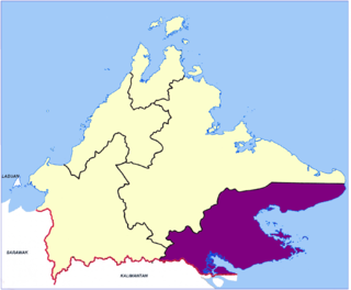
Tawau Division is one of the five administrative sub-divisions of Sabah, Malaysia. It occupies a total of 14,905 square kilometres or 20% of Sabah's territory. The main towns include the capital of Tawau, Lahad Datu, Kunak and Semporna. Tawau division has 26% of Sabah's total population, with the main indigenous groups consisting of the Bajau, Suluk, Ida'an, Tidong, Cocos, Murut, Lun Bawang/Lun Dayeh as well as a minority of mixed ethnic groups. Large numbers of both legal and illegal immigrants from Indonesia such as the Buginese and Torajans, from East Timor the Timorese, from the Philippines the Tausūg and Visayans as well South and West Asian immigrants such as Pakistanis, Indians and Arabs can be found in this area. As with the rest of Sabah, the division also has large numbers of ethnic Chinese.

The Ranau District is an administrative district in the Malaysian state of Sabah, part of the West Coast Division which includes the districts of Kota Belud, Kota Kinabalu, Papar, Penampang, Putatan, Ranau and Tuaran.

Sandakan Division is an administrative division of Sabah, Malaysia. It stretches diagonally from the northeastern coast of Sabah to the state's central region. With an area of 28,205 square kilometres, it occupies 38.3% of Sabah's territory, and is thus the largest of the five administrative divisions of Sabah. It also has approximately 19.4% of Sabah's total population, with the major inhabitants comprising the Chinese, Orang Sungai, Kadazan-Dusun, Suluk and Bajau Simunul.

West Coast Division is an administrative division of Sabah, Malaysia. It occupies the northwest portion of Sabah. With an area of 7,588 square kilometres, it occupies 10.3% of Sabah's territory. It also has approximately 30% of Sabah's total population, with the main indigenous inhabitants comprising the Bajau, Bisaya, Bruneian Malay, Dusun, Illanun, Kadazan and Kedayan, as well with a significant numbers of Chinese. The division is divided into the districts of Ranau, Kota Belud, Tuaran, Penampang, Papar, and the state capital Kota Kinabalu. The main towns are as in the names of the districts, plus other towns including Putatan, Inanam, Telipok, Tamparuli, Tenghilan and Kinarut.

Sabah State Railway is a railway system and operator in the state of Sabah in Malaysia. It is the only rail transport system operating on the island of Borneo. The railway consists of a single 134-kilometre line from Tanjung Aru, Kota Kinabalu in West Coast Division to the town of Tenom, in the Interior Division. It was formerly known as North Borneo Railway.

The Kota Kinabalu City Hall is the city council which administers the city and district of Kota Kinabalu in the state of Sabah, Malaysia. The council consists of the mayor plus twenty-four councillors appointed to serve a one-year term by the Sabah State Government.

Lok Kawi is a township in the West Coast Division of Sabah, Malaysia. Located around the border of the districts of Penampang and Papar, and about 15 kilometres south of the state capital Kota Kinabalu, it has become part of the urban expanse of Kota Kinabalu. Nearby towns include Putatan in the north, and Kinarut in the south.

Muhammad Fuad Stephens, was a Malaysian politician who served as the 1st and 5th Chief Minister of Sabah from September 1963 to December 1964 and again briefly from April 1976 to his death in June 1976, 3rd Yang di-Pertua Negara of Sabah from September 1973 to July 1975, 6th High Commissioner of Malaysia to Australia from 1968 to 1973. In addition, he also served as the 1st Huguan Siou or Paramount Leader of the Kadazandusun community. He played a role in bringing Sabah into the Federation of Malaysia in 1963. While he was initially against the idea of Sabah joining in the Federation, given British concerns about the stability of the region and their move to relinquish all their colonies in the post WWII era, he was gradually convinced to work towards it. He held the chief minister's post from 16 September 1963 until 31 December 1964 when he was forced to resign; and again in 1976 for 54 days from 15 April.

Sekolah Menengah Sains Sabah is a fully residential school established in Malaysian state of Sabah. As the first fully residential school in East Malaysia and the 27th of its kind in Malaysia, SMESH was previously known as Sekolah Berasrama Penuh Sabah (SBPS). SMESH was established in 1978 but became fully operational on 1 January 1984. It has a 16-acre (65,000 m2) permanent campus in Bukit Padang, Kota Kinabalu. Due to the unsafe state of the campus, SMESH is temporarily operated in a temporary campus in Tuaran.

Greater Kota Kinabalu refers to the dense clusters of regional populated areas surrounding the city of Kota Kinabalu in Malaysia. It comprises the districts of Kota Kinabalu, Penampang, Tuaran and Papar. These districts are also part of the West Coast Division. It was forecasted that in 2019, the combined population of these districts was 1.1 million people, in a combined area of 3,277 km2.

The Atkinson Clock Tower is the oldest standing structure in Kota Kinabalu. It was originally known as the Atkinson Memorial Clock Tower and sits in solitary on the bluff along Signal Hill Road overlooking this seaside city and capital of Sabah, Malaysia.

Sabah Day is a self-government day celebrated on 31 August every year by the state of Sabah in Malaysia. Since 2012, the holiday has been received widely by the Sabah state government and the citizens of Sabah, as the Independence Day of Malaya was not the right celebration day for the state.
Imago KK Times Square Shopping Mall is a shopping mall located at the city center of Kota Kinabalu, Sabah, Malaysia. It was developed and managed by Syarikat Kapasi Sdn. Bhd., which is a wholly owned subsidiary of Asian Pac Holdings Berhad, a company listed on the Main Board of the Kuala Lumpur Stock Exchange. Imago was opened on 28 March 2015.

The Sabah Tourism Board, or generally known as Sabah Tourism, is an agency of the Sabah State Government operating under the purview of the Ministry of Tourism, Culture and Environment. Sabah Tourism’s primary responsibility is the marketing and promotion of tourism for the State.
Tun Fuad Stephens Park is a recreational park in Bukit Padang, Kota Kinabalu, Sabah, Malaysia. It is built in honour of the late Chief Minister of Sabah Fuad Stephens who perished in the Double Six Tragedy in 1976.

The Penampang District is an administrative district in the Malaysian state of Sabah, part of the West Coast Division which includes the districts of Kota Belud, Kota Kinabalu, Papar, Penampang, Putatan, Ranau and Tuaran. The capital of the district is in Penampang Town.

Nabalu or better known as Pekan Nabalu is a small town that is the main focus of visitors to see Mount Kinabalu in its entirety. The variety of restaurants and the fresh weather, also the view that shows Mount Kinabalu as a whole are the main reasons why many tourists come to visit Pekan Nabalu. This town is close to SK. Dalas, Kota Belud and became the main education center for the residents of Pekan Nabalu.
5°58′50.9916″N116°4′37.0524″E / 5.980831000°N 116.076959000°E