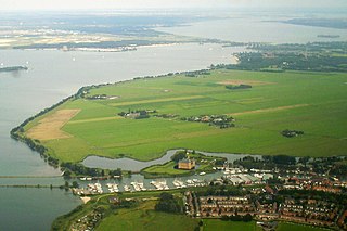
Muiden is a city and former municipality in the Netherlands, in the province of North Holland. It lies at the mouth of the Vecht and is in an area called the Vechtstreek. Since 2016, Muiden has been part of the new municipality of Gooise Meren.

El Jadida is a major port city on the Atlantic coast of Morocco, located 96 kilometres (60 mi) south of the city of Casablanca, in the province of El Jadida and the region of Casablanca-Settat. It has a population of 170,956 as of 2023.

Malacca City is the capital city of the Malaysian state of Malacca, in Melaka Tengah District. It is the oldest Malaysian city on the Straits of Malacca, having become a successful entrepôt in the era of the Malacca Sultanate. The present-day city was founded by Parameswara, a Sumatran prince who escaped to the Malay Peninsula when Srivijaya fell to the Majapahit. Following the establishment of the Malacca Sultanate, the city drew the attention of traders from the Middle East, South Asia, and East Asia, as well as the Portuguese, who intended to dominate the trade route in Asia. After Malacca was conquered by Portugal, the city became an area of conflict when the sultanates of Aceh and Johor attempted to take control from the Portuguese.

Fort Marlborough is a former East India Company fort located in Bengkulu City, Sumatra. It was built between 1713 and 1719 by the East India Company under the leadership of Governor Joseph Collett as a defensive fort for the British East India Company's Residency there. It was one of the strongest British forts in the eastern region, second only to Fort St. George in Madras, India.

Fort Manoel is a star fort on Manoel Island in Gżira, Malta. It was built in the 18th century by the Order of Saint John, during the reign of Grand Master António Manoel de Vilhena, after whom it is named. Fort Manoel is located to the north west of Valletta, and commands Marsamxett Harbour and the anchorage of Sliema Creek. The fort is an example of Baroque architecture, and was designed with both functionality and aesthetics in mind.
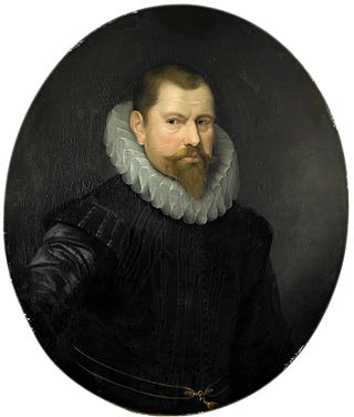
Cornelis Matelief de Jonge was a Dutch admiral who was active in establishing Dutch power in Southeast Asia during the beginning of the 17th century. His fleet was officially on a trading mission, but its true intent was to destroy Portuguese power in the area. The fleet had 1400 men on board, including 600 soldiers. Matelieff did not succeed in this. The Dutch would ultimately gain control of Malacca more than thirty years later, again joining forces with the Sultanate of Johor, and a new ally Aceh, in 1641. He was born and died in Rotterdam.

A Famosa was a Portuguese fortress built in Malacca, Malaysia, circa 1512. The oldest part of the fortress was a five-storey keep which eventually gave its name to the fortress as a whole. Some time following the Battle of Malacca (1641) and the occupation of the city by the Dutch, the keep was destroyed but the outer walls of the fortress were expanded. However, in 1811 the British destroyed all of the original fortress and most of the outer walls. The Porta de Santiago gateway, and the rebuilt Middelburg Bastion, are the only parts of the fortress that remain today.

The Malacca River is a river in Malaysia which flows through the middle of the state of Malacca. It was a vital trade route during the heyday of Malacca Sultanate in the 15th century.

The Battle of Cape Rachado, off Cape Rachado in 1606, was an important naval engagement between the Dutch East India Company (VOC) and Portuguese Navy.

Dutch Malacca (1641–1825) was the longest period that Malacca was under foreign control. The Dutch ruled for almost 183 years with intermittent British occupation during the French Revolutionary and later the Napoleonic Wars (1795–1815). This era saw relative peace with little serious interruption from the Malay sultanates due to the understanding forged between the Dutch and the Sultanate of Johor in 1606. This period also marked the decline of Malacca's importance. The Dutch preferred Batavia as their economic and administrative centre in the region and their hold in Malacca was to prevent the loss of the city to other European powers and, subsequently, the competition that would come with it. Thus, in the 17th century, with Malacca ceasing to be an important port, the Johor Sultanate became the dominant local power in the region due to the opening of its ports and the alliance with the Dutch.

Portuguese control of Malacca –a city on the Malay Peninsula– spanned a 130 year period from 1511 to 1641 as a possession of the Portuguese East Indies. It was captured from the Malacca Sultanate as part of Portuguese attempts to gain control of trade in the region. Although multiple attempts to conquer it were repulsed, the city was eventually lost to an alliance of Dutch and regional forces, thus beginning a period of Dutch rule.

Malacca, officially the Historic State of Malacca, is a state in Malaysia located in the southern region of the Malay Peninsula, facing the Strait of Malacca. The state is bordered by Negeri Sembilan to the north and west and Johor to the south. The exclave of Tanjung Tuan also borders Negeri Sembilan to the north. Its capital is Malacca City, which has been listed as a UNESCO World Heritage Site since 7 July 2008.

The Siege of the Portuguese fort Santa Cruz de Gale at Galle in 1640, took place during the Dutch–Portuguese and Sinhalese–Portuguese Wars. The Galle fort commanded 282 villages, which contained most fertile cinnamon lands in southern Sri Lanka It was also an important strategic coastal defense of Portuguese Ceylon. The Dutch, who were in an alliance with the Kingdom of Kandy, landed an expeditionary force under Commodore Willem Jacobszoon Coster of Akersloot, at the Bay of Galle, on 8 March 1640. After bombarding the fort for four consecutive days, Dutch troops stormed the fort and secured a victory on 13 March 1640. The Portuguese garrison, led by Captain Lourenço Ferreira de Brito, mounted a stiff resistance and unexpectedly high casualty rates among Dutch troops gave rise to the proverb “Gold in Malacca, lead in Galle”. With this victory the Dutch gained access to a large port which they later used as a convenient naval base to attack Goa and other South Indian Portuguese defenses. They also gained access to the Sri Lankan cinnamon trade and gained a permanent foothold on the island.

The Malaysia Youth Museum is a museum in Malacca City, Malacca, Malaysia, which dedicated to the youth of Malaysia and their contribution to the economic and social wellbeing at regional, national, and international levels.

St. Paul's Hill is a hill in Malacca City, Malacca, Malaysia. It was originally known as Malacca Hill during the Sultanate period and Mary's Hill during the Portuguese period.
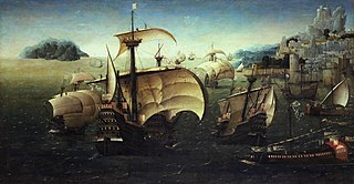
The War of the League of the Indies was a military conflict lasting from December 1570 to 1575, wherein a pan-Asian alliance attempted to overturn the Portuguese presence in the Indian Ocean. The pan-Asian alliance was formed primarily by the Sultanate of Bijapur, the Sultanate of Ahmadnagar, the Kingdom of Calicut, and the Sultanate of Aceh. It is referred to by the Portuguese historian António Pinto Pereira as "the League of Kings of India", "the Confederated Kings", or simply "the League". The alliance undertook a combined assault against some of the primary possessions of the Portuguese State of India: Malacca, Chaul, the Chale fort, and the capital of the maritime empire in Asia, Goa.

The Fort of São Julião da Barra is the largest and most complete military defence complex in the Vauban style remaining in Portugal. It is located in São Julião da Barra, on the point of São Gião, in the parish of Oeiras e São Julião da Barra, Paço de Arcos e Caxias, Oeiras Municipality, Lisbon District. Considered in the past as the most important maritime fortification in the country, it had originally, together with the Fort of São Lourenço do Bugio, the role of controlling access to the port of Lisbon. It is currently the official residence of the Portuguese Minister of National Defence.
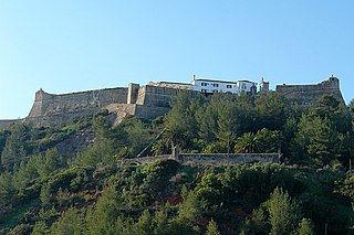
The Fort of São Filipe de Setúbal, also referred to as the São Filipe Castle or the São Filipe Fortress, is in the city of Setúbal in the Setúbal District, of Portugal. The fort was built on the orders of Philip II of Spain, who personally witnessed the laying of the cornerstone of the new fortification in 1582. It stands in a dominant position on the right bank of the mouth of the Sado River, overlooking the centre of Setúbal to its east and guarding access to the river. Named after the king during the Iberian Union, the fortress was designed by Giovan Giacomo Paleari Fratino and had the Italian military engineer Filipe Terzi, who worked for the Spanish Royal Court, as its chief engineer. It was completed in 1600 under the guidance of Leonardo Torreano due to the death of Terzi.

The Fort of Ponta da Bandeira, also known as Pau da Bandeira Fort ; Fort of Nossa Senhora da Penha de França ; the Fort of Registo ; or the Fort of Lagos is situated in the city of Lagos, in the Faro District of Portugal. It was built in the 17th century, as one of the main components of a system of maritime fortifications to defend the city, then headquarters of the military government of the Algarve. Significant restoration work has been carried out over the years and the fort is considered to be one of the best-preserved 17th century fortifications in the Algarve region.


