Related Research Articles

Sabah is a state of Malaysia located on the northern portion of Borneo, in the region of East Malaysia. Sabah has land borders with the Malaysian state of Sarawak to the southwest and Indonesia's North Kalimantan province to the south. The Federal Territory of Labuan is an island just off Sabah's west coast. Sabah shares maritime borders with Vietnam to the west and the Philippines to the north and east. Kota Kinabalu is the state capital and the economic centre of the state, and the seat of the Sabah State government. Other major towns in Sabah include Sandakan and Tawau. The 2020 census recorded a population of 3,418,785 in the state. It has an equatorial climate with tropical rainforests, abundant with animal and plant species. The state has long mountain ranges on the west side which forms part of the Crocker Range National Park. Kinabatangan River, the second longest river in Malaysia runs through Sabah. The highest point of Sabah, Mount Kinabalu is also the highest point of Malaysia.

East Malaysia, or the Borneo States, also known as Malaysian Borneo, is the part of Malaysia on and near the island of Borneo, the world's third-largest island. East Malaysia comprises the states of Sabah, Sarawak, and the Federal Territory of Labuan. The small independent nation of Brunei lies sandwiched between Sabah and Sarawak. To the south and southeast is the Indonesian portion of Borneo, Kalimantan. East Malaysia lies to the east of Peninsular Malaysia, the part of the country on the Malay Peninsula. The two are separated by the South China Sea.

Kuching, officially the City of Kuching, is the capital and the most populous city in the state of Sarawak in Malaysia. It is also the capital of Kuching Division. The city is on the Sarawak River at the southwest tip of the state of Sarawak on the island of Borneo and covers an area of 431 km2 (166 sq mi) with a population about 165,642 in the Kuching North administrative region and 159,490 in the Kuching South administrative region—a total of 325,132 people.

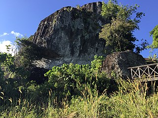
A petroglyph is an image created by removing part of a rock surface by incising, picking, carving, or abrading, as a form of rock art. Outside North America, scholars often use terms such as "carving", "engraving", or other descriptions of the technique to refer to such images. Petroglyphs, estimated to be 20,000 years old are classified as protected monuments and have been added to the tentative list of UNESCO's World Heritage Sites. Petroglyphs are found worldwide, and are often associated with prehistoric peoples. The word comes from the Greek prefix petro-, from πέτρα petra meaning "stone", and γλύφω glýphō meaning "carve", and was originally coined in French as pétroglyphe.
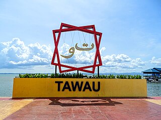
Tawau, formerly known as Tawao, is the capital of the Tawau District in Sabah, Malaysia. It is the third-largest city in Sabah, after Kota Kinabalu and Sandakan. It is located on the Semporna Peninsula in the southeast coast of the state in the administrative centre of Tawau Division, which is bordered by the Sulu Sea to the east, the Celebes Sea to the south at Cowie Bay and shares a border with North Kalimantan, Indonesia. The town had an estimated population as of 2010, of 113,809, while the whole municipality area had a population of 397,673. The municipal area had a population of 372,615 at the 2020 Census.
Malaysia is a country in Southeast Asia. The federal constitutional monarchy consists of thirteen states and three federal territories, separated by the South China Sea into two regions: Peninsular Malaysia and Borneo's East Malaysia. Peninsular Malaysia shares a land and maritime border with Thailand and maritime borders with Singapore, Vietnam, and Indonesia. East Malaysia shares land and maritime borders with Brunei and Indonesia, as well as a maritime border with the Philippines and Vietnam. Kuala Lumpur is the national capital, the country's largest city, and the seat of the legislative branch of the federal government. Putrajaya is the country's administrative centre, which represents the seat of both the executive branch and the judicial branch of the federal government. With a population of over 33 million, Malaysia is the world's 43rd-most populous country. The southernmost point of continental Eurasia is Tanjung Piai. Located in the tropics, Malaysia is one of 17 megadiverse countries and home to numerous endemic species.

Crocker Mountains is a mountain range extending from the West Coast until Interior divisions of Sabah, Malaysia that separates the west and east coast of Sabah. At an average height of 1,800 metres (5,906 ft), it is the highest mountain range in the state named after the British administrator in North Borneo, William Maunder Crocker.
The Austronesian peoples, sometimes referred to as Austronesian-speaking peoples, are a large group of peoples in Taiwan, Malay Peninsula, parts of Mainland Southeast Asia, Maritime Southeast Asia, Micronesia, coastal New Guinea, Island Melanesia, Polynesia, and Madagascar that speak Austronesian languages. They also include indigenous ethnic minorities in Vietnam, Cambodia, Myanmar, Thailand, Hainan, the Comoros, and the Torres Strait Islands. The nations and territories predominantly populated by Austronesian-speaking peoples are sometimes known collectively as Austronesia.

The Mah Meri are an ethnic group native to western part of Peninsular Malaysia. They are one of the 18 Orang Asli groups named by the Malaysian government. They are of the Senoi subgroup. Most of the members of the Mah Meri tribe live along the coast of South Selangor from Sungai Pelek up to Pulau Carey, although there is at least one Mah Meri Community on the other side of the Klang River.

Architecture in Malaysia traditionally consist of malay vernacular architecture. Though modern contemporary architecture is prevalent in urban areas there are style influences from Islamic, colonial architecture, chinese straits etc. New materials, such as glasses and nails, were brought in by Europeans, changing the architecture.

Datu Mustapha bin Datu Harun, or Tun Mustapha for short, was a Malaysian politician who served as the 3rd Chief Minister of Sabah from May 1967 to November 1975 and the 1st Yang Di-Pertua Negara from September 1963 to September 1965 and President of the United Sabah National Organisation (USNO). He is considered by some to be one of the founding leaders of Sabah and was an important party in the negotiations leading to the formation of Malaysia on 16 September 1963. He is sometimes known as the "Father of Independence of Sabah" and also the "Father of Development of Sabah".

The Sugar Grove Petroglyphs are a group of petroglyphs in the southwestern part of the U.S. state of Pennsylvania. Located on an outcrop of sandstone in Monongahela Township near the eastern edge of Greene County, the petroglyphs have been known since at least the 1930s. Due to their value as an archaeological site, the petroglyphs have been named a historic site.

Agop Batu Tulug Caves is an archaeological site in the Malaysian state of Sabah and refers to a group of several caves in a steep limestone cliffs in the Kinabatangan district.

Archaeology of Qatar as a field study began in 1956. Three major expeditions were carried out in Qatar throughout the mid-20th century, with the first being launched by a Danish team who began work in the 1950s. This was followed by British and French expeditions in 1970s and 1980s, respectively. Approximately 200 archaeological sites were discovered during these expeditions, with the most extensive being the coastal areas of Al Da'asa, Ras Abrouq and Al Khor Island. Artifacts such as flint tools, Ubaid and Barbar pottery and encampments were found in situ.
Sarawak exhibits notable diversity in ethnicity, culture, and language. The Sarawakian culture has been influenced by Bruneian Malays of the coastal areas. Substantial cultural influences also came from the Chinese and British cultures.

Sabah is the third most populous state in Malaysia, with a population of 3,418,785 according to the 2020 Malaysian census. It also has the highest non-citizen population, at 810,443. Although Malaysia is one of the least densely populated countries in Asia, Sabah is particularly sparsely populated. Most of the population is concentrated along coastal areas, with towns and urban centers seeing the most population growth.
The Kudat Peninsula is a peninsula in northern of Sabah, Malaysia. It consists of high coastal with windy shorelines and swamp areas. The peninsula become the area where the South China Sea meets the Sulu Sea.
Skull Hill is an archaeological site hill located at Tampi Tampi Road, about 10 kilometres (6.2 mi) south of Semporna town.

The Papar River is a river in West Coast Division, northwestern Sabah of Malaysia. It has a total length of 60 km (37 mi) from its headwaters in the mountains of northwest Sabah to its outlet at the South China Sea, northwest of Papar town. Its source is originated from the mountains in the interior Papar, Penampang and Tuaran Districts, which part of the Crocker Range system. These includes the area of Babagon, Bonobukan, Buayan, Central Papar, Gramatoi, Himpangno, Kaiduan, Kalangan, Kawari, Kogopon, Lingan, Mandalipau, Marahang, Padawan, Terian, Tiku and Ulu Papar.

Traditional Malaysian art is primarily composed of Malay art and Bornean art, is very similar with the other styles from Southeast Asia, such as Bruneian, Indonesian and Singaporean. Art has a long tradition in Malaysia, with Malay art that dating back to the Malay sultanates, has always been influenced by Chinese, Indian and Islamic arts, and also present, due to large population of Chinese and Indian in today's Malaysian demographics.
References
- 1 2 3 "Lumuyu Rock Carving". Sabah Museum. Archived from the original on 28 June 2019. Retrieved 28 June 2019.
- ↑ "Beauty of Sabah in rural setting". The Borneo Post. 1 March 2015. Retrieved 28 June 2019– via PressReader.
- 1 2 3 M. Malik Awang Rasin (31 July 2015). "A Decade of Archaeological Research and UMS Cultural Heritage (2003-2013)". Universiti Malaysia Sabah. Archived from the original on 28 June 2019. Retrieved 28 June 2019.
- ↑ Farouk Yahya (21 October 2015). Magic and Divination in Malay Illustrated Manuscripts. BRILL. p. 12. ISBN 978-90-04-30172-6.
- ↑ APA Publications Limited (1 April 2019). Insight Guides Malaysia (Travel Guide eBook). Apa Publications (UK) Limited. p. 766. ISBN 978-1-78919-399-2.
- ↑ Peter G. Gould; K. Anne Pyburn (26 November 2016). Collision or Collaboration: Archaeology Encounters Economic Development. Springer. p. 40. ISBN 978-3-319-44515-1.
- ↑ Mohd Nor Amiruddin Nora Afandi; Baszley Bee Basrah Bee (2016). "Petroglif Lumuyu: Suatu Pendokumentasian Semula" [Lumuyu Petroglyph: A Redocumentation]. Malaysia Journal of Archaeology, Universiti Kebangsaan Malaysia (in Malay). 29 (1). Retrieved 28 June 2019.