Brunei, officially Brunei Darussalam, is a country in Southeast Asia, situated on the northern coast of the island of Borneo. Apart from its coastline on the South China Sea, it is completely surrounded by the Malaysian state of Sarawak, with its territory bifurcated by the Sarawak district of Limbang. Brunei is the only sovereign state entirely on Borneo; the remainder of the island is divided between its multi-landmass neighbours of Malaysia and Indonesia. As of 2023, the country had a population of 455,858, of whom approximately 180,000 resided in the capital and largest city of Bandar Seri Begawan. Its official language is Malay and Islam is the state religion of the country, although other religions are nominally tolerated. The government of Brunei is a constitutional absolute monarchy ruled by the Sultan, and it implements a fusion of English common law and jurisprudence inspired by Islam, including sharia.

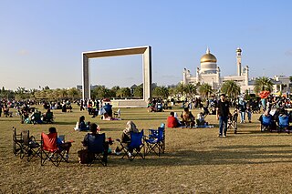
Bandar Seri Begawan (BSB) is the capital and largest city of Brunei. It is officially a municipal area with an area of 100.36 square kilometres (38.75 sq mi) and an estimated population of 100,700 as of 2007. It is part of Brunei–Muara District, the smallest yet most populous district which is home to over 70 per cent of the country's population. It is the country's largest urban centre and nominally the country's only city. The capital is home to Brunei's seat of government, as well as a commercial and cultural centre. It was formerly known as Brunei Town until it was renamed in 1970 in honour of Omar Ali Saifuddien III, the 28th Sultan of Brunei and the father of Sultan Hassanal Bolkiah.
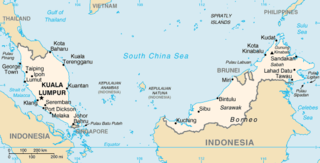
The geography of Malaysia includes both the physical and the human geography of Malaysia, a Southeast Asian country made up of two major landmasses separated by water—Peninsular Malaysia to the west and East Malaysia to the east—and numerous smaller islands that surround those landmasses. Peninsular Malaysia is on the southernmost part of the Malay Peninsula, south of Thailand, north of Singapore and east of the Indonesian island of Sumatra; East Malaysia comprises most of the northern part of Borneo, and shares land borders with Brunei to the north and Indonesian Borneo to the south.

Belait District or simply known as Belait, is the largest as well as the westernmost district in Brunei. It has an area of 2,727 square kilometres (1,053 sq mi) and the population of 65,531 as of 2021. The administrative town is Kuala Belait, located at the mouth of the 32 kilometres (20 mi) long Belait River. The district is commonly associated with the oil and gas industry of the country, mainly concentrated near the town of Seria.
Brunei–Muara District or simply known as Brunei–Muara, is the smallest as well as the most populated district in Brunei. It has an area of 571 square kilometres (220 sq mi) and the population of 318,530 as of 2021. The district is also home to its administrative centre is Bandar Seri Begawan, as well as the Brunei International Airport and Muara Port, the country's only international airport and deep-water port respectively. The Brunei River flows within this district and is home to Kampong Ayer. As the administrative center of Brunei is located in the district, it remains the most developed in the country with the most up-to-date infrastructure, despite not being the center of Brunei's main economic activity.

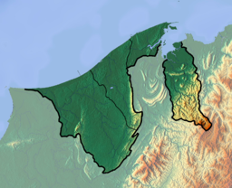
Temburong District or simply known as Temburong, is the second largest and least populated district in Brunei. It has an area of 1,306 square kilometres (504 sq mi) and the population of 9,444 as of 2021. The district is also home to its administrative centre, Bangar Town, as well as the Temburong River and Ulu Temburong National Park, the country's third longest river and a national park in Brunei respectively.
Bangar or officially known as Bandar Town, is a town and administrative centre of Temburong District, Brunei, an isolated territorial exclave separated from the rest of the country by the Malaysian state of Sarawak. The population of the town proper was 451 in 2021. A number of tiny retail establishments may be found throughout the town, providing everything from clothing to handicrafts to basic needs.
Mukim Bangar is a mukim in Temburong District, Brunei. It has a total area of 113 square kilometres (44 sq mi); the population was 2,112 in 2021. The mukim encompasses Bangar, the district's sole town and administrative centre.

Mukim Bokok is a mukim in Temburong District, Brunei. It has an area of 136 square kilometres (53 sq mi); as of 2021, the population was 3,812.

Mukim Labu is a mukim in Temburong District, Brunei. It has an area of 292 square kilometres (113 sq mi); the population was 508 in 2021.

The Brunei–Malaysia border divides the territories of Brunei and Malaysia on the island of Borneo. It consists of a 528.45 km (328.36 mi) land border and substantial lengths of maritime borders stretching from the coastline of the two countries to the edge of the continental shelf in the South China Sea.
Kiang West National Park is one of the largest and most important wildlife reserves in the Gambia. It was declared a national park in 1987 and is managed by the Gambia Department of Parks and Wildlife Management.

The Pandaruan River is a river that forms an international border on the island of Borneo, between Temburong, Brunei and Limbang, Malaysia. It is located at the river mouth of the Brunei Bay.

Ulu Temburong National Park is the first national park to be established in Brunei, protected since 1991. The park is in Temburong District in eastern Brunei, and covers about 40% of the district in the south at 550 square kilometres (210 sq mi). It is within the Batu Apoi Forest Reserve. The park contains unspoiled jungle and is known as the "Green Jewel of Brunei", described as "the finest example of the sultanate's successful forest protection policy". The principal rivers are the Temburong and Belalong Rivers. It is an important ecotourism centre in Brunei and hosts the Ulu Ulu Resort. The Peradayan Forest Reserve is also located in the district.

Sultan Haji Omar 'Ali Saifuddien Bridge, also known as Temburong Bridge, is a dual-carriageway bridge in Brunei that spans across Brunei Bay, connecting the Bruneian mainland with its semi-exclave of Temburong. It is the longest bridge in Southeast Asia, at 30 kilometres (19 mi) long.

Transport in Brunei consists of air, land, and sea transport. Previously there was some rail transport in Brunei, but eventually most of it was closed down. Several public and commercial sector organizations are in charge of creating and overseeing these networks and infrastructures. The Ministry of Transport and Infocommunications (MTIC) is in charge of overseeing the maritime and aviation industries, as well as planning and regulating all kinds of land transportation.
Kampong Bokok or simply Bokok, is a village in Temburong District, Brunei, about 10 kilometres (6.2 mi) from the district town Bangar. The population was 160 in 2021. It is one of the villages within Mukim Bokok. The postcode is PE1951.

Selirong Island, also known as Mosquito Island, is an island located within the Brunei Bay and Mukim Labu, Temburong District, Brunei. The island also sits at the river delta of the Temburong River.

Berambang Island is an island at the southern bank of the Brunei River in the Mukim Kota Batu, Brunei-Muara District, Brunei. The island was formerly named Buang Tawer during The Brooke Era from 1841 until 1941. The mausoleum of the 9th Sultan of Brunei, Sultan Muhammad Hassan is located on the island, near Kampong Sungai Bunga.
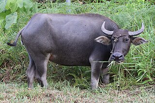
The flora and fauna of Brunei Darussalam is one of its primary draws. Tropical evergreen rainforest makes up the majority of the country's natural vegetation. 81% of the land is covered by forests, with 59% being primary forests and 22% being secondary forests and plantations. With an estimated 2,000 species of trees, Brunei is home to an estimated 15,000 different species of Vascular plants. Brunei's mammal and bird populations are comparable to those of Sumatra, the Malaysian Peninsula, and Borneo as a whole.