Terusan

Last updated
Terusan

Trusan
village
Malaysia location map.svg
Red pog.svg
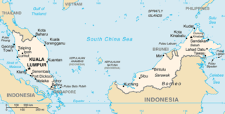
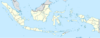
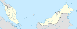
Terusan
Location in Sabah, Malaysia
Coordinates: 6°26′0″N117°41′0″E / 6.43333°N 117.68333°E / 6.43333; 117.68333 Coordinates: 6°26′0″N117°41′0″E / 6.43333°N 117.68333°E / 6.43333; 117.68333
Country Malaysia
State Sabah
Elevation
0 m (3 ft)
Time zone UTC+8 (MST)

Terusan (also known as Trusan) is a settlement in Sabah, Malaysia. It is about three feet above sea level, and the approximate population within a seven-kilometer radius was 818 as of 2004. [1]

Sabah State of Malaysia

Sabah is a state of Malaysia located on the northern portion of Borneo Island. Sabah has land borders with the Malaysian state of Sarawak to the southwest, and Indonesia's Kalimantan region to the south. The Federal Territory of Labuan is an island just off the Sabah coast. Sabah shares maritime borders with Vietnam in the west and the Philippines to the north and east. Kota Kinabalu is the state capital city, the economic centre of the state and the seat of the Sabah state government. Other major towns in Sabah include Sandakan and Tawau. As of the 2015 census in Malaysia, the state's population is 3,543,500. Sabah has an equatorial climate with tropical rainforests and abundant animal and plant species. The state has long mountain ranges on the west side which form part of the Crocker Range National Park. Kinabatangan River, second longest river in Malaysia runs through Sabah and Mount Kinabalu is the highest point of Sabah as well as of Malaysia.

Malaysia Federal constitutional monarchy in Southeast Asia

Malaysia is a country in Southeast Asia. The federal constitutional monarchy consists of 13 states and three federal territories, separated by the South China Sea into two similarly sized regions, Peninsular Malaysia and East Malaysia. Peninsular Malaysia shares a land and maritime border with Thailand in the north and maritime borders with Singapore in the south, Vietnam in the northeast, and Indonesia in the west. East Malaysia shares land and maritime borders with Brunei and Indonesia and a maritime border with the Philippines and Vietnam. Kuala Lumpur is the national capital and largest city while Putrajaya is the seat of federal government. With a population of over 30 million, Malaysia is the world's 44th most populous country. The southernmost point of continental Eurasia, Tanjung Piai, is in Malaysia. In the tropics, Malaysia is one of 17 megadiverse countries, with large numbers of endemic species.

Sea level Average level for the surface of the ocean at any given geographical position on the planetary surface

Mean sea level (MSL) is an average level of the surface of one or more of Earth's oceans from which heights such as elevation may be measured. MSL is a type of vertical datum – a standardised geodetic datum – that is used, for example, as a chart datum in cartography and marine navigation, or, in aviation, as the standard sea level at which atmospheric pressure is measured to calibrate altitude and, consequently, aircraft flight levels. A common and relatively straightforward mean sea-level standard is the midpoint between a mean low and mean high tide at a particular location.

Nearby towns and villages include Jambongan (17.6 nm north), Tagahan (6.3 nm south), Boaan (24.6 nm east), Si Kub (56.8 nm east), and Suba Talan (2.2 nm west). [1]

Nautical mile unit of distance (1852 m)

A nautical mile is a unit of measurement used in both air and marine navigation, and for the definition of territorial waters. Historically, it was defined as one minute of a degree of latitude. Today it is defined as exactly 1852 metres. The derived unit of speed is the knot, one nautical mile per hour.

Related Research Articles

Geography of Malaysia

The geography of Malaysia deals with the physical and human geography of Malaysia, a Southeast Asian country. There are two major parts to this country, Peninsular Malaysia to the west and East Malaysia to the east. In additional, there are numerous smaller islands surrounding both landmasses. Peninsular Malaysia is situated on the southernmost section of the Malay Peninsula, south of Thailand, north of Singapore and east of the Indonesian island of Sumatra; East Malaysia comprises most of the northern part of Borneo island, with land borders shared with Brunei to the north and Indonesian Borneo which is to the south.

Sungai Tujoh Place in Brunei, Brunei

Sungai Tujoh, also abbreviated as Sg. Tujoh, is the westernmost point of Brunei. It is located in the Belait district. The name of the area is derived from two Bruneian Malay words - Sungai, which means river or stream, and Tujoh or the number seven. Literally, Sungai Tujoh is translated as the Seventh River or Seventh Stream in English.

Ampelu Place in Jambi Province, Indonesia

Ampelu is a village in the Batang Hari Regency in the Jambi Province of Sumatra, Indonesia.

Jebak Place in Jambi Province, Indonesia

Jebak is a village in the Batang Hari Regency in the Jambi Province of Sumatra, Indonesia.

Muarabulian Place in Jambi Province, Indonesia

Muarabulian is the capital of Batang Hari Regency in the Jambi Province of Sumatra, Indonesia.

Punang Terusan town in Sarawak, Malaysia

Punang Terusan is a town or settlement in Sarawak, Malaysia. It is about 3,628 feet (1,105 meters) above sea level, and the approximate population within a seven-kilometer radius was 1,110 as of 2004.

Long Semado Place in Sarawak, Malaysia

Long Semado is a settlement in the Lawas division of Sarawak, Malaysia. It lies approximately 654.6 kilometres (407 mi) east-north-east of the state capital Kuching.

Long Merarap Place in Sarawak, Malaysia

Long Merarap is a settlement in the Lawas division of Sarawak, Malaysia. It lies approximately 648.3 kilometres (403 mi) east-north-east of the state capital Kuching.

Long Lapukan Place in Sarawak, Malaysia

Long Lapukan is a settlement in the Lawas division of Sarawak, Malaysia. It lies approximately 650.5 kilometres (404 mi) east-north-east of the state capital Kuching.

Long Karabangan Place in Sarawak, Malaysia

Long Karabangan is a settlement in the Lawas division of Sarawak, Malaysia. It lies approximately 648.8 kilometres (403 mi) east-north-east of the state capital Kuching.

Long Lopeng Place in Sarawak, Malaysia

Long Lopeng is a settlement in the Lawas division of Sarawak, Malaysia. It lies approximately 646.4 kilometres (402 mi) east-north-east of the state capital Kuching.

Long Kinoman Place in Sarawak, Malaysia

Long Kinoman is a settlement in the Lawas division of Sarawak, Malaysia. It lies approximately 658.7 kilometres (409 mi) east-north-east of the state capital Kuching.

Long Tanid Place in Sarawak, Malaysia

Long Tanid is a settlement in the Lawas division of Sarawak, Malaysia. It is about 3 hours drive from Lawas just before entering Ba'kelalan.

Pa Brayong Place in Sarawak, Malaysia

Pa Brayong is a settlement in the Lawas division of Sarawak, Malaysia. It lies approximately 658.5 kilometres (409 mi) east-north-east of the state capital Kuching.

Semporna is a federal constituency in Sabah, Malaysia, that has been represented in the Dewan Rakyat since 1986.

Tanjong Karang is a federal constituency in Selangor, Malaysia, that has been represented in the Dewan Rakyat since 1974.

Kuala Pilah is a federal constituency in Negeri Sembilan, Malaysia, that has been represented in the Dewan Rakyat since 1959.

Kubang Kerian is a federal constituency in Kelantan, Malaysia, that has been represented in the Dewan Rakyat since 1995.

Beluran is a federal constituency in Sabah, Malaysia, that has been represented in the Dewan Rakyat since 1995.

Juasseh is a state constituency in Negeri Sembilan, Malaysia, that has been represented in the Negeri Sembilan State Legislative Assembly.

References

  1. 1 2 “Terusan, Malaysia”. Falling Rain Genomics. 2004.