Sebatik Island is an island off the eastern coast of Borneo, split between Indonesia and Malaysia. It is one of the 92 officially listed outlying islands of Indonesia.
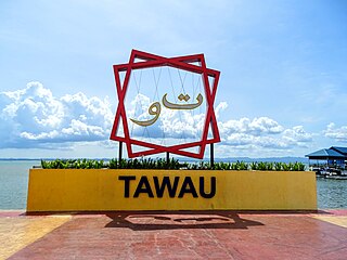
Tawau, formerly known as Tawao, is the capital of the Tawau District in Sabah, Malaysia. It is the third-largest city in Sabah, after Kota Kinabalu and Sandakan. It is located on the Semporna Peninsula in the southeast coast of the state in the administrative centre of Tawau Division, which is bordered by the Sulu Sea to the east, the Celebes Sea to the south at Cowie Bay and shares a border with North Kalimantan, Indonesia. The town had an estimated population as of 2010, of 113,809, while the whole municipality area had a population of 397,673. The municipal area had a population of 372,615 at the 2020 Census.
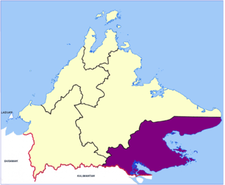
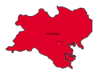
Tawau Division is one of the five administrative sub-divisions of Sabah, Malaysia. It occupies a total of 14,905 square kilometres or 20% of Sabah's territory. The main towns include the capital of Tawau, Lahad Datu, Kunak and Semporna. Tawau division has 26% of Sabah's total population, with the main indigenous groups consisting of the Bajau, Suluk, Ida'an, Tidong, Cocos, Murut, Lun Bawang/Lun Dayeh as well as a minority of mixed ethnic groups. Large numbers of both legal and illegal immigrants from Indonesia such as the Buginese and Torajans, from East Timor the Timorese, from the Philippines the Tausūg and Visayans as well South and West Asian immigrants such as Pakistanis, Indians and Arabs can be found in this area. As with the rest of Sabah, the division also has large numbers of ethnic Chinese.

Keningau is the capital of the Keningau District in the Interior Division of Sabah, Malaysia. It is the fifth-largest town in Sabah, as well one of the oldest. Keningau is between Tambunan and Tenom. The town had an estimated population of 173,130. Dusuns, Muruts and Lundayehs is the major ethnics in Keningau.

Tawau Hills Park, was established in 1979, primarily as a protection for the water catchment area of Tawau town, Sabah, Malaysia. It is located 24 kilometres from Tawau, and comprises 279.72 km² of lowland dipterocarp rainforest, surrounded by oil palm and cacao plantations. The park offers picnic areas, camping sites, and chalets. The Park contains rugged volcanic landscapes including a hot spring and spectacular waterfalls. The highest point in the park is Gunung Magdalena. It is administered by the Sabah Parks.

Tawau Airport is an airport located 15 nautical miles north east of Tawau, Sabah, Malaysia. It is one of two airports in Sabah with immigration counters for international flights, the other being Kota Kinabalu International Airport.
The Murutic languages are a family of half a dozen closely related Austronesian languages, spoken in the northern inland regions of Borneo by the Murut and Tidung.

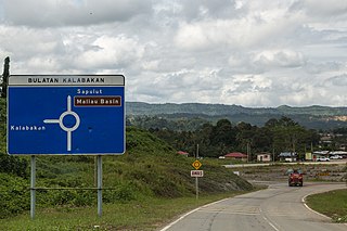
Sapulut is a town along Sapulut River in the Interior Division of Sabah, Malaysia. Mount Antulai is located about 5 kilometres from the town. Nearby the town is the Batu Punggul limestone massif and cave, a popular spot for eco-tourists. The proposed new highway connecting Sapulut and Kalabakan in the Tawau Division is expected to be completed in mid-2007, and when completed will make road travel between Kota Kinabalu and Tawau easier and faster.

Sook is a small located in the Interior Division, Sabah, Malaysia. It serves as a timber and agricultural town as well as a transit town for motorists travelling from Keningau to Tawau via the Keningau-Sook-Sapulut-Kalabakan-Tawau road.
Serudung Murut, or Serudung, is a Sabahan language spoken by members of the Tidong ethnic group in Kalabakan District, Sabah, Malaysia.
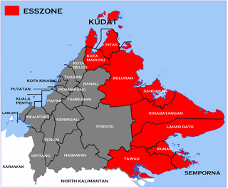
The Eastern Sabah Security Zone (ESSZONE) is a security zone in the Malaysian state of Sabah that was launched by Malaysian Prime Minister Najib Razak on 25 March 2013 following persistent attacks by pirates and militants from the southern Philippines that occurred in the eastern part of Sabah especially after the 2013 Lahad Datu standoff. It includes the districts of Kudat, Kota Marudu, Pitas, Beluran, Sandakan, Kinabatangan, Lahad Datu, Kunak, Semporna and Tawau, which is neighbouring to the Philippines.
Tawau Municipal Council is the municipal council which administrates the town and municipalities area of Tawau in the state of Sabah, Malaysia.

In April 1963, the first recorded infiltration and attack occurred in Borneo as part of the wider Indonesia–Malaysia confrontation. An infiltration force training at Nangabadan was split in two and prepared for its first operation.

Tawau Japanese War Memorial is a former Japanese cemetery in Tawau in the Malaysian state of Sabah which has been transformed into a memorial.

Kalabakan is a federal constituency in Tawau Division, Sabah, Malaysia, that has been represented in the Dewan Rakyat since 2004.

The Tawau Bell Tower is the oldest standing structure in Tawau, constructed by the Japanese to commemorate the signing of armistice agreement following World War I when Japan was an ally of Great Britain.

The Tawau District is an administrative district in the Malaysian state of Sabah, part of the Tawau Division which also includes the districts of Kunak, Lahad Datu, Semporna and Tawau. The capital of the district is in Tawau Town. The district also includes the northern half of Sebatik Island, which is shared with Indonesia's North Kalimantan province.
Ma'mun bin Sulaiman is a Malaysian politician who served as the Member of Parliament (MP) for Kalabakan from May 2018 to November 2022. He is a Supreme Council member of the Heritage Party (WARISAN).
Kalabakan is a district in the Malaysian state of Sabah, located approximately 235 kilometres (146 mi) southeast of the state capital of Kota Kinabalu. It recorded a population of 48,195 people in the 2020 Malaysian census. Its capital is the town of Kalabakan.
The Battle of Kalabakan was a significant military confrontation during the Indonesia–Malaysia confrontation. It took place on December 29, 1963, in the Kalabakan region of Sabah, located on the island of Borneo, which was part of Malaysia