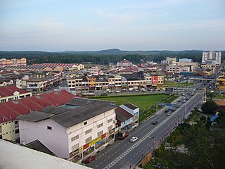
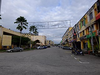
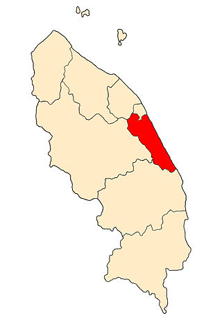
Ajil (est. pop. (2000 census): 1,842) [1] is a small town in the Penghulu Diman commune in Hulu Terengganu District of Terengganu, Malaysia.

Ajil (est. pop. (2000 census): 1,842) [1] is a small town in the Penghulu Diman commune in Hulu Terengganu District of Terengganu, Malaysia.
The town is located 35 km south of Kuala Terengganu, the state capital, near the intersection of Federal Route 14 (Terengganu's main interior highway) and Federal Route 106 (the main highway to Kuala Berang). Ajil is also home to a migrant detention centre where illegal immigrants are detained. [2]

Transportation in Malaysia started to develop during British colonial rule, and the country's transport network is now diverse and developed. Malaysia's road network is extensive, covering 290,099.38 kilometres, including 2,016.05 km of expressways. The main highway of the country extends over 800 km, reaching the Thai border from Singapore. Peninsular Malaysia has an extensive road network, whilst the road system in East Malaysia is not as well-developed. The main modes of transport in Peninsular Malaysia include buses, trains, cars and to an extent, commercial travel on airplanes.

Kuala Terengganu, colloquially referred to as KT, is the administrative, economic and royal capital of the state of Terengganu, Malaysia. Kuala Terengganu is also the capital of Kuala Terengganu District. It is also the only royal capital among the nine royal states of the country to bear its state's name. Kuala Terengganu is located about 440 kilometres northeast of Kuala Lumpur on the East Coast of Peninsular Malaysia. The city is situated at the estuary of Terengganu River, facing the South China Sea.
Kota Tinggi is a town and capital of Kota Tinggi District, Johor, Malaysia. Kota Tinggi is also the name of the district, Kota Tinggi District, where the town is situated. Kota Tinggi is the largest district in Johor.

Mersing is a town, mukim and the capital of Mersing District, Johor, Malaysia.
The East Coast Expressway is an interstate controlled-access highway running parallel to the northeastern coast of Peninsular Malaysia. The currently operational 433-kilometre (269-mile) segment of the expressway runs between Karak, Pahang and Kuala Nerus, Terengganu.
The Federal Route 1 is the first federal road in Malaysia, the oldest federal road in Malaysia, and among the nation's earliest public roadways ever constructed. The Federal Route 1 was the backbone of the road system in the western states of Peninsular Malaysia before being supplanted by the North–South Expressway.
Federal Route 3 is a main federal road running along the east coast of Peninsula Malaysia. The 739 kilometres (459 mi) federal highway connects Rantau Panjang in Kelantan until Johor Bahru in Johor. The entire FT3 highway is gazetted as a part of the Asian Highway Network route 18.
Jerangau–Jabor Highway, Federal Route 14 is a 179.63-km federal highway running from the city of Kuala Terengganu, Terengganu, Malaysia to Kuantan, Pahang. The highway runs in parallel with the Federal Route 3 - while the FT3 highway is a coastal highway, the Jerangau–Jabor Highway FT14 runs through the interior area instead. Although the distance from Kuala Terengganu to Kuantan via both FT3 and FT14 highways are about the same, the Jerangau–Jabor Highway FT14 significantly shortens the travelling time due to fewer towns being passed. Therefore, the Jerangau–Jabor Highway FT14 became the main route from Pahang to Terengganu before the advent of the East Coast Expressway Phase 2 E8.
Second East–West Highway, also known as Simpang Pulai–Kuala Berang Highway, Federal Route 185 and Federal Route 36, is a highway in Peninsular Malaysia which connects Simpang Pulai in Perak to Kuala Jeneris in Terengganu. It overlaps with Federal Route 8 Federal Route 8 between Gua Musang and Sungai Relau. It is notorious for its many sharp corners which increase the risk of road accidents.

The Rompin District is a district located in the southeastern corner of Pahang, Malaysia. Rompin is currently under the Rompin District Council.

Gerik is a mukim and the district capital of Hulu Perak District, Perak, Malaysia. The town is also known as Rest Town owing to its strategic location next to East-West Highway Federal Route 4, the main route linking Kedah, Penang and Kelantan.
Chukai, also known by the name of Kemaman Town is a mukim and capital of Kemaman District, Terengganu, Malaysia.

Kuala Berang is the seat and largest town of Hulu Terengganu District, Terengganu, Malaysia. The town serves as a gateway to Lake Kenyir. The historical Terengganu Inscription Stone was found near Kuala Berang in 1899. The town of Kuala Berang was the first capital of the modern Sultanate of Terengganu before moving to Kuala Terengganu.
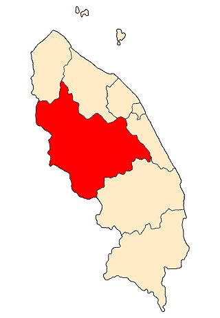
Hulu Terengganu is an interior district of Terengganu, Malaysia. The seat of the district is Kuala Berang, located about 40 km (25 mi) from the state capital, Kuala Terengganu. The local government of this district is Hulu Terengganu District Council.
Marang is a town and the seat of Marang District, in the state of Terengganu, Malaysia. The town is located on the South China Sea coast on the main highway between Kuala Terengganu and Kuantan. The main economic activity in Marang is fishery and tourism.
The Marang District is a coastal district in Terengganu, Malaysia. The district seat is the town of Marang. The districts that border Marang are Kuala Terengganu and Kuala Nerus to the north, Hulu Terengganu in the west, while Dungun is in the south. The eastern part of the district is a stretch of coastline facing the South China Sea.
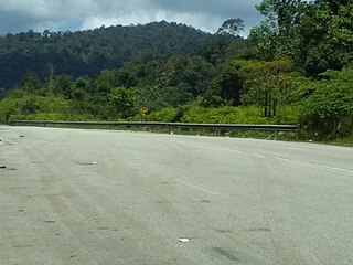
Federal Route 106, or Jalan Ajil-Kuala Berang, is a dual-carriageway federal highway in Terengganu, Malaysia.

The Malaysian Expressway System is a network of national controlled-access expressways in Malaysia that forms the primary backbone network of Malaysian national highways. The network begins with the Tanjung Malim–Slim River tolled road which was opened to traffic on 16 March 1966, later North–South Expressway (NSE), and is being substantially developed. Malaysian expressways are built by private companies under the supervision of the government highway authority, Malaysian Highway Authority.
Federal Route 247, or Jalan Sungai Tong-Kuala Berang, is a federal road in Terengganu, Malaysia. It is a main route to Second East-West Highway. The Kilometre Zero is at Sungai Tong in Setiu constituency.
State of Terengganu | |
|---|---|
Capital: Kuala Terengganu | |
| Topics | |
| Society | |
| Administrative divisions | |
5°05′N103°05′E / 5.083°N 103.083°E
| | This article about a location in the Sultanate of Terengganu is a stub. You can help Wikipedia by expanding it. |