
Terengganu, formerly spelled Trengganu or Tringganu, is a sultanate and federal state of Malaysia. The state is also known by its Arabic honorific, Dāru l-Īmān. The coastal city of Kuala Terengganu, at the mouth of the Terengganu River, is both the state and royal capital as well as the most populous city in Terengganu. Other major cities and towns include Jerteh, Kuala Dungun, Chukai, Kuala Berang, Marang, and Permaisuri. At 13,035 square kilometres in size and a population of over 1.2 million people in 2023, Terengganu is Malaysia's 7th largest state and 10th most populated. Terengganu, along with Kelantan, Perlis, and the Federal Territory of Putrajaya, is one of the most homogeneous states/territories in the country of which 95% of the population are ethnic Malay-Muslims with its own distinct language/dialect, culture, history, and tradition.

Kuala Terengganu, colloquially referred to as KT, is the administrative, economic and royal capital of the state of Terengganu, Malaysia. Kuala Terengganu is also the capital of Kuala Terengganu District. It is also the only royal capital among the nine royal states of the country to bear its state's name. Kuala Terengganu is located about 440 kilometres northeast of Kuala Lumpur on the East Coast of Peninsular Malaysia. The city is situated at the estuary of Terengganu River, facing the South China Sea.

Dungun is a coastal district of the Malaysian state of Terengganu. Kuala Dungun is the capital of the district. Dungun is made up of eleven 'mukim', or subdistricts: Abang, Besol, Jengai, Jerangau, Kuala Dungun, Kuala Paka, Kumpal, Pasir Raja, Rasau, Sura, and Hulu Paka.

Lang Tengah Island is an island in Kuala Nerus District, Terengganu, Malaysia. It is connected to the mainland by ferries to Merang.

The Pahang River mainly flows through the state of Pahang, Malaysia. Its drainage basin covers its Pahang as well as the neighbouring state of Negeri Sembilan.

Mersing is a town, mukim and the capital of Mersing District, Johor, Malaysia. The town is located at the southern end of the east coast of Peninsular Malaysia. As of 2010, the town has an estimated population of 70,894.

Kapas Island is an island in Marang District, Terengganu, Malaysia, with a smaller island, Pulau Gemia, located north of it. It measures roughly 1.5 by 2.5 km. Its name, Pulau Kapas, refers to the island's white beaches. The island has tropical jungle, clear seawater, white sand beaches and coral reefs in the surrounding waters. It is promoted as a "diving and snorkeling paradise". The island is reached by ferry from Marang. Kapas is the location where most of the research on the enigmatic Amphidromus snails is carried out.
Wakaf Tapai is a small town in Marang District, Terengganu, Malaysia.

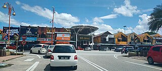
Paka is a coastal town facing the South China Sea in Dungun District, Terengganu, Malaysia.

Kawthaung is a border town located in the southernmost part of Myanmar, in the Tanintharyi Region. During British rule in Burma between 1824 and 1948, it was known as Victoria Point. As of 2021, it has a population of 57,949. Facing Ranong in Thailand, Kawthaung is one of 7 official border trade posts with Thailand.
Kuala Berang is the seat and largest town of Hulu Terengganu District, Terengganu, Malaysia. The town serves as a gateway to Kenyir Lake. The Terengganu Inscription Stone was found near Kuala Berang in 1899. The town of Kuala Berang was the first capital of the modern Sultanate of Terengganu before moving to Kuala Terengganu.
Beserah is one of the Pahang state legislative assemblies located in Indera Mahkota, Kuantan District, Pahang, Malaysia and its position between the cities of Kuantan and Chukai with estimated total land area 300 square kilometers about almost same size with Federal Territories of Malaysia and two times larger than Liechtenstein. There are two mukim within this state assembly; mukim Beserah and mukim Sungai Karang.

Ajil is a small town in the Penghulu Diman commune in Hulu Terengganu District of Terengganu, Malaysia.
Merchang is a town in a sub-district of the same name in Marang District, Terengganu, Malaysia. Fishery and agriculture are the main economic activities in Merchang, Marang, Terengganu.
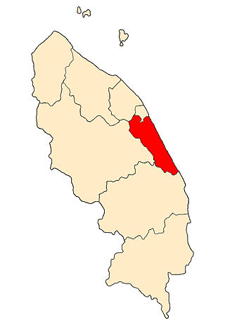
The Marang District is a coastal district in Terengganu, Malaysia. The district seat is the town of Marang. The districts that border Marang are Kuala Terengganu and Kuala Nerus to the north, Hulu Terengganu in the west, while Dungun is in the south. The eastern part of the district is a stretch of coastline facing the South China Sea.

Bukit Payong is a town Marang District, Terengganu, Malaysia.

Terengganu Malay is a Malayic language spoken in the Malaysian state of Terengganu all the way southward to coastal Pahang and northeast Johor. It is the native language of Terengganu Malays and highly localized Chinese Peranakan community as well as a second language among the smaller Indian minority.

Kampung Cina, is a Chinatown located in Kuala Terengganu, Terengganu, Malaysia. Kampung Cina is located along Jalan Bandar, in Kuala Terengganu city centre at the river mouth of Terengganu River that empties into the South China Sea. Kampung Cina literally means Chinese Village; it is also called Tn̂g-lâng-pho (唐人坡) or KT's Chinatown by local people. It is one of Southeast Asia's early Chinese settlements and contains stately ancestral homes, temples, townhouses, and business establishments. The town is small but has colourful shophouses along both sides of the road that carries traditional flavour.

The East Coast Rail Link (ECRL) is a standard gauge double-track railway link infrastructure project connecting Port Klang on the Straits of Malacca to Kota Bharu in northeast Peninsular Malaysia, connecting the East Coast Economic Region states of Pahang, Terengganu and Kelantan to one another, and to the Central Region of the Peninsula's west coast.


