The Tunku Abdul Rahman National Park (Malay: Taman Negara Tunku Abdul Rahman) comprises a group of 5 islands located between Kota Kinabalu in Sabah, Malaysia. The park is spread over 4,929 hectares, two-thirds of which cover the sea. Before the Ice age, it formed part of the Crocker Range mass of sandstone and sedimentary rock on the mainland. However, about one million years ago, the melting ice brought about changes in the sea level and parts of the mainland were cut off by the sea to form the islands of Gaya, Sapi, Manukan, Mamutik and Sulug. Evidence of this can be seen from the exposed sandstone of the coastline forming the cliffs, caves, honeycombs and deep crevices. The park was named after Tunku Abdul Rahman, Malaysia's first Prime Minister.
Jesselton Point Ferry Terminal in downtown Kota Kinabalu is the ferry terminal for those heading to the islands in Tunku Abdul Rahman National Park (Gaya, Sapi, Manukan, Mamutik and Sulug). This ferry terminal is also the departure point for patrons staying at either Manukan Island Resort, Gayana Resort or Bunga Raya Resort
Climate
Temperatures are between 23.8 and 29.4 degrees Celsius all year round. Humidity remains relatively high throughout the year.
Geology
The islands are underlaid by folded sandstone and sedimentary rock, are part of the Crocker Rangerock formation of the western coast of Sabah. Towards the end of Ice Age happened about one million years ago, changes of the sea level occurred, resulting in portions of the mainland being cut off by the sea, thus forming the islands today. Exposed sandstone outcrops still feature the coasts of most of these islands forming cliffs, caves, honeycombs and deep crevasses along the shore.
Gaya Island derived its name from the Bajau word "Gayo" which means big and occupies an area of 15km2 (3,700 acres) with an elevation of up to 300 metres. Several ridges rise more than 600 feet (180 m), peaking at 1,000 feet (300 m), along the backbone of Gaya Island.
Gaya island is the largest island in the park, closest to downtown Kota Kinabalu (KK) and is covered with dense virgin, tropical forest. It has been a forest reserve since 1923. The island has 20km of hiking trails and two 5 star resorts named Gayana Eco Resort, home to the Marine Ecology Research Centre, and Bunga Raya Island Resort on the north-east part of the island.
Another resort is being constructed on what used to be Hornbill Bay near Gayana Eco Resort.
Gaya island is also host to a very large (and growing) stilt village located just opposite the KK waterfront. This village is occupied by illegal immigrants from the Philippines and is considered a dangerous, high crime or "no-go" area by the police and KK locals.
Sabah Parks, the body charged with protecting the Tunku Abdul Rahman Park, is headquartered on the south-eastern part of Gaya Island in a bay shared with the Downbelow Marine & Wildlife Adventures dive station. A development on the edge of Gaya island nearest to Sapi island is also used by Sabah Parks and offers a small, quiet beach for public recreational use.
Gaya island is also known for a legendary beach at Police Bay. The 400 metres (0.25-mile) stretch of white sand, gently slopes out to the sea and makes Police Beach ideal for swimming in the crystal clear water. Police Beach fronts the upmarket Bunga Raya Island Resort.
The coral reefs along the entire coast of Gaya island are in excellent condition, making it a surprisingly good diving destination, considering its proximity to Kota Kinabalu city.
An aerial view of Mamutik (top left), Sulug (top right) and Manukan (bottom) resembling a smiling face.
The second largest island in the park, Manukan is the most popular with Kota Kinabalu residents. Manukan has some good stretches of beaches on the southern coastline. The best beach is on the eastern tip of the island. Offshore of Manukan are coral reefs, which is ideal for snorkelling, diving and swimming.
Out of 5 islands, Manukan features the most developed tourist facilities that includes 20 units of chalets, a clubhouse, and few restaurants and a diving centre. Recreation facilities include a swimming pool, football field, Volleyball and Sepak Takraw courts. Infrastructural facilities include support-water, electricity, desalination plant, sewerage system, and even a solar public telephone. It is covered in dense vegetation and has hiking trails.
Mamutik Island
The 15 acres (6.1ha) island makes Mamutik the smallest of the park. Despite being the smallest, the island offers some good beaches and coral reefs. It also has a jetty, a 3-bedroom resthouse for rent, and staff quarters for Rangers station. Facilities include changing rooms, toilets, picnic shelters, tables and barbecue pits. Fresh water and electricity are available. Mamutik would be an ideal venue to get away from it all. The corals to the north-eastern tip of the island are quite interesting. The beach is rocky and swimmers must be careful of sea urchins that exist in large numbers beside the corals and rocks.
Sapi Island
Sapi Island
Sapi Island, literally known as "Cow Island" in Malay is just off the south-western tip of Gaya Island. The 25-acre (10ha) island features one of the nicest beaches in the park and most popular with tourists for snorkelling and scuba diving. Between 10am and 4pm the island gets quite busy with foreign tourists but after the last ferry leaves it becomes a tranquil island with only those staying overnight. It is developed with tourist facilities that includes a jetty, picnic shelters, barbecue pits, tables, changing rooms and toilets. The forest is inhabited by macaques. Camping and campfires are allowed with the permission from the park warden.
Sulug is the farthest island of them all. Considered relatively untouched, remote and undeveloped, the 20-acre (8.1ha) island is more popular with foreign tourists who prefer a quiet and tranquil atmosphere. Good reef patches lie along the southern end of the island.
During formation, a long sand spit jutting out into the ocean formed a round hill.
History
In 1882, the British North Borneo Company set up a trading settlement on Gaya Island called Api-Api. The settlement was later moved to the mainland and been named Jesselton after Sir Charles Jessel. In 1968, Jesselton was renamed Kota Kinabalu.
In 1974, the major part of Gaya and Sapi islands was gazetted as Tunku Abdul Rahman Park, covering an area of 8,990 acres (36.4km2). In 1979, the park was increased to 12,185 acres (49.31km2) with the inclusion of the three nearby islands of Manukan, Mamutik and Sulug.
Kota Kinabalu is the state capital of Sabah, Malaysia. It is also the capital of the Kota Kinabalu District as well as the West Coast Division of Sabah. The city is located on the northwest coast of Borneo facing the South China Sea. The Tunku Abdul Rahman National Park lies to its west and Mount Kinabalu, which gave the city its name, is located to its east. Kota Kinabalu has a population of 452,058 according to the 2010 census; when the adjacent Penampang and Putatan districts are included, the metro area has a combined population of 628,725.
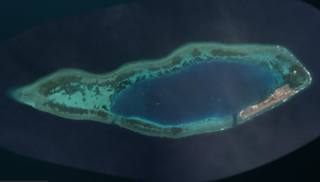
Tiga Island is one of a group of small uninhabited islands in Kimanis Bay off the western coast of Sabah, Malaysia. The islands were formed on 21 September 1897, when an earthquake on Mindanao caused a volcanic eruption near Borneo. The island is 607 hectares in size and has a couple of active mud volcanos at the highest part of the island. Tiga Island is one of the three islands that make up Tiga Island National Park. The Park Headquarters are on the island, comprising an office complex, and accommodation for the park staff and visiting scientists.
Sabah Parks is a conservation-based statutory body established in 1964 with the purpose of conserving the scenic, scientific and historic heritage of the state of Sabah, Malaysia, on the island of Borneo. The organisation is also responsible for the management and promotion of the various protected reserves in Sabah, in particular those designated as national parks. It is also mandated to develop tourism-friendly facilities to accommodate tourist arrivals to these reserves and ensure that the state of the reserves is not compromised. The first choice for inclusion in a park system was Mount Kinabalu. As a result, Kinabalu Park was gazetted in 1964, and today it is designated as a World Heritage Site.
Mabul is a small island off the south-eastern coast of Sabah in Malaysia. The island has been a fishing village since the 1970s. In the 1990s, it first became popular to divers due to its proximity to Sipadan island.
Kapalai is an island in Tawau Division, Sabah, Malaysia, known for its scuba resorts.
Sabah Air Aviation Sdn Bhd, trading as SabahAir, is an airline based in the Sabah Air Building in Kota Kinabalu, Sabah, Malaysia.
Gaya Island is a sizeable Malaysian island of 1,465 ha, just 10 minutes off Kota Kinabalu, Sabah and forms part of the Tunku Abdul Rahman National Park. Gaya Island derived its name from the Bajau word "Gayo" which means big and occupies an area of 15 km2 with an elevation of up to 300 metres. Several ridges rise more than 600 feet, peaking at 1,000 feet, along the backbone of Gaya Island.
Swallow Reef, also known as Malay: Pulau Layang-Layang; Vietnamese: Đá Hoa Lau; Mandarin Chinese: 燕子島; pinyin: Yànzi Dǎo; Celerio Reef, is an oceanic atoll of the Spratly Islands administered by Malaysia, which is situated approximately 300 kilometres (190 mi) northwest of Kota Kinabalu, Sabah. The atoll is about 7 km long and 2 km wide with a central lagoon. The part of the atoll above sea level is a reef on the south-east rim which had an original land area of approximately 6.2 hectares, but with reclaimed land now covers 35 hectares, measuring over 1.5 kilometres (0.93 mi) long and 200 m (656 ft) wide.
Malaysia was once ranked 9th in the world for tourist arrivals. The Travel and Tourism Competitiveness Report 2017 ranks Malaysia 25th out of 141 countries overall.
Tanjung Aru is a sub-district of Kota Kinabalu in Sabah, of Malaysia. Its main feature is its beach called Tanjung Aru Beach which stretches to over 2 kilometres long along with new skyscrapers.
Pom Pom Island is a small coral reef island in the Celebes Sea approximately 30 kilometres north east of Semporna town, Sabah, East Malaysia.
Manukan Island is the second largest island in the Tunku Abdul Rahman National Park, Malaysia's first marine national park. It is located in the East Malaysian state of Sabah, just off the coast of Kota Kinabalu and is easily accessible by boat.
Greater Kota Kinabalu refers to the dense clusters of regional populated areas surrounding the city of Kota Kinabalu in Malaysia. It comprises the districts of Kota Kinabalu, Penampang, Tuaran and Papar. These districts are also part of the West Coast Division. It was forecasted that in 2019, the combined population of these districts was 1.1 million people, in a combined area of 3,277 km2.
Sulug Island is an island located in the West Coast of Sabah, Malaysia. The island is part of the Tunku Abdul Rahman National Park.
Suria Sabah is a shopping centre located in the city of Kota Kinabalu, Sabah, Malaysia. Completed in July 2009, the mall sits on an 11-acre site facing the South China Sea with a scenic view of the Tunku Abdul Rahman National Park.
Sutera Harbour is a resort located in the city of Kota Kinabalu, Sabah, Malaysia. It comprised two 5-star hotels, a 27-hole Graham Marsh-designed golf course, a 104-berth marina and an exclusive golf and country club with extensive recreational facilities facing the South China Sea with a background of Tunku Abdul Rahman National Park. In 2014, Singapore-based GSH Corporation has acquired the resort.
The Mengalum Island boat accident is occurred on 28 January 2017, when a catamaran passenger ferry sank in the South China Sea off Mengalum Island in Sabah, Malaysia. The boat was carrying 27 Chinese tourists, of whom 22 were rescued, four confirmed dead, and five still missing.
The Penampang District is an administrative district in the Malaysian state of Sabah, part of the West Coast Division which includes the districts of Kota Belud, Kota Kinabalu, Papar, Penampang, Putatan, Ranau and Tuaran. The capital of the district is in Penampang Town.
This page is based on this Wikipedia article Text is available under the CC BY-SA 4.0 license; additional terms may apply. Images, videos and audio are available under their respective licenses.