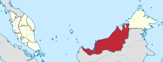
Sarawak is a state of Malaysia. The largest among the 13 states, with an area almost equal to that of Peninsular Malaysia, Sarawak is located in East Malaysia in northwest Borneo, and is bordered by the Malaysian state of Sabah to the northeast, Kalimantan to the south, and Brunei in the north. The state capital, Kuching, is the largest city in Sarawak, the economic centre of the state, and the seat of the Sarawak state government. Other cities and towns in Sarawak include Miri, Sibu, and Bintulu. As of the 2020 Malaysia census, the population of Sarawak was 2.453 million. Sarawak has an equatorial climate with tropical rainforests and abundant animal and plant species. It has several prominent cave systems at Gunung Mulu National Park. Rajang River is the longest river in Malaysia; Bakun Dam, one of the largest dams in Southeast Asia, is located on one of its tributaries, the Balui River. Mount Murud is the highest point in the state. Sarawak is the only state of Malaysia with a Christian majority.
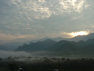
The Gunung Mulu National Park, also known simply as the Mulu National Park is a national park in Miri Division, Sarawak, Malaysia. It is a UNESCO World Heritage Site that encompasses caves and karst formations in a mountainous equatorial rainforest setting. The park is famous for its caves and the expeditions that have been mounted to explore them and their surrounding rainforest, most notably the Royal Geographical Society Expedition of 1977–1978, which saw over 100 scientists in the field for 15 months. This initiated a series of over 20 expeditions now named the Mulu Caves Project.

Miri Division is one of the twelve administrative divisions of Sarawak, Malaysia.

Bruno Manser was a Swiss environmentalist and human rights activist. From 1984 to 1990, he stayed with the Penan tribe in Malaysia, organising Indigenous rainforest blockades in Sarawak against timber companies. After he emerged from the forests in 1990, he engaged in public activism for rainforest preservation and the human rights of indigenous peoples, especially the Penan, which brought him into conflict with the Malaysian government. He also founded the Swiss non-governmental organization (NGO) Bruno Manser Fonds in 1991. Manser disappeared during his last journey to Sarawak in May 2000 and is presumed dead.
Nepenthes lowii, or Low's pitcher-plant, is a tropical pitcher plant endemic to Borneo. It is named after Hugh Low, who discovered it on Mount Kinabalu. This species is perhaps the most unusual in the genus, being characterised by its strongly constricted upper pitchers, which bear a greatly reduced peristome and a reflexed lid with numerous bristles on its lower surface.

Mount Murud or Muru is a sandstone mountain located in Limbang Division, Sarawak, Malaysia At 2,424 m (7,946 ft), it is the highest mountain in Sarawak.
The Kelabit Highlands are a mountain range located in the northernmost part of Sarawak, Malaysia in the Miri Division. It hosts the Bario village. The highest mountains in this range are Mount Murud at 2,423 metres (7,949 ft), Bukit Batu Buli at 2,082 metres (6,831 ft), and Bukit Batu Lawi at 2,046 metres (6,713 ft). The current population of the Kelabit people is about 6,800.
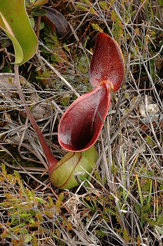
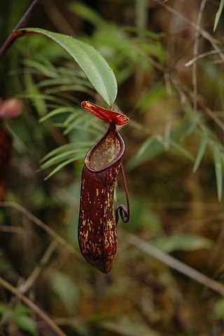
Nepenthes murudensis, or the Murud pitcher-plant, is a tropical pitcher plant endemic to Mount Murud in Borneo, after which it is named. It is of putative hybrid origin: its two original parent species are thought to be N. reinwardtiana and N. tentaculata.
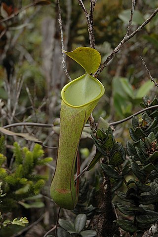
Nepenthes muluensis, or the Mulu pitcher-plant, is a tropical pitcher plant endemic to Borneo. It grows in highland habitats at elevations of 1700 to 2400 m above sea level.

Batu Lawi is a twin-peaked mountain in the Kelabit Highlands of Sarawak, Malaysia (Borneo) that has played important roles in both ancient mythology and modern history. The taller 'male' peak is 2046 metres above sea level, while the female summit is at 1850 metres. It is one of the highest mountains in the state of Sarawak.

Ba'kelalan is a group of nine villages at Maligan Highlands of Limbang Division, Sarawak, Malaysia about 3,000 feet (910 m) above sea level and 4 km from the border with Indonesian Kalimantan and 150 km from the nearest town of Lawas. There are nine villages in Ba'kelalan. The villagers here belong to the Lun Bawang tribe.

The Lun Bawang is an ethnic group found in Central Northern Borneo. They are indigenous to the southwest of Sabah and the northern region of Sarawak, highlands of North Kalimantan and Brunei.

Bario is a community of 13 to 16 villages located on the Kelabit Highlands in Miri Division, Sarawak, Malaysia, lying at an altitude of 1000 m (3280 ft) above sea level. It is located close to the Sarawak-Kalimantan border, 178 km to the east of Miri. It is the main settlement for the indigenous Kelabit tribe. There are regular flights between the Bario, Miri and Marudi.

The Limbang District is one of the two districts of Limbang Division, Malaysia. It has a total area of 3,978.10 square kilometres. The major town is Limbang. It has one sub-district, which is Nanga Medamit Sub-District. It borders Brunei Darussalam to the west and east, Lawas District to the southeast and Miri District at the south and southwest. Due to being squeezed in between Brunei at its north and coastal areas, Limbang is accessible by road only by going through immigration posts.
Pelophryne linanitensis, also known as the Linanit dwarf toad, is a species of toad in the family Bufonidae. It is endemic to Batu Linanit in Mount Murud in Sarawak, Borneo.
Pelophryne murudensis, also known as the Murud dwarf toad, is a species of toad in the family Bufonidae. It is endemic to Mount Murud in Sarawak, Borneo.
Ansonia vidua is a species of toads in the family Bufonidae. It is endemic to Sarawak, Borneo. Common names Murud black slender toad and widow slender toad have been coined for this little known species. The latter name refers to the black colouration of this species and the fact that no male individuals are known.
Katharine Georgina "Kit" Pearce, is a British botanist and forest ecologist.
Indigenous rainforest blockades in Sarawak began during the late 1980s and 1990s. In response to deforestation and land conversion of Sarawak's forest landscapes, Indigenous people of several groups along with international activists organised blockades to resist logging activities and dam construction. Penan, Kayan and Kelabit people are among the groups who participated. Some blockades were dismantled by police and some participants were arrested. Indigenous people have continued to hold blockades into the 21st century.

