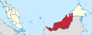
Sarawak is a state of Malaysia. The largest among the 13 states, with an area almost equal to that of Peninsular Malaysia, Sarawak is located in the region of East Malaysia in northwest Borneo, and is bordered by the Malaysian state of Sabah to the northeast, Kalimantan to the south, and Brunei in the north. The state capital, Kuching, is the largest city in Sarawak, the economic centre of the state, and the seat of the Sarawak state government. Other cities and towns in Sarawak include Miri, Sibu, and Bintulu. As of the 2020 Malaysia census, the population of Sarawak was 2.453 million. Sarawak has an equatorial climate with tropical rainforests and abundant animal and plant species. It has several prominent cave systems at Gunung Mulu National Park. Rajang River is the longest river in Malaysia; Bakun Dam, one of the largest dams in Southeast Asia, is located on one of its tributaries, the Balui River. Mount Murud is the highest point in the state. Sarawak is the only state of Malaysia with a Christian majority.

Sibu is a landlocked city located in the central region of Sarawak, Malaysia. It serves as the capital of Sibu District within Sibu Division and is situated on the island of Borneo. Covering an area of 129.5 square kilometres (50.0 sq mi), the city is positioned at the confluence of the Rajang and Igan Rivers, approximately 60 kilometres from the South China Sea and 191.5 kilometres (119 mi) north-east of the state capital, Kuching.

Miri is a coastal city in north-eastern Sarawak, Malaysia, located near the border of Brunei, on the island of Borneo. The city covers an area of 997.43 square kilometres (385.11 sq mi), located 798 kilometres (496 mi) northeast of Kuching and 329 kilometres (204 mi) southwest of Kota Kinabalu. Miri is the second largest city in Sarawak, with a population of 356,900 as of 2020. The city is also the capital of Miri District, Miri Division.

Kapit Division, formed on 2 April 1973, is one of the twelve administrative divisions in Sarawak, Malaysia. It has a total area of 38,934 square kilometres, and is the largest of the administrative divisions of Sarawak.

Bintulu Division is one of the twelve administrative divisions of Sarawak, Malaysia. It has a total area of 12,166.2 square kilometres, and is the third largest division after Kapit Division and Miri Division. Bintulu Division consists of two districts which is Bintulu and Tatau, together with a sub-district under Bintulu, which is Sebauh. Three major towns in Bintulu are Bintulu, Tatau and Sebauh.

Tatau is a town, and the capital of the Tatau District in Bintulu Division, Sarawak, Malaysia. The district's reported total population for Tatau was 30,383. Tatau became a district in 1987. Before that it was a Sub District under Bintulu District. The main spoken languages are Iban, Kenyah, Beketan and Punan.

Miri Division is one of the twelve administrative divisions of Sarawak, Malaysia.
The Skudai River is located in Johor, Malaysia. Its main tributary originated from a small creek within an oil palm plantation in Kg. Sedenak, Kulai, then flowing south-ward towards the Johor Bahru city. Its river mouth is located in Danga Bay, Tampoi discharging its water to the narrow Tebrau Straits. The length of its main tributary is about 43 km, whilst the overall tributaries length is approximately 308 km. The Skudai River Basin (SRB) comprises 270 km2 of land, divided into 22 sub-catchments. It is within the jurisdiction area of Kulai Municipal Council (MPKu), Iskandar Puteri CIty Council (MBIP), and Johor Bahru CIty Council (MBJB). Among its main tributaries and sub-catchments are the Danga River (15.3 km), Melana River (15.9 km), Senai River (10.4 km), Anak Sungai Melana (5.8 km), UTM River (5.3 km), Kempas River (4.8 km), and Sri Sengkang River (8.4 km). This network of streams flows through several towns, huge residential establishments and several industrial parks, making them susceptible to pollution. The Danga River and Kempas River have been identified as the most polluted tributaries within SRB.

The Kemena River is a river in Bintulu Division, Sarawak state, Malaysia. It flows past Sebauh and Bintulu, and is used for transporting timber and oil from the interior.
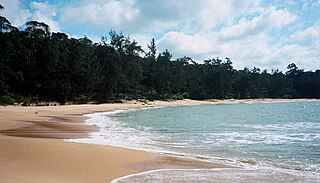
Similajau National Park, is a national park in the Bintulu Division of Sarawak, Malaysia. It is located about 30 kilometres (19 mi) from Bintulu.
Bukit, the Indonesian or Malay word for hill, may refer to:

Bintulu is a coastal town on the island of Borneo in the central region of Sarawak, Malaysia. Bintulu is located 610 kilometres northeast of Kuching, 216 kilometres northeast of Sibu, and 200 kilometres southwest of Miri. With a population of 114,058 as of 2010, Bintulu is the capital of the Bintulu District of the Bintulu Division of Sarawak, Malaysia.

The Borneo lowland rain forests is an ecoregion, within the tropical and subtropical moist broadleaf forests biome, of the large island of Borneo in Southeast Asia. It supports approximately 15,000 plant species, 380 bird species and several mammal species. The Borneo lowland rain forests is diminishing due to logging, hunting and conversion to commercial land use.

Tatau District is one of the two districts of Bintulu Division in Sarawak, Malaysia. It has a total area of 4,945.80 square kilometres. The largest town in the district is Tatau.

Sebauh is a district of Bintulu Division, Sarawak, Malaysia. It shares a boundary with Miri, Baram, Kapit Division, Belaga and Tatau. It has a total area of roughly 5,262.90 square kilometres. Sebauh town is a main administrative and economy centre of Sebauh district.

The Bintulu District is one of two districts of Bintulu Division in Sarawak, Malaysia. It has a total area of 7,220.40 square kilometres. Bintulu District has a sub-district, which is Sebauh. There are two towns in Bintulu District, namely Bintulu, which is the capital of both Bintulu District and Bintulu Division, and Sebauh.

Selangau, Sarawak, is a small town located by the Pan Borneo Highway. It is also located by Batang Mukah, a river which flows to the South China Sea. It is located approximately 74 km (46 mi) from Sibu city, 84 km (52 mi) from Mukah town and 134 km (83 mi) from Bintulu town. Selangau town is the administrative centre for the Selangau District.

Bukit Mabong is a district, in Kapit Division, Sarawak, Malaysia.
Katharine Georgina "Kit" Pearce, is a British botanist and forest ecologist.
