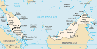
The geography of Malaysia includes both the physical and the human geography of Malaysia, a Southeast Asian country made up of two major landmasses separated by water—Peninsular Malaysia to the west and East Malaysia to the east—and numerous smaller islands that surround those landmasses. Peninsular Malaysia is on the southernmost part of the Malay Peninsula, south of Thailand, north of Singapore and east of the Indonesian island of Sumatra; East Malaysia comprises most of the northern part of Borneo, and shares land borders with Brunei to the north and Indonesian Borneo to the south.

Natuna Regency is an islands regency located in the northernmost part of the Province of Riau Islands, Indonesia. It contains at least 154 islands, of which 127 of them are reported as uninhabited. This archipelago, with a land area of 1,978.49 km2 out of a total area of 264,198.37 km2 area, contains 17 administrative districts (kecamatan).

The Perhentian Islands are islands in Besut District, Terengganu, Malaysia.
Tiga Island is one of a group of small uninhabited volcanic islands in Kimanis Bay off the western coast of Sabah, Malaysia. The islands were formed on 21 September 1897, when an earthquake on Mindanao caused a volcanic eruption near Borneo. The island is 607 hectares in size and has a couple of active mud volcanos at the highest part of the island. Tiga Island is one of the three islands that make up Tiga Island National Park. The Park Headquarters are on the island, comprising an office complex, and accommodation for the park staff and visiting scientists.

Sabah Parks is a conservation-based statutory body established in 1964 with the purpose of conserving the scenic, scientific and historic heritage of the state of Sabah, Malaysia, on the island of Borneo. The organisation is also responsible for the management and promotion of the various protected reserves in Sabah, in particular those designated as national parks. It is also mandated to develop tourism-friendly facilities to accommodate tourist arrivals to these reserves and ensure that the state of the reserves is not compromised. The first choice for inclusion in a park system was Mount Kinabalu. As a result, Kinabalu Park was gazetted in 1964, and today it is designated as a World Heritage Site.

Great Aceh Regency is a regency of the Indonesian province of Aceh. The regency covers an area of 2,903.49 square kilometres and had a population of 351,418 at the 2010 Census, 391,870 at the 2015 census and 405,535 at the 2020 Census; the official estimate as at mid 2023 was 435,298. The Regency is located at the northwest tip of Sumatra island and surrounds the provincial capital of Banda Aceh, many suburbs of which lie within the Regency. It also includes a number of islands off the northern tip of Sumatra, which comprise Pulo Aceh District within the regency. The seat of the Regency government is the town of Jantho.

Sipadan is the only oceanic island in Malaysia, rising 600 metres (2,000 ft) from the seabed. It is located in the Celebes Sea off the east coast of Sabah, Malaysia. It was formed by living corals growing on top of an extinct volcanic cone that took thousands of years to develop. Sipadan is located at the heart of the Indo-Pacific basin, the centre of one of the richest marine habitats in the world. More than 400 species of fish and hundreds of coral species have been classified in this ecosystem. Sipadan Island was at the top of Rodale's Scuba Diving Magazine Gold List for 'The Top Dive Destination in the World'. In fact it shared its top spot with 2 other destinations known for the diversity of their marine life — the Galápagos Islands of Ecuador and Truk in Micronesia. Furthermore, one of the dive operators; Scuba Junkie was voted by the public the "Best Dive Resort in the World 2020" at DiveMagazine's annual Dive Travel Awards.

Redang Island is an island in Kuala Nerus District, Terengganu, Malaysia. It is one of the largest islands off the east coast of Peninsular Malaysia and one of the most beautiful islands in the world. It is famous for its crystal clear waters and white sandy beaches. It is one of nine islands, which form a marine sanctuary park offering snorkeling and diving opportunities for tourists.

Sibu Island is an island group in Mersing District, Johor, Malaysia.

Besar Island, also known as Babi Besar Island is an island in Mersing District, Johor, Malaysia.
Snake Island may refer to:

Gaya Island is a sizeable Malaysian island of 1,465 ha, just 10 minutes off Kota Kinabalu, Sabah and forms part of the Tunku Abdul Rahman National Park. Gaya Island derived its name from the word "Gayo" which means big in both the Kadazandusun and Bajau languages and occupies an area of 15 km2 with an elevation of up to 300 metres. Several ridges rise more than 600 feet, peaking at 1,000 feet, along the backbone of Gaya Island.

Pulau Duyong is a river island in the mouth of Terengganu River in the state of Terengganu, Malaysia.
The Mantanani Islands are a group of three islands off the north-west coast of the state of Sabah, Malaysia, opposite the town of Kota Belud, in northern Borneo. The largest island is Mantanani Besar; the other two are Mantanani Kecil and Lungisan. It is a popular site for recreational diving and is known for its dugongs.
Little Bakkungaan Island is a tiny, flat, tropical island surrounded by the Sulu Sea in the state of Sabah, Malaysia. The island is the largest of the three Malaysian Turtle Islands that together comprise the Turtle Islands National Park. It covers a land area of 8.5 hectares. It is at the very edge of the international treaty limits separating Malaysia from the Republic of the Philippines. Indeed, the island itself is referred to in the international border treaty concluded in 1930 between the United States and the United Kingdom. That treaty sets the international frontier as running in a straight line between Little Bakkungaan Island and Great Bakkungaan Island. Great Bakkungaan Island is one of the Philippine Turtle Islands and less than 2km of water separate the two islands. This makes Little Bakkungaan Island the internationally recognised Malaysian territory that is closest to Philippine territory. The island hosts a turtle hatchery. The island is administered by Sabah Parks. There are several buildings on the island used by park rangers as well as a peer. Much of the island is surrounded by beach.

The Kuala Penyu District is an administrative district in the Malaysian state of Sabah, part of the Interior Division which includes the districts of Beaufort, Keningau, Kuala Penyu, Nabawan, Sipitang, Tambunan and Tenom. The capital of the district is in Kuala Penyu Town.
The Talang Satang National Park is a national park in Kuching Division, Sarawak, Malaysia. It is Sarawak's first marine protected area, and covers the four islands Pulau Talang-Talang Besar, Pulau Talang-Talang Kecil, Pulau Satang Besar and Pulau Satang Kecil and surrounding coral reefs.
