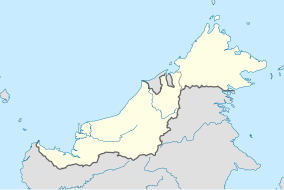
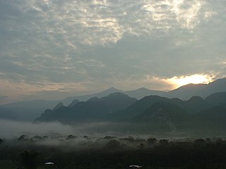
Sarawak is a state of Malaysia. The largest among the 13 states, with an area almost equal to that of Peninsular Malaysia, Sarawak is located in northwest Borneo Island, and is bordered by the Malaysian state of Sabah to the northeast, Kalimantan to the south, and Brunei in the north. The capital city, Kuching, is the largest city in Sarawak, the economic centre of the state, and the seat of the Sarawak state government. Other cities and towns in Sarawak include Miri, Sibu, and Bintulu. As of the 2022, the population of Sarawak was 2.97 million. Sarawak has an equatorial climate with tropical rainforests and abundant animal and plant species. It has several prominent cave systems at Gunung Mulu National Park. Rajang River is the longest river in Malaysia; Bakun Dam, one of the largest dams in Southeast Asia, is located on one of its tributaries, the Balui River. Mount Murud is the highest point in the state. Sarawak is the only state of Malaysia with a Christian majority.

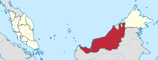
East Malaysia, or the Borneo States, also known as Malaysian Borneo, is the part of Malaysia on and near the island of Borneo, the world's third-largest island. Near the coast of Sabah is a small archipelago called Labuan. East Malaysia lies to the east of Peninsular Malaysia, the part of the country on the Malay Peninsula. The two are separated by the South China Sea.
The geography of Malaysia includes both the physical and the human geography of Malaysia, a Southeast Asian country made up of two major landmasses separated by water—Peninsular Malaysia to the west and East Malaysia to the east—and numerous smaller islands that surround those landmasses. Peninsular Malaysia is on the southernmost part of the Malay Peninsula, south of Thailand, north of Singapore and east of the Indonesian island of Sumatra; East Malaysia comprises most of the northern part of Borneo island, and shares land borders with Brunei to the north and Indonesian Borneo to the south.

The bay cat, also known as the Bornean bay cat, is a small wild cat endemic to the island of Borneo that appears to be relatively rare compared to sympatric wild cats, based on the paucity of historical, as well as recent records. Since 2002, it has been listed as Endangered on the IUCN Red List because it is estimated that fewer than 2,500 mature individuals exist, and that the population declined in the past. The bay cat has been recorded as rare and seems to occur at relatively low density, even in pristine habitat.
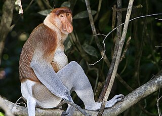
The proboscis monkey or long-nosed monkey is an arboreal Old World monkey with an unusually large nose, a reddish-brown skin color and a long tail. It is endemic to the southeast Asian island of Borneo and is found mostly in mangrove forests and on the coastal areas of the island.

The otter civet is a semiaquatic viverrid native to Thailand, Malaysia, Indonesia and Brunei. It is listed as Endangered because of a serious ongoing population decline, estimated to be more than 50% over the past three generations, inferred from direct habitat destruction, and indirect inferred declines due to pollutants.
The Gunung Mulu National Park is a national park in Miri Division, Sarawak, Malaysia. It is a UNESCO World Heritage Site that encompasses caves and karst formations in a mountainous equatorial rainforest setting. The park is famous for its caves and the expeditions that have been mounted to explore them and their surrounding rainforest, most notably the Royal Geographical Society Expedition of 1977–1978, which saw over 100 scientists in the field for 15 months. This initiated a series of over 20 expeditions now named the Mulu Caves Project.

Betong Division, formed on 26 March 2002, is one of the twelve administrative divisions in Sarawak, Malaysia. Formerly part of Sri Aman Division, Betong is in the Saribas area. It has a total area of 4,180.8 square kilometres, and is the smallest of the administrative divisions of Sarawak.
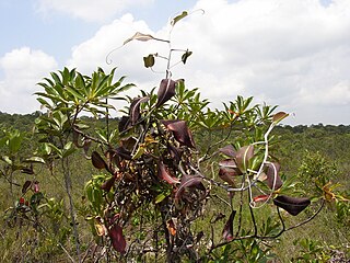
Peat swamp forests are tropical moist forests where waterlogged soil prevents dead leaves and wood from fully decomposing. Over time, this creates a thick layer of acidic peat. Large areas of these forests are being logged at high rates.
Bako National Park is a national park in Kuching District, Kuching Division, Sarawak, Malaysia. Established in 1957, it is the oldest national park in Sarawak. It covers an area of 27.27 square kilometres (10.53 sq mi) at the tip of the Muara Tebas peninsula at the mouth of the Bako and Kuching Rivers. It is approximately 40 kilometres (25 mi) by road from Kuching. Millions of years of erosion of the sandstone have created a coastline of steep cliffs, rocky headlands and stretches of white, sandy bays. Wave erosion at the base of the cliffs has carved many of the rocky headlands into fantastically shaped sea arches and seastacks with colored patterns formed by iron deposition. The most famous of them is shaped like a cobra's head which can be spotted on a boat ride from the headquarters or one of the beaches. Some of these rock formations can be seen on entry to the Teluk Assam Beach, which fronts the park. The park can only be reached by a 20-minute boat ride from the village of Kampung Bako. It is often visited as a day-trip from Kuching, though accommodations are available.

The Borneo peat swamp forests ecoregion, within the tropical and subtropical moist broadleaf forests biome, are on the island of Borneo, which is divided between Brunei, Indonesia and Malaysia.

Storm's stork is a medium-sized stork species that occurs primarily in lowland tropical forests of Indonesia, Malaysia and southern Thailand. It is considered to be the rarest of all storks, and is estimated to number less than 500 wild individuals throughout its geographic range. The population has long been in decline and the primary cause is widely considered to be deforestation of its native habitat.

The wildlife of Malaysia is diverse, with Malaysia being a megadiverse country. Most of the country is covered in rainforest, which hosts a huge diversity of plant and animal species. There are approximately 361 mammal species, 694 bird species, 250 reptile species, and 150 frog species found in Malaysia. Its large marine territory also holds a great diversity of life, with the country's coastal waters comprising part of the Coral Triangle.

The Kuching Wetlands National Park is a national park in Petra Jaya, Kuching District, Kuching Division, Sarawak, Malaysia. It is the remains of the former Sarawak Mangrove Forest Reserve which covered 170 km2.
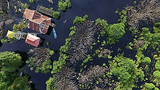
Sabangau National Park is a national park in Central Kalimantan, a province of Indonesia in Kalimantan, the Indonesian part of the island of Borneo established in 2004. Between 1980 and 1995 the site was a massive logging concessions area. After 1995, the park became a site for illegal logging, which resulted in up to 85 percent of the 568,700-hectare total park area being destroyed. By 2012, less than 1 percent of the park's total area has been reforested and at the current rate, it will take several centuries to restore it to its pre-logged state.

The Lake Sentarum National Park is a national park protecting one of the world's most biodiverse lake systems, located in the heart of Borneo Island, Kapuas Hulu Regency, West Kalimantan Province, Indonesia. It lies in the upper Kapuas River tectonic basin some 700 kilometres upstream from the delta. The basin is a vast floodplain, consisting of about 20 seasonal lakes, freshwater swamp forest and peat swamp forest. Local people call it as Lebak lebung (floodplain). The National Park is located in the western part of this basin, where three-quarters of the seasonal lakes occur. Approximately half of the park consists of lakes, while the other half consists of freshwater swamp forest.

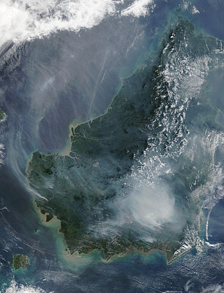
Deforestation in Borneo has taken place on an industrial scale since the 1960s. Borneo, the third largest island in the world, divided between Indonesia, Malaysia and Brunei, was once covered by dense tropical and subtropical rainforests.

The island of Borneo is located on the Sunda Shelf, which is an extensive region in Southeast Asia of immense importance in terms of biodiversity, biogeography and phylogeography of fauna and flora that had attracted Alfred Russel Wallace and other biologists from all over the world.
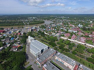
Mukah (muːkəh), historically known as Muka is a coastal town which serves as the capital and the administrative center of the Mukah Division since 1 March 2002.

The Kinabatangan District is an administrative district in the Malaysian state of Sabah, part of the Sandakan Division which includes the districts of Beluran, Kinabatangan, Sandakan, Telupid and Tongod. The capital of the district is in Kinabatangan Town.