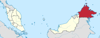
Sabah is a state of Malaysia located in northern Borneo, in the region of East Malaysia. Sabah has land borders with the Malaysian state of Sarawak to the southwest and Indonesia's North Kalimantan province to the south. The Federal Territory of Labuan is an island just off Sabah's west coast. Sabah shares maritime borders with Vietnam to the west and the Philippines to the north and east. Kota Kinabalu is the state capital and the economic centre of the state, and the seat of the Sabah State government. Other major towns in Sabah include Sandakan and Tawau. The 2020 census recorded a population of 3,418,785 in the state. It has an equatorial climate with tropical rainforests, abundant with animal and plant species. The state has long mountain ranges on the west side which forms part of the Crocker Range National Park. Kinabatangan River, the second longest river in Malaysia runs through Sabah. The highest point of Sabah, Mount Kinabalu is also the highest point of Malaysia.

The geography of Malaysia includes both the physical and the human geography of Malaysia, a Southeast Asian country made up of two major landmasses separated by water—Peninsular Malaysia to the west and East Malaysia to the east—and numerous smaller islands that surround those landmasses. Peninsular Malaysia is on the southernmost part of the Malay Peninsula, south of Thailand, north of Singapore and east of the Indonesian island of Sumatra; East Malaysia comprises most of the northern part of Borneo, and shares land borders with Brunei to the north and Indonesian Borneo to the south.

Kota Kinabalu, colloquially referred to as KK, is the state capital of Sabah, Malaysia. It is also the capital of the Kota Kinabalu District as well as the West Coast Division of Sabah. The city is located on the northwest coast of Borneo facing the South China Sea. The Tunku Abdul Rahman National Park lies to its west and Mount Kinabalu, which gave the city its name, is located to its east. Kota Kinabalu has a population of 452,058 according to the 2010 census; when the adjacent Penampang and Tuaran districts are included, the metro area has a combined population of 628,725. The 2020 Census revealed an increase in the municipal population to 500,421, while the wider area including the Penampang and Putatan districts had a population of 731,406.
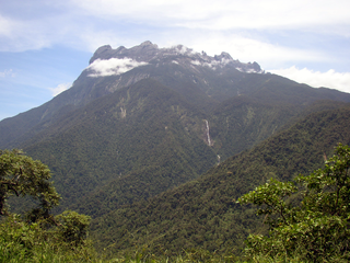
Kinabalu Park, established as one of the first national parks of Malaysia in 1964, is Malaysia's first World Heritage Site designated by UNESCO in December 2000 for its "outstanding universal values" and the role as one of the most important biological sites in the world with more than 4,500 species of flora and fauna, including 326 bird and around 100 mammal species, and over 110 land snail species.

The Tunku Abdul Rahman National Park comprises a group of 5 islands located between 3 and 8 km off Kota Kinabalu in Sabah, Malaysia. The park is spread over 4,929 hectares, two-thirds of which cover the sea. Before the Ice age, it formed part of the Crocker Range mass of sandstone and sedimentary rock on the mainland. However, about one million years ago, the melting ice brought about changes in the sea level and parts of the mainland were cut off by the sea to form the islands of Gaya, Sapi, Manukan, Mamutik and Sulug. Evidence of this can be seen from the exposed sandstone of the coastline forming the cliffs, caves, honeycombs and deep crevices. The park was named after Tunku Abdul Rahman, Malaysia's first Prime Minister.
Turtle Islands Park is located within the Turtle Islands, which lie in the Sulu Sea some 3 kilometres north of Sandakan in Sabah, Malaysia. It consists of 3 islands - Selingaan, Little Bakkungan and Gulisaan, including the surrounding coral reefs and ocean. The Park is noted for its green turtles and hawksbill turtles which lay their eggs on the beaches of the islands. The Park covers an area of 17.4 km². The name Turtle Islands, however, refers to 10 islands, 3 of which are part of Turtle Islands Park of Malaysia, and 7 which belong to the Turtle Islands Wildlife Sanctuary of Tawi-Tawi province, Philippines.
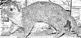
The Bornean ferret badger, also known as Everett's ferret badger or the Kinabalu ferret badger, is a small, nocturnal and omnivorous mammal that is endemic to the island of Borneo. It is a member of the family Mustelidae and is one of six species of the genus Melogale. It is listed as endangered on the IUCN Red List of Threatened Species due to its small distribution range, which includes Kinabalu National Park and Crocker Range National Park.

The Department of Wildlife and National Parks of Peninsular Malaysia, abbreviated PERHILITAN, is a governmental organisation that is responsible for the protection, management and preservation of wildlife and national parks in Peninsular Malaysia.

The Crocker Mountains form a range that separates the West Coast and Interior divisions of Sabah, Malaysia. At an average height of 1,800 metres (5,906 ft), it is the highest mountain range in the state. It is named after a 19th century British administrator of North Borneo, William Maunder Crocker.

The Rafflesia Forest Reserve is a Virgin Jungle Reserve (VJR) that covers an area of 356 hectares in Tambunan District of Sabah, Malaysia. The reserve was first established in 1967 as part of the Crocker Range Forest Reserve. In 1984, it was made a separate reserve by the Sabah Forestry Department to protect the area's Rafflesia flowers.
Mount Trusmadi or Trus Madi is a mountain located at the Interior Division of Sabah, Malaysia. It is considered as the second highest mountain in both Sabah and Malaysia at 2,642 metres (8,668 ft), after Mount Kinabalu with Trusmadi offering a tougher climbing challenge than the latter.
Malaysian Wildlife Law consists of the regulation, protection, conservation and management of wildlife in Malaysia. The Constitution of Malaysia empowers those at the federal and the states level to make laws regarding wildlife resources. As such, eleven states in peninsular are managed under an act while Sabah enacted an enactment and Sarawak an ordinance.
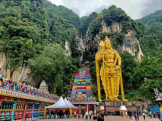
Tourism in Malaysia is a major industry and contributor to the Malaysian economy. Malaysia was once ranked 9th in the world for tourist arrivals. In 2017, the Travel and Tourism Competitiveness Report ranked Malaysia 26 out of 141 countries using its Travel & Tourism Competitiveness Index (TTCI) which measures the various components and policies of a country that are in place to allow for the sustainable development of its travel and tourism sectors.

The Selangor State Park is a park located in Gombak District, Selangor, Malaysia. The 914.41 square kilometre park was gazetted by the state on January 25, 2007. Upon its establishment, it became the second largest park in Peninsular Malaysia with the largest being the Taman Negara.

Muhammad Fuad Stephens, was a Malaysian politician who served as the 1st and 5th Chief Minister of Sabah from September 1963 to December 1964 and again briefly from April 1976 to his death in June 1976, 3rd Yang di-Pertua Negara of Sabah from September 1973 to July 1975, 6th High Commissioner of Malaysia to Australia from 1968 to 1973. In addition, he also served as the 1st Huguan Siou or Paramount Leader of the Kadazandusun community. He played a role in bringing Sabah into the Federation of Malaysia in 1963. While he was initially against the idea of Sabah joining in the Federation, given British concerns about the stability of the region and their move to relinquish all their colonies in the post WWII era, he was gradually convinced to work towards it. He held the chief minister's post from 16 September 1963 until 31 December 1964 when he was forced to resign; and again in 1976 for 54 days from 15 April.

The National Parks Act 1980 is a Malaysian federal law that governs the creation and the maintenance national parks in Malaysia. It was created in 1980 during the controversy surrounding the protection of Endau Rompin forest complex. The act provides for the states to establish national parks to be administered by Department of Wildlife and National Parks under the federal government.

The environment of Malaysia is the biotas and geologies that constitute the natural environment of Malaysia. Malaysia's ecology is megadiverse, with a biodiverse range of flora and fauna found in various ecoregions throughout the country. Tropical rainforests encompass between 59% and 70% of Malaysia's total land area, of which 11.6% is pristine. Malaysia has the world's fifth largest mangrove area, which totals over a half a million hectares.

The Sugut River is a river located in the northeastern part of Sabah, Malaysia, between the tripoint of the West Coast, Sandakan as well as a portion of the Kudat division. It has a total length of 178 km from its headwaters in the mountains of northwest Sabah to its outlet at the Sulu Sea, northeastern of Beluran town. Its source is originated from the mountains in the eastern slopes of Mount Kinabalu National Park in Ranau District, which part of the Mount Kinabalu system.

Tenompok Forest Reserve is a protected forest reserve in Ranau District of West Coast Division, Sabah, Malaysia. It was designated as a Class 1 Forest Reserve by the Sabah Forestry Department in 1984. Its area is 1,984 hectares (19.84 km2). A former reserve, the Kampung Bundu Tuhan Native Residence Reserve, occupied what is now the eastern portion of Tenompok. The reserve is mountainous, reaching 1,660 metres (5,450 ft) above sea level. Vegetation consists of lower montane forest and montane kerangas forest. Both share a similar species composition, although trees in montane keranga forests are smaller. The reserve's Tomis River is a tributary of the Tuaran River. The area of the reserve has never received significant logging, aside from small amount near what are now its borders. This small logging is thought to be carried out by nearby villages for local use. There is also some agricultural encroachment. The reserve lies between Kinabalu Park and Crocker Range National Park. One farmer has a house within the reserve. There are several settlements around the reserve, along with agricultural land.
