Sabah Parks is a conservation-based statutory body established in 1964 with the purpose of conserving the scenic, scientific and historic heritage of the state of Sabah, Malaysia, on the island of Borneo. The organisation is also responsible for the management and promotion of the various protected reserves in Sabah, in particular those designated as national parks. It is also mandated to develop tourism-friendly facilities to accommodate tourist arrivals to these reserves and ensure that the state of the reserves is not compromised. The first choice for inclusion in a park system was Mount Kinabalu. As a result, Kinabalu Park was gazetted in 1964, and today it is designated as a World Heritage Site.

Sandakan formerly known at various times as Elopura, is the capital of the Sandakan District in Sabah, Malaysia. It is the second largest city in Sabah after Kota Kinabalu. It is located on the Sandakan Peninsula and east coast of the state in the administrative centre of Sandakan Division and was the former capital of British North Borneo. In 2010, the city had an estimated population of 157,330 while the overall municipal area had a total population of 396,290. The population of the municipal area had increased to 439,050 by the 2020 Census.
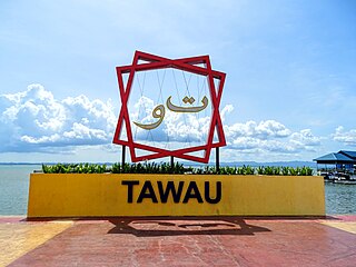
Tawau, formerly known as Tawao, is the capital of the Tawau District in Sabah, Malaysia. It is the third-largest city in Sabah, after Kota Kinabalu and Sandakan. It is located on the Semporna Peninsula in the southeast coast of the state in the administrative centre of Tawau Division, which is bordered by the Sulu Sea to the east, the Celebes Sea to the south at Cowie Bay and shares a border with North Kalimantan, Indonesia. The town had an estimated population as of 2010, of 113,809, while the whole municipality area had a population of 397,673. The municipal area had a population of 372,615 at the 2020 Census.
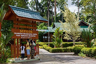
Sepilok Orangutan Rehabilitation Centre is located about 25 kilometres west of Sandakan in the state of Sabah, Malaysia.

Keningau is the capital of the Keningau District in the Interior Division of Sabah, Malaysia. It is the fifth-largest town in Sabah, as well one of the oldest. Keningau is between Tambunan and Tenom. The town had an estimated population of 173,130.
Crocker Range National Park was established in 1984, although the area had previously been under protection as a forest reserve. It covers the north-south Crocker Range, of 1200-1800 metre mountains in Sabah, Malaysia. In the vicinity of park headquarters, there is a resort that provides accommodation and food services. Other visitors facilities such as an exhibition centre, insectarium, fernarium, observation tower and trekking trail can also be found.
Batang Ai National Park is a national park located in Sri Aman Division, Sarawak, Malaysia. It is located in Lubok Antu, some 250 kilometers east of Kuching. The park covers an area of 24 square kilometres (9.3 sq mi) of extensive tropical rainforest with a number or rare and protected animals surrounding the 24 square kilometer artificial lake created by the Batang Ai hydroelectric reservoir. The park was proclaimed in 1991, and has become increasingly popular with locals and tourists despite the lack of facilities.

The Gombak District is an administrative district located in the state of Selangor, Malaysia. The district was created on February 1, 1974, the same day when Kuala Lumpur was declared a Federal Territory. Until 1997, Rawang was the district capital; the capital has been moved to Bandar Baru Selayang. Gombak borders Kuala Lumpur to the southeast and the Genting Highlands to the east. Both Gombak and Kuala Lumpur, along with some other districts in Selangor, are situated within the Klang Valley. Other localities that are situated in Gombak district include Batu Arang, Kuang, Rawang, Kundang, Gombak Town, Selayang, Batu Caves and Hulu Kelang.
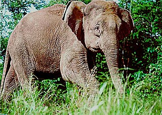
The Borneo elephant, also called the Bornean elephant or the Borneo pygmy elephant, is a subspecies of Asian elephant (Elephas maximus) that inhabits northeastern Borneo, in Indonesia and Malaysia. Its origin remains the subject of debate. A definitive subspecific classification as Elephas maximus borneensis awaits a detailed range-wide morphometric and genetic study. Since 1986, the Asian elephant has been listed as Endangered on the IUCN Red List as the population has declined by at least 50% over the last three generations, estimated to be 60–75 years. It is pre-eminently threatened by loss, degradation and fragmentation of habitat.
Shorea confusa is a species of plant in the family Dipterocarpaceae. The species name is derived from Latin and refers to the fact that this species is often misidentified as Shorea virescens. S. confusa is endemic to Borneo. It is an emergent tree, up to 50 metres (160 ft) tall, in mixed dipterocarp forest on clay-rich soils. It is a light hardwood sold under the trade names of white meranti. S. confusa is found in at least three protected areas, but is threatened elsewhere due to habitat loss.
Shorea atrinervosa is a species of plant in the family Dipterocarpaceae. The species name is derived from Latin and refers to leaf venation which is black in herbarium specimens.
The Semporna Peninsula is a peninsula in Tawau Division, Sabah, Malaysia. It consists of coastal areas and numerous isolated hills and mountains rising to over 305 metres (1,001 ft). The Peninsula is also considered as a volcanic arc of the region with several volcanoes active during the Holocene period is located on the area.
Gunung Rara Forest Reserve is a rainforest area in Tawau Division, Sabah, Malaysia. Borneo elephants probably were killed in a concession area of Yayasan Sabah in the reserve. The concession was originally intended to be managed into perpetuity for the benefit of all Sabahans but was instead largely decimated by overharvesting. The reserve sits between Danum Valley and Maliau Basin Conservation areas. There are palm oil plantations in the reserve. The rainforests in Sabah are endangered by palm oil plantations.

The Bornean Sun Bear Conservation Centre is a wildlife conservation and research centre for improving animal welfare and rehabilitation of the Malayan sun bear. It also aims to raise public awareness about the plight of the sun bears and to raise conservation awareness about this species.

Agop Batu Tulug Caves is an archaeological site in the Malaysian state of Sabah and refers to a group of several caves in a steep limestone cliffs in the Kinabatangan district.

The Sugut River is a river in Sandakan Division, northeastern Sabah of Malaysia. It has a total length of 178 km (111 mi) from its headwaters in the mountains of northwest Sabah to its outlet at the Sulu Sea, northeastern of Beluran town. Its source is originated from the mountains in the eastern slopes of Mount Kinabalu National Park in Ranau District, which part of the Mount Kinabalu system.
Ulu Telupid Forest Reserve is a protected forest reserve in Tongod District of Sandakan Division, Sabah, Malaysia. First established in 1972, it was designated as a Class 1 Protection Forest by the Sabah Forestry Department in 1984. Its area is 6,460 hectares (64.6 km2), down from its former size of 7,508 hectares (75.08 km2). Prior to being established as a forest reserve, the area was used for logging and palm oil plantations. The reserve is mostly mountainous, consisting mainly of mixed dipterocarp forest. The land surrounding the reserve includes a town, oil palm plantations, rubber plantations, and rice paddies. It is threatened by fires and illegal logging. In some areas agricultural activities have encroached into the protected area. Since 2000 there has been a net loss of just under 2% of the reserve's forested area. There is a small level of ecotourism activity in the reserve, consisting of guided tours from a nearby village, which provides livelihood alternatives to logging and poaching.
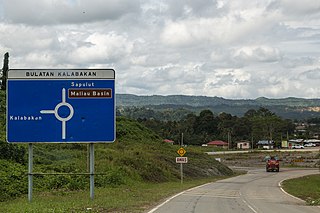
Kalabakan is a district in the Malaysian state of Sabah, located approximately 235 kilometres (146 mi) southeast of the state capital of Kota Kinabalu. It recorded a population of 48,195 people in the 2020 Malaysian census. Its capital is the town of Kalabakan.
Mount Pock Forest Reserve is a protected forest reserve in Semporna District of Tawau Division, Sabah, Malaysia. It was designated as a Class 1 Protection Forest by the Sabah Forestry Department in 1984. Its area is 7,804.8 hectares (78.048 km2). The reserve consists of steeply sloping terrain. The forest on lower slopes has been impacted by logging and conversion of land for agriculture. Oil palm plantations surround the reserve. The size of the reserve has decreased since its initial gazetting. In 2012, 1,388 ha (13.88 km2) of the Mount Pock Reserve was reclassified as state land as this area, along with parts of other reserves, have been home to indigenous communities.
