Song | |
---|---|
Town and district capital | |
Chinese transcription(s) | |
• Simplified | 桑 |
Coordinates: 2°01′N112°33′E / 2.017°N 112.550°E | |
Country | Malaysia |
State | Sarawak |
Division | Kapit |
District | Song |
Population | |
• Estimate (2010) | 20,046 (District) |
Time zone | UTC+8 (MST) |
• Summer (DST) | UTC+8 (Not observed) |
Postal code | 96850 |
Website | www |
Song (Malay : Pekan Song) is a town, and the capital of the Song District (3,935.2 square kilometers) in Kapit Division, Sarawak, Malaysia. The district population was 20,046 according to the 2010 census. [1] Song is situated by the banks of the Katibas River, a tributary of the Rajang River. It is an important stopover for river traffic going up the Rajang River.
The district was originally named by the Kayan people as long which means river stream. After the Kayan people was defeated by the Iban people, the Ibans decided to rename the place after an Iban warrior named Song who led them to victory against the Kayans. Another version of the origin of the name Song came from the legend of the Melanau people. There was once a Melanau widow named Song who came from Nangka village, Sibu. She went to the present day Song river mouth for agriculture. Her relatives would frequently visit her. When they ask her which place she would like to go, she would said "to Rumah Song " (her own home). Thus the area is called Song since then. [2]
The Kayan people were the first group of settlers inhabited the Song District. At that time, the Kayans were the nomadic people. At the same time, the Iban people migrated from the present day Kalimantan, Indonesia and settled near the banks of the Katibas River (located in the Song District) in order to find land for farming. However, conflict between the Kayan and the Iban people soon grew into a war and the Iban people won. Accepting defeat, the Kayan people then migrated to Belaga District. [2]
The Malays and the Chinese first arrived in Song District in the 1800s. They built wooden shophouses with nipah roofs along the river banks and opened floating shops on the river. Initially, the barter system was used, but when Song was acquired by the Kingdom of Sarawak, a monetary system was introduced. The first three Malays to arrive in Song were Mr Haji Tahir, Haji Omar, and Haji Dollah. In 1870, the Brooke government built a fort at Nanga Song (mouth of Song river). The fort also functioned as the first administrative centre for Song and was intended to inhibit Iban uprisings at Katibas river. The Iban people opposed the introduction of the assessment tax by the Brooke government. Such uprisings lasted until the 1900s. In 1873, Sibu Division was established. Kapit and Song sub-district were included in the division at that time. In 1937, there were 10 Malay houses in Song. The Malay traders at Song were known as Abang (meaning "nobleman"). In the 1820s, they traded with the Ibans in Song in exchange for jungle produce. One of the well-known traders was Haji Ahmed bin Haji Omar. The Malays would sell the jungle produce in Sibau town (present-day Sibu) for a profit. Ships like "Ang Bee" from Singapore and "Kampar" from the Malay Peninsula would anchor in Sibu to carry the jungle produce back to their respective destinations for sale. In exchange, these ships brought daily necessities such as salt, sugar, salted fish, plates, bowls, pottery and clothes to trade with the natives. Meanwhile, the Iban people worked as farmers, rubber tappers and jungle produce collectors. The Ibans then sold their products at the Song bazaar in exchange for daily necessities. [2]
During the Japanese occupation, both Allied and Japanese bombings destroyed many of the buildings in the village. Many residents fled Song due to the war. The town became chaotic during the war and its people endured harsh Japanese administration. During this time, the Chinese started to build the first primary school in Song. After the war, the British colonial government gave Sarawak dollars to residents of Song to rebuild their homes. In 1948, the fort at Nanga Song was moved to Nanga Katibas (mouth of Katibas river). Thus, the administrative centre at Song river was effectively moved to Katibas river. The Chinese also restarted their businesses in Song after the war. [2]
During the British colonial era, the Sarawak Natives Affairs Department was established in 1955. Michael Sardin became the first native officer. During the Indonesia–Malaysia confrontation, Song sub-district office was the operational centre to repel Indonesian military crossings of the Sarawak-Kalimantan border. After the formation of Malaysia in 1963, William Linang became the first Sarawak Administrative Officer (SAO) in Song. On 2 April 1973, Kapit was upgraded to division. At the same time, Song sub-district was upgraded into a district. In 1977, the administrative centre of Song was moved from the fort at Katibas river to the town centre. [2]
Song District Office governs an area of 38,934 km2. [3]
Song is one of three districts located within Kapit Division. The other two districts are: Kapit District and Belaga District. Rajang River is the main river crossing the Song District. Other rivers that cross the district are: Katibas river, Song river, Iran river, Manap river, Lajan river and Lijau river. These rivers are the main transportation routes for Song residents. 90% of the Song district is covered with uneven highlands, [3]
In 2010, Song District had a population of 20,046. [1] The Iban people accounted for 80% of the district population, followed by Chinese, Melanau people, Malay and Bidayuh. [3]
This section needs expansion. You can help by adding to it. (September 2018) |
There are hourly express boat services connecting Song, Sibu, Kanowit, Kapit and Belaga. It is approximately 2 hours journey from Sibu and an hour from Kapit. The express boats services are provided frequently at Song Wharf Terminal.
However, a plan to build roads connecting Song to Kapit and Song to Kanowit was promised by the Federal Government and was announced by the Prime Minister of Malaysia during his visit to the town on 15 April 2011.
The bus express of Sibu-Song-Kapit is available since 2022.
Operating Route | Operator | Remark |
---|---|---|
Sibu-Kapit | Kapit Bus Express, BusAsia, Lanang Bus | |
Secondary Schools:
Primary Schools :
This section needs expansion. You can help by adding to it. (September 2018) |
Sibu is a landlocked city located in the central region of Sarawak, Malaysia. It serves as the capital of Sibu District within Sibu Division and is situated on the island of Borneo. Covering an area of 129.5 square kilometres (50.0 sq mi), the city is positioned at the confluence of the Rajang and Igan Rivers, approximately 60 kilometres from the South China Sea and 191.5 kilometres (119 mi) north-east of the state capital, Kuching.
Simanggang is a town and the capital of Sri Aman District and Sri Aman Division in Sarawak, east Malaysia. Located on the Lupar River, it is 193 kilometres (120 mi), a three-hour drive, from Kuching, the capital of Sarawak. It is a trade center for the timber, oil palm, rubber, and pepper of its mostly agricultural district.
The Rajang River is a river in Sarawak, northwest Borneo, Malaysia. The river originates in the Iran Mountains, flows through Kapit, and then towards the South China Sea. At approximately 565 km long (351 mi), the river is the seventh-longest in Borneo and the longest in Malaysia.
Kapit Division, formed on 2 April 1973, is one of the twelve administrative divisions in Sarawak, Malaysia. It has a total area of 38,934 square kilometres, and is the largest of the administrative divisions of Sarawak.
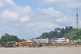
Kapit is a town and the capital of Kapit District in Kapit Division, Sarawak, Malaysia on the south bank of the Rajang River. The district comprises 15,595.6 square kilometres and as of 2020, it has a population of 65,800.
Sibu Division is one of the twelve administrative divisions of Sarawak, Malaysia. It has a total area of 8,278.3 square kilometres, and is the third largest division after Kapit Division and Miri Division.
Kanowit is a town and the capital of Kanowit District, Sibu Division, Sarawak, Malaysia, comprising 2,253.5 square kilometres. As of 2010, Kanowit's population is 28,985. It is built on the mouth of Kanowit River at the bank of Rajang River, approximately 174 kilometers from the coast of South China Sea. It takes 45 minutes to reach the town by land transport and an hour by boat from Sibu. The main ethnic groups are Iban, Chinese, Malay, and Melanau.
Betong is a town in Betong Division in Sarawak, Malaysia, lying in the Saribas area. It was formerly under the Sri Aman district. Betong is located between three main rivers, Batang Lupar, Batang Saribas and Batang Kelaka, and covers an area of 4,180 km2.
Julau is a town, and the capital of the Julau District in Sarikei Division, Sarawak, Malaysia. The district population is 15, 333. The population is dominated by Iban as well as Chinese especially the Fuzhou.
Lubok Antu District is a district in the Sri Aman Division of the state of Sarawak, Malaysia. It borders on Indonesia and a Malaysian border crossing checkpoint is located here. The checkpoint on the Indonesian side is called the Nanga Badau Border Crossing Checkpoint located in the village of Badau, West Kalimantan. The seat of Lubok Antu District is the town of Lubok Antu.
Dalat is the administrative town of the Dalat district in Mukah Division, Sarawak, Malaysia. It is situated by the Oya River.
Melanau or A-Likou is an ethnic group indigenous to Sarawak, Malaysia. They are among the earliest settlers of Sarawak. They speak in the Melanau language, which is a part of the North Bornean branch of Malayo-Polynesian languages.
Pakan is a small town in Pakan District, Sarikei Division, Sarawak, Malaysia. The district population estimates was 17,600.
Sebauh is a district of Bintulu Division, Sarawak, Malaysia. It shares a boundary with Miri, Baram, Kapit Division, Belaga and Tatau. It has a total area of roughly 5,262.90 square kilometres. Sebauh town is a main administrative and economy centre of Sebauh district.
Selangau, Sarawak, is a small town located by the Pan Borneo Highway. It is also located by Batang Mukah, a river which flows to the South China Sea. It is located approximately 74 km (46 mi) from Sibu city, 84 km (52 mi) from Mukah town and 134 km (83 mi) from Bintulu town. Selangau town is the administrative centre for the Selangau District.
The Fort Sylvia is a historical fort in Kapit, Sarawak, Malaysia. Built in 1880, it was renamed after Rani Sylvia Brooke, wife of Rajah Charles Vyner Brooke, in 1925. During the 1960s, the fort housed the District Office and the District Court House, and later the Resident's Office when Kapit Division was formed in 1973.
Sarawak's population is very diverse, comprising many races and ethnic groups. Sarawak has more than 40 sub-ethnic groups, each with its own distinct language, culture and lifestyle. This makes Sarawak demography very distinct and unique compared to its Peninsular counterpart. However, it largely mirrors to other territories in Borneo - Sabah, Brunei and Kalimantan.
The Dalat District is located in Mukah Division, Sarawak, Malaysia. It is situated by the Oya river. The district covers areas from Kg. Penat to Oya, and from Muara Sg. Kut to Ulu Baoh. The district has an area of 905.29 km2, while the Oya sub-district has an area of 147.47 km2.
Tebedu District is a district in the state of Sarawak, Malaysia. It is a part of Serian Division that consists of Serian, Siburan, and Tebedu districts. Before this, Tebedu District was a sub-district under Serian District which was then fully upgraded to a district in its own right. The majority of the population of this district is from the Bidayuh ethnic group.