Sungai Tujoh is a Bruneian territory lies along the Malaysian-Bruneian border. Each country constructed their own immigration complex within their respective territories. The Malaysian side constructed Immigration, Customs, Quarantine and Security (ICQS) Complex at Kuala Baram near the border[2] while Bruneian authorities set up a custom, excise and immigration post staffed by immigration officers.[3]Royal Brunei Police Force (RBPF) control post is also set up to monitor the Brunei-Malaysia border.[4]
Etymology
The name of the area is derived from two Bruneian Malay words - Sungai,[5] which means river or stream, and Tujoh[6] or the number seven. Literally, Sungai Tujoh is translated as the Seventh River or Seventh Stream in English.
Although it is sometimes referred to as Kampong Sungai Tujoh, there is no permanent settlement in the area.[citation needed]
Location
Sungai Tujoh is located at the westernmost point in Brunei, in the Belait district,[1] It borders with Kuala Baram, Miri District, Sarawak.[7][8] The area is bounded by the border with Malaysia on the west and south side, the South China Sea to the north and the Sungai Enam area to the east.
The Sungai Tujoh area has been long claimed by the sultan of Brunei to constitute a part of the sultanate. It was divided in 1882, when the then sultan ceded the basin of the Baram to the White Rajah of Sarawak, an area of some 10,000 square miles (30,000km2), on condition of a perpetual annual payment of 6000dollars.[9]
The border was delineated in 1958 by the United Kingdom[10] who then had sovereignty over the colony of Sarawak and was responsible for the external relations of the protectorate of Brunei. An immigration post was built in the 1960s to control the movement of goods and people between Miri and points west in Sarawak with Brunei.[citation needed] In 2003, ASEAN Bridge was constructed across the Baram River, connecting the city of Miri to Malaysian ICQS complex in Sungai Tujoh. Initially, it was a toll bridge. The bridge become toll-free in 2015.[11]
The frequent traveller's card (FTC) was first implemented in 2005 at Sungai Tujoh. This enables residents from both countries to use their Mykad/Smart IC as a legal document for travel between the two countries instead of an international passport. As at December 2013 the FTC is no longer accepted. [12]
Transport
The main roads linking the ferry crossing towards the Malaysian border (11kilometers)[13] and towards Rasau bridge are surfaced.
There is a scheduled bus service that runs from Kuala Belait and terminates at the immigration post at Sungai Tujoh.[14] Passengers have to clear customs and immigration on foot and take a separate bus to Miri.
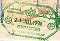
Gallery
Brunei exit stamp from the Sg Tujoh border crossing
Belait District, or simply Belait, is the largest as well as the westernmost district in Brunei. It has an area of 2,727 square kilometres (1,053 sq mi) and the population of 69,062 as of 2016. The administrative town is Kuala Belait, located at the mouth of the Belait River. The district is commonly associated with the oil and gas industry of the country, mainly concentrated near the town of Seria.
Limbang is a border town and the capital of Limbang District in the Limbang Division of northern Sarawak, East Malaysia, on the island of Borneo. This district area is 3,978.10 square kilometres, and population was 56,900. It is located on the banks of the Limbang River, between the two halves of Brunei.
Lawas is a small town and the capital of Lawas District, Limbang Division, Sarawak, Malaysia. This district area is 3,811.90 square kilometres, and population was 46,200. It is 1,200 km from the state capital, Kuching and 200 km from the capital city of Sabah, Kota Kinabalu.
Seria is a town in Belait District, Brunei, about 65 kilometres (40 mi) west from the country's capital Bandar Seri Begawan. The total population was 3,625 in 2016. It was where oil was first struck in Brunei in 1929 and has since become a centre for the country's oil and gas industry. The town's bazaar, officially opened on 19th September 1954, has few retail establishments, fresh food markets, supermarkets, banking services, tourist information centers, and a range of restaurants, including Malay, Chinese, Indian, Indonesian and Italian ones as well as outdoor dining in somewhat rustic settings. For processing documentation related to owning a car and hiring domestic helpers (amahs), government offices are located in Kuala Belait.
Malaysian Federal Roads System, is the main national road network in Malaysia. All Federal Roads in Malaysia are under the purview of the Ministry of Works (MOW). According to the Ministerial Functions Act 1969, the MOW is responsible to plan, build and maintain all Federal Roads gazetted under the Federal Roads Act 1959. However, most of the Federal roads' projects were built and maintained by the Malaysian Public Works Department (JKR), which is also one of the implementing agencies under the MOW.
The Baram River is a river in Sarawak on the island of Borneo. The river originates in the Kelabit Highlands, a watershed demarcated by the Iran Mountains of East Kalimantan, which form a natural border with Sarawak. The river flows westwards through tropical rainforest to the South China Sea. The Baram River terminates in a delta, which is subdivided into two units: East Barma Delta of Middle-Late Miocene age and West Baram Delta of Late Miocene-Quaternary age. The western unit is composed of mudstones enriched in organic components which constitute substantial oil and gas reserves.
Limbang Division is one of the twelve administrative divisions of Sarawak, Malaysia. It has a total area of 7,788.50 square kilometres, and is the fourth largest division after Kapit Division, Miri Division and Bintulu Division. Limbang Division consists of two districts which are Limbang District and Lawas District, which in turn are divided as sub-districts in Limbang and two sub-districts in Lawas. Long Semadoh and Ba’kelalan are rural settlements in the southern part of Lawas district. Two major towns in Limbang are Limbang and Lawas. There are also few smaller towns such as Sundar, Trusan, Merapok and Tedungan.
Tebedu is a border town in the Serian division of southwestern Sarawak, Malaysia, on the Indonesia-Malaysia border. It lies approximately 63.2 kilometres (39 mi) south of the state capital Kuching. It is the administrative seat for Tebedu District.
Kampong Sungai Teraban is a village in Belait District, Brunei, near the district's principal town Kuala Belait. It has an area of 22 square kilometres (8.5 sq mi); the population was 1,082 in 2016. It is one of the administrative villages within Mukim Kuala Belait.
Mukim Kuala Belait is a mukim in Belait District, Brunei. The population was 31,308 in 2016. The mukim encompasses Kuala Belait, the administrative town of the district.
Rasau is an area in Brunei. The area contains one of the two oil fields of Brunei, the Rasau Field, and a small village, Kampong Rasau, which has a population of 103.
Kampong Sungai Duhon is a village that is located within the town of Kuala Belait in Mukim Kuala Belait, Belait District of Brunei. The postcode is KA3131.
Mukim Labi is a mukim in the interior of Belait District, Brunei. It has an area of 361.8 square kilometres (139.7 sq mi); the population was 1,216 in 2016.
Miri–Baram Highway, Federal Route 1-82, also known as Jalan Kuala Baram-Sungai Tujuh, is a major highway in Miri Division, Sarawak, Malaysia. This highway is part of the Pan Borneo Highway AH 150.
The Batang Baram Bridge or ASEAN Bridge is the longest bridge in Miri Division, Sarawak, Malaysia. The bridge is located along Miri-Baram Highway (Federal Route FT 1-82). The ASEAN Bridge is located approximately 2 km upstream of the New Miri Port Complex. The bridge and access road directly link Sarawak with Brunei across the Batang Baram via the existing Immigration Checkpoint at Sungai Tujuh.
The Brunei–Malaysia border divides the territory of Brunei and Malaysia on the island of Borneo. It consists of a 266 km (165 mi) land border and substantial lengths of maritime borders stretching from the coastline of the two countries to the edge of the continental shelf in the South China Sea.
The Pandaruan River is a river that forms an international border on the island of Borneo, between Temburong, Brunei and Limbang, Malaysia. It is located at the river mouth of the Brunei Bay.
The Limbang District is one of the two districts of Limbang Division, Malaysia. It has a total area of 3,978.10 square kilometres. The major town is Limbang. It has one sub-district, which is Nanga Medamit Sub-District. It borders Brunei Darussalam to the west and east, Lawas District to the southeast and Miri District at the south and southwest. Due to being squeezed in between Brunei at its north and coastal areas, Limbang is accessible by road only by going through immigration posts.
High intensity rainfall since 17 January 2015 caused major flooding across several parts of Sarawak and Sabah. Around 13,878 people had been evacuated with one teenage girl became the only casualty.
Tebedu District is a district in the state of Sarawak, Malaysia. It is a part of Serian Division that consists of Serian, Siburan, and Tebedu districts. Before this, Tebedu District was a sub-district under Serian District which was then fully upgraded to a district in its own right. The majority of the population of this district is from the Bidayuh ethnic group.
This page is based on this Wikipedia article Text is available under the CC BY-SA 4.0 license; additional terms may apply. Images, videos and audio are available under their respective licenses.