Mukim Kuala Belait

Last updated
Mukim Kuala Belait
Mukim Kuala Belait sign.jpg
Mukim Kuala Belait sign
Belait mukims.png
Kuala Belait is in red.
Coordinates: 4°35′N114°11′E / 4.583°N 114.183°E / 4.583; 114.183 Coordinates: 4°35′N114°11′E / 4.583°N 114.183°E / 4.583; 114.183
Country Brunei
District Belait
Government
   Penghulu Pungut Ali [1]
Population
 (2016) [2]
  Total31,308
Time zone UTC+8 (BNT)
Postcode
KAxx31

Mukim Kuala Belait is a mukim in Belait District, Brunei. [3] The population was 31,308 in 2016. [2] The mukim encompasses Kuala Belait, the administrative town of the district.

Contents

Geography

The mukim is the located in the westernmost part of the district as well as the country. It borders the South China Sea to the north, Mukim Seria to the east, Mukim Kuala Balai to the south-east and the Malaysian state of Sarawak to the south and west.[ citation needed ]

The primary settlements encompassed by the mukim include Kuala Belait town, Kampong Pandan, Kampong Sungai Teraban and Mumong.

Demographics

As of 2016 census, [2] the population was 31,308 with

Villages

As of 2016, Mukim Kuala Belait comprised the following census villages: [2]

VillagePopulation
(2016)
Kampong Mumong Kampong Mumong 'A'5,710
Kampong Mumong 'B'4,030
Kampong Pandan Kampong Pandan 'A'5,493
Kampong Pandan 'B'4,229
Kampong Pandan 'C'6,505
Kampong Sungai Teraban 1,082
Kuala Belait 4,259
Kampong Sungai Duhon [4]
Kampong Melayu Asli [5]
Kampong China
Kampong Sungai Melilit/Rasau
Total31,308

Infrastructures

Public housing

There are two public housing estates in the mukim, namely RPN Kampong Pandan and STKRJ Mumong.

Other locations

Other locations within the mukim include:

Related Research Articles

<span class="mw-page-title-main">Belait District</span> District of Brunei

Belait District, or simply Belait, is the largest as well as the westernmost district in Brunei. It has an area of 2,727 square kilometres (1,053 sq mi) and the population of 69,062 as of 2016. The administrative town is Kuala Belait, located at the mouth of the Belait River. The district is commonly associated with the oil and gas industry of the country, mainly concentrated near the town of Seria.

<span class="mw-page-title-main">Kuala Belait</span> Town in Brunei

Kuala Belait is the administrative town of Belait District, Brunei. The population of the town proper was 4,259 in 2016. Kuala Belait is officially a municipal area, as well as a village under the mukim of the same name. The town is located 85 kilometres (53 mi) west of the country's capital Bandar Seri Begawan, and 20 kilometres (12 mi) west of Seria, the district's other town. It is also in the westernmost part of country, near the mouth of the Belait River.

<span class="mw-page-title-main">Mukim Seria</span> Mukim of Brunei

Mukim Seria is a mukim in Belait District, Brunei. It has an area of 169 square kilometres (65 sq mi); the population was 21,214 in 2016. The mukim encompasses Seria, one of the only two towns in the district. It is home to the oil and gas industry of the country.

<span class="mw-page-title-main">Mumong</span> Settlement in Brunei

Mumong is a residential suburb of Kuala Belait, the principal town of Belait District, Brunei. It comprises the original Mumong settlement, as well as the Mumong public housing estate of the Landless Indigenous Citizens' Housing Scheme. However, it officially consists of two village subdivisions, namely Mumong 'A' and Mumong 'B', which are under the mukim of Kuala Belait.

<span class="mw-page-title-main">Kampong Sungai Teraban</span> Village in Brunei

Kampong Sungai Teraban is a village in Belait District, Brunei, near the district's principal town Kuala Belait. It has an area of 22 square kilometres (8.5 sq mi); the population was 1,082 in 2016. It is one of the administrative villages within Mukim Kuala Belait.

<span class="mw-page-title-main">Rasau</span> Onshore oil field in Brunei

Rasau is an area in Brunei. The area contains one of the two oil fields of Brunei, the Rasau Field, and a small village, Kampong Rasau, which has a population of 103.

<span class="mw-page-title-main">Mukim Labi</span> Mukim of Brunei

Mukim Labi is a mukim in the interior of Belait District, Brunei. It has an area of 361.8 square kilometres (139.7 sq mi); the population was 1,216 in 2016.

<span class="mw-page-title-main">Mukim Bukit Sawat</span> Mukim of Brunei

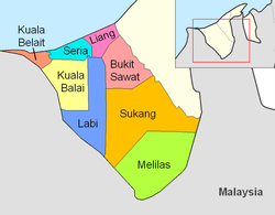
Mukim Bukit Sawat is a mukim in Belait District, Brunei. It had a population of 794 in 2016.

<span class="mw-page-title-main">Mukim Kota Batu</span> Mukim of Brunei

Mukim Kota Batu is a mukim in Brunei-Muara District, Brunei. The population was 12,935 in 2016. The mukim is home to some of the country's museums and historical sites, in particular in Kota Batu.

<span class="mw-page-title-main">Mukim Pengkalan Batu</span> Mukim in Brunei-Muara, Brunei

Mukim Pengkalan Batu is a mukim in Brunei-Muara District, Brunei. The population was 14,492 in 2016.

<span class="mw-page-title-main">Mukim Burong Pingai Ayer</span> Mukim of Brunei

Mukim Burong Pingai Ayer is a mukim in Brunei-Muara District, Brunei. It is located within Kampong Ayer, the traditional stilt settlements on the Brunei River in the capital Bandar Seri Begawan. The population was 1,770 in 2016.

<span class="mw-page-title-main">Mukim Rambai</span> Mukim of Brunei

Mukim Rambai is a mukim in Tutong District, Brunei. The population was 1,404 in 2016.

<span class="mw-page-title-main">Mukim Kuala Balai</span> Mukim of Brunei

Mukim Kuala Balai is a mukim in Belait District, Brunei. The population was 31 in 2016.

<span class="mw-page-title-main">Mukim Melilas</span> Mukim of Brunei

Mukim Melilas is a mukim in Belait District, Brunei. The population was 29 in 2016, the least populous mukim in all of Brunei.

<span class="mw-page-title-main">Mukim Amo</span> Mukim of Brunei

Mukim Amo is a mukim in Temburong District, Brunei. It has an area of 542 square kilometres (209 sq mi); the population was 2,144 in 2016.

<span class="mw-page-title-main">Mukim Labu</span> Mukim of Brunei

Mukim Labu is a mukim in Temburong District, Brunei. It has an area of 292 square kilometres (113 sq mi); the population was 590 in 2016.

<span class="mw-page-title-main">Lumut, Brunei</span> Settlement in Brunei

Kampong Lumut or commonly known as Lumut, is a coastal settlement in Belait District, Brunei, about 30 kilometres (19 mi) from the district town Kuala Belait. The total population was 11,273 in 2016.

Kampong Keriam is a village in Tutong District, Brunei, about 6 kilometres (3.7 mi) from the district town Pekan Tutong. The population was 2,195 in 2016. It is one of the villages within Mukim Keriam, a mukim in the district.

<span class="mw-page-title-main">Kampong Pandan, Brunei</span> Settlement in Brunei

Kampong Pandan is a residential area in Kuala Belait, the principal town of Belait District, Brunei. It has a population of around 16,200 in 2016. It encompasses a housing estate of the country's National Housing Scheme.

<span class="mw-page-title-main">Kampong Sungai Liang</span> Village in Brunei

Kampong Sungai Liang is a village in Belait District, Brunei, about 40 kilometres (25 mi) from the district's principal town Kuala Belait and 20 kilometres (12 mi) from the oil town Seria. The population was 910 in 2016. It is one of the villages within Mukim Liang. The postcode is KC1135.

References

  1. "PWEDB meriahkan Hari Raya Aidilfitri » Media Permata Online". PWEDB meriahkan Hari Raya Aidilfitri. 2022-05-30. Retrieved 2023-01-11.
  2. 1 2 3 4 "Population and Housing Census Update Final Report 2016" (PDF). www.deps.gov.bn. Statistics Department. December 2018. Retrieved 27 June 2021.
  3. "Belait District" (PDF). www.information.gov.bn. 2011. pp. 8–9. Retrieved 28 June 2021.
  4. Brunei (1975). Annual Report - State of Brunei (in Malay). p. 7.
  5. Abdullah, Noor Alifah binti (2004). Struktur bahasa Belait (in Malay). Dewan Bahasa dan Pustaka Brunei, Kementerian Kebudayaan, Belia dan Sukan. p. 2. ISBN   978-99917-0-334-3.