Mukim Bukit Sawat | |
---|---|
![]() Sungai Mau Recreational Park | |
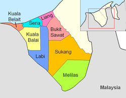
![]() Bukit Sawat is in peach. | |
Country | Brunei |
District | Belait |
Government | |
• Penghulu | Salleh Othman [1] |
Population (2021) [2] | |
• Total | 759 |
Time zone | UTC+8 (BNT) |
Postcode | KFxx38 |
Mukim Bukit Sawat is a mukim in Belait District, Brunei. [3] It had a population of 794 in 2016. [4]
The mukim is located in the east of Belait District, bordering Mukim Telisai, Mukim Ukong and Mukim Rambai of Tutong District to the north, north-east and east respectively, Mukim Sukang to the south, Mukim Labi to the west and Mukim Liang to the north-west.[ citation needed ]
The mukim is named after Kampong Bukit Sawat, one of the villages it encompasses.
As of the 2016 census, [4] the population was 794 with 57.1% males and 42.9% females. The mukim had 220 households occupying 220 dwellings. The entire population lived in rural areas.
As of 2021, the mukim comprised the following villages:
Settlements [2] | Population (2021) [2] | Ketua kampung (2024) [1] [5] |
---|---|---|
Kampong Sungai Mau | 407 | — |
Kampong Bisut | 0 | |
Kampong Bukit Sawat | 98 | Mohammad bin Abdullah @ Lim Swee Ann |
Kampong Pulau Apil | 43 | — |
Kampong Tarap | 11 | |
Kampong Bukit Kandol | 1 | |
Kampong Merangking | 24 | |
Kampong Merangking Ulu | 80 | Raimey bin Abdullah |
Kampong Merangking Hilir | 95 | |
Kampong Melayan | 0 | — |
The primary schools (sekolah rendah) in the mukim include:
Each school also houses a sekolah ugama (school for the country's Islamic religious primary education).
4°27′09″N114°24′04″E / 4.45250°N 114.40111°E