Tutong District

Last updated

Tutong District
Daerah Tutong (Malay)
دائيره توتوڠ (Jawi)
Tutong Town (2).jpg
Tutong River (15042022).jpg
Taman Seri Warisan Emas.jpg
Keriam, Brunei - panoramio.jpg
Clockwise from top left: Tutong, Tutong River, Seri Warisan Emas Park, Penabai
Locator map Tutong in Brunei.svg
Country Brunei
Administrative centre Pekan Tutong
Area
[1]
  Total1,166 km2 (450 sq mi)
Population
 (2016) [2]
  Total48,313
  Estimate 
(2020) [2]
51,500
  Density41/km2 (110/sq mi)
Time zone UTC+8 (BNT)
Postcode
T
Area code 4
Website tutong.gov.bn

Tutong District (Malay : Daerah Tutong; Jawi: دائيره توتوڠ) or simply Tutong is one of the four districts of Brunei. It has an area of 1,166 square kilometres (450 sq mi); the population was 48,313 in 2016. [2] The administrative town is Pekan Tutong. It is home to Tasek Merimbun, the country's largest natural lake.

Contents

History

Tutong was formerly a part of the Melanau administration in the 14th century before joining the Brunei Sultanate in the 15th. [3] Prior to the introduction of the British residential system in Brunei in 1906, Tutong was a kuripan land, a type of land ownership in Brunei's traditional government. It was the non-hereditary land of Pengiran Di-Gadong, one of the four traditional wazir (viziers) to the Sultan. [4] The district have seen a rapid rise in population by nearly 15,000 in 1967. [5]

Geography

The district borders the South China Sea to the north, Brunei-Muara District to the north-east, the Malaysian state of Sarawak to the east and south, and Belait District to the west. With an area of 1,166 square kilometres (450 sq mi), it is the third largest district in Brunei. [1]

The 137-kilometre (85 mi) [6] Tutong River is the sole primary river and only flows in the district. It begins in the district's interior in the south and flows northwards which finally discharges into the South China Sea.

Bukit Bedawan ("Bedawan Hill") is the highest point in the district with a height of 529 metres (1,736 ft).

The district is home to Tasek Merimbun, the largest natural lake in Brunei. It is a designated ASEAN Heritage Park since 29 November 1984. [7]

Administration

Mukims of Tutong District Tutong mukims.png
Mukims of Tutong District

Tutong District is administered by Tutong District Office (Jabatan Daerah Tutong), a government department under the Ministry of Home Affairs.

The district is divided into eight mukims: [1] [8]

Mukim Pekan Tutong encompasses the municipal area of Pekan Tutong.[ citation needed ]

According to the Constitution, the district is to be represented in the Legislative Council, the state legislature, by up to 3 members. [9] As of 2017, two members have been appointed to represent the district in the legislature. [10]

Demographics

Historical population
Census YearPop.±%
1971 15,858    
1981 21,615+36.3%
1991 29,732+37.6%
2001 38,649+30.0%
2011 43,852+13.5%
2016 48,313+10.2%
Source: Department of Statistics [11]

Tutong District is the third most populous district in Brunei. According to the 2016 census update, [11] the population was 48,313 and made up about 11.6% of the country's total population.

The census also recorded 8,578 households living in 8,491 dwellings in the district. [11]

In 2020, the district's population was estimated to have increased to 51,500. [2]

The main ethnic groups in the district consist of Tutong, Dusun, Kedayan, Iban and Chinese. [12]

Healthcare

Pengiran Muda Mahkota Pengiran Muda Haji Al-Muhtadee Billah Hospital, the district hospital Hospital pmmpmhamb 02.08.2018.jpg
Pengiran Muda Mahkota Pengiran Muda Haji Al-Muhtadee Billah Hospital, the district hospital

Healthcare in the district began with the establishment of a medical clinic in 1932 in Bukit Bendera area near the district town Pekan Tutong. [13] During the Japanese occupation of Brunei (1941–1945), the clinic building suffered great damage due to bombing.

In late 1972, the construction of Tutong District Hospital was completed. [14] It could accommodate 20 beds; healthcare services included surgery room, delivery room, x-ray, dental clinic, outpatient and medical laboratory.

The current district hospital is Pengiran Muda Mahkota Pengiran Muda Haji Al-Muhtadee Billah (PMMPMHAMB) Hospital which replaced the former Tutong District Hospital. As of today, it is the sole hospital in the district.

There are also four community health centres located in Pekan Tutong, Kampong Sungai Kelugos, Kampong Telisai and Kampong Lamunin. [15] The health centres mainly provide outpatient care to the residents of the village or mukim where they are located, as well as those that live in the surrounding areas.

National Isolation Centre

National Isolation Centre National Isolation Centre in Tutong, Brunei.jpg
National Isolation Centre

Tutong District is home to the National Isolation Centre (NIC, Pusat Pengasingan Kebangsaan), the country's dedicated medical isolation facility for communicable diseases. Located in a permanent building beside the district hospital, it was inaugurated by the Crown Prince Al-Muhtadee Billah on 13 November 2012 at a cost of B$8.47 million (US$6.26 million as of September 2021 [16] ); [17] it can accommodate 136 beds. [18] It is playing a vital role in the COVID-19 situation in Brunei, whereby it is where COVID-19 patients are isolated and treated. A new extension was built in 2020 in the event the existing facility reached full capacity. [18] The construction was completed in three weeks at a cost of B$11 million (US$8.1 million as of September 2021 [19] ); it can accommodate additional 160 beds. During the COVID-19 outbreak, the adjacent PMMPMHAMB Hospital has also been converted into another extension for the isolation centre. [18]

Education

In 2019, [20] there were 42 schools in Tutong District under the Ministry of Education, out of which 36 were government and 6 were private. The number of teachers were recorded at 1,187, in which

Education in the district is available up to sixth form, which is provided at Tutong Sixth Form Centre (Pusat Tingkatan Enam Tutong), the sole sixth form college in the district.

Government schools

The government schools are mainly administered under the Ministry of Education. There are 30 primary schools, 5 secondary schools and one sixth form college in the district, which are grouped under Cluster 6 of the Ministry's school administrative district. [21]

The five secondary schools are:

These schools offer secondary education that leads to Brunei-Cambridge GCE O Level. [22]

The sole sixth form college of the district is the Tutong Sixth Form Centre and offers sixth form education which leads to GCE A Level. [23]

Ma'had Islam Brunei is the only government school in the district which is not administered by the Ministry of Education. It is administered by the Ministry of Religious Affairs and one of the few schools in the country dedicated to Brunei's Arabic-medium Islamic religious education stream, providing preparatory and secondary levels leading up the Sijil Pelajaran Ugama Brunei (Bruneian Certificate of Religious Education), the O Level equivalent of the stream.

Transportation

As of 2022, the district's road network consisted of 649.69 kilometres (403.70 mi), out of which around 82% were paved. [20]

Places of interest

Tutong has the largest lake in Brunei, Tasek Merimbun, which surrounds the Tasek Merimbun Heritage Park. [24] Other places of interest in Tutong include

Related Research Articles

<span class="mw-page-title-main">Bandar Seri Begawan</span> Capital city of Brunei

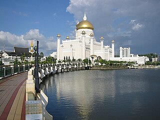
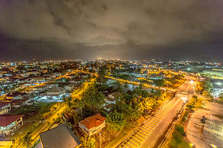
Bandar Seri Begawan is the capital and largest city of Brunei. It is officially a municipal area with an area of 100.36 square kilometres (38.75 sq mi) and an estimated population of 100,700 as of 2007. It is part of Brunei-Muara District, the smallest yet most populous district which is home to over 70 per cent of the country's population. It is the country's largest urban centre and nominally the country's only city. The capital is home to Brunei's seat of government, as well as a commercial and cultural centre. It was formerly known as Brunei Town until it was renamed in 1970 in honour of Sultan Omar Ali Saifuddien III, the 28th Sultan of Brunei and the father of the current Sultan Hassanal Bolkiah.

Districts are the principal administrative divisions of Brunei. The country is divided into four districts, namely Brunei-Muara, Belait, Tutong and Temburong. Temburong is an exclave; it is physically separated from the three other districts by the Brunei Bay and Malaysian state of Sarawak. Each district has a town as its administrative and main economic centre, with the exception of Brunei-Muara, where the principal centre is Bandar Seri Begawan, a city and the country's capital.

<span class="mw-page-title-main">Belait District</span> District of Brunei

Belait District, or simply Belait, is the largest as well as the westernmost district in Brunei. It has an area of 2,727 square kilometres (1,053 sq mi) and the population of 69,062 as of 2016. The administrative town is Kuala Belait, located at the mouth of the Belait River. The district is commonly associated with the oil and gas industry of the country, mainly concentrated near the town of Seria.

<span class="mw-page-title-main">Brunei-Muara District</span> District of Brunei

Brunei-Muara District or simply Brunei-Muara is one of the four districts of Brunei. It has the smallest area among the four districts, with 571 square kilometres (220 sq mi), yet is the most populous, with 289,630 people as of 2016. Bandar Seri Begawan, the country's capital, is located in this district, which is also de facto the district's capital. It is also home to Brunei International Airport, the country's only international airport, as well as Muara Port, the main and only deep-water port in the country. The Brunei River flows within this district and is home to Kampong Ayer, the traditional historic settlement on stilts above the river.

<span class="mw-page-title-main">Temburong District</span> District of Brunei

Temburong District, or simply Temburong is the easternmost district in Brunei. It is an exclave surrounded by Malaysia and the Brunei Bay. Temburong is accessible from Brunei's mainland via the Sultan Haji Omar Ali Saifuddien Bridge. It has a total area of 1,306 km2 (504 sq mi). As of 2016, its population was 10,251; it is the least populous district in Brunei. Bangar is the administrative centre of the Temburong District.

<span class="mw-page-title-main">Kuala Belait</span> Town in Brunei

Kuala Belait is the administrative town of Belait District, Brunei. The population of the town proper was 4,259 in 2016. Kuala Belait is officially a municipal area, as well as a village under the mukim of the same name. The town is located 85 kilometres (53 mi) west of the country's capital Bandar Seri Begawan, and 20 kilometres (12 mi) west of Seria, the district's other town. It is also in the westernmost part of country, near the mouth of the Belait River.

<span class="mw-page-title-main">Bangar, Brunei</span> Town of Temburong District, Brunei

Bangar is a town and administrative centre of Temburong District, Brunei, an isolated territorial exclave separated from the rest of the country by the Malaysian state of Sarawak. The population of the town proper was 451 in 2021. A number of tiny retail establishments may be found throughout the town, providing everything from clothing to handicrafts to basic needs.

<span class="mw-page-title-main">Tutong (town)</span> Municipality in Brunei

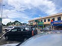
Tutong is a municipality town in Mukim Pekan Tutong Tutong District, Brunei. It is located about 40 kilometres (25 mi) from the country's capital Bandar Seri Begawan. It is the administrative centre of Tutong District.

<span class="mw-page-title-main">Kampong Ayer</span> Traditional settlement in Brunei

Kampung Ayer is a prominent traditional settlement in Bandar Seri Begawan, the capital of Brunei. It comprises neighbourhoods of traditional houses, schools and mosques built on stilts above the Brunei River near the capital's city centre. It has an area of about 10 square kilometres (3.9 sq mi); the total population was 10,250 in 2016. It has been historically nicknamed 'Venice of the East'. Kampung Ayer has been historically the principal settlement of Brunei; it was the de facto capital, in particular social and economic centre, of the Bruneian Empire for a few centuries, but also extending into the early period during British imperialism in Brunei.

The administrative divisions of Brunei mainly consist of daerah (districts), mukim (subdistricts) and kampung or kampong (villages). They are organised hierarchically, with daerah being the first level and kampong the third level.

<span class="mw-page-title-main">Kampong Keriam</span> Village in Brunei

Kampong Keriam is a village in Tutong District, Brunei, about 6 kilometres (3.7 mi) from the district town Pekan Tutong. The population was 2,195 in 2016. It is one of the villages within Mukim Keriam, a mukim in the district.

<span class="mw-page-title-main">Ministry of Religious Affairs (Brunei)</span> Bruneian government ministry

The Ministry of Religious Affairs (MORA or MoRA; Malay: Kementerian Hal Ehwal Ugama, KHEU) is a cabinet-level ministry in the government of Brunei which is responsible for the propagation of Islam and its upholding as the state religion, as well as oversees the Islamic religious education in the country. It is currently led by a minister and a deputy minister, whereby the incumbents are Badaruddin Othman and Pengiran Mohd Tashim Pengiran Hassan respectively. The ministry is headquartered in Bandar Seri Begawan.

<span class="mw-page-title-main">Muda Hashim Secondary School</span> Secondary school in Tutong, Brunei

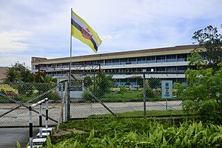
Muda Hashim Secondary School is a government boys' secondary school in Tutong, the town of Tutong District in Brunei. The school provides five years of general secondary education leading up to O Level qualification. It has 636 students. The current principal is Mohamad Saiful Bahrin bin Sabri.

<span class="mw-page-title-main">Kampong Bukit Beruang, Brunei</span> Public housing estate in Tutong, Brunei

Kampong Bukit Beruang, also simply known as Bukit Beruang, is a village in Tutong District, Brunei, about 13 kilometres (8.1 mi) from the district town Pekan Tutong. The population was 6,157 in 2016. It is one of the villages within Mukim Telisai, a mukim subdivision in the district. It comprises the original village settlement as well as the public housing estate Bukit Beruang National Housing Scheme.

<span class="mw-page-title-main">Kampong Telisai</span> Village in Brunei

Kampong Telisai, also simply known as Telisai, is a coastal village in Tutong District, Brunei, about 17 kilometres (11 mi) from the district town Pekan Tutong. The village also encompasses the public housing area STKRJ Kampong Telisai. The population was 2,293 in 2016. It is one of the villages within Mukim Telisai. The postcode is TC1145.

<span class="mw-page-title-main">Kampong Kiarong</span> Village in Brunei

Kampong Kiarong or commonly known as Kiarong, is a village in Brunei-Muara District, Brunei, as well as a neighbourhood in the country's capital Bandar Seri Begawan. It has an area of 383.43 hectares ; the population was 4,530 in 2016.

<span class="mw-page-title-main">Kampong Sengkarai</span> Village in Brunei

Kampong Sengkarai is a village in Tutong District, Brunei, on the outskirts of the district town Pekan Tutong. The population was 1,694 in 2021. It is one of the villages within Mukim Pekan Tutong.

<span class="mw-page-title-main">Batu Satu</span> Area in Bandar Seri Begawan, Brunei

Batu Satu, also known as Kampong Parit, is an area in Bandar Seri Begawan, the capital of Brunei. It is also a designated village in Brunei-Muara District, within Mukim Kianggeh. The population was 1,509 in 2016. It encompasses a commercial area of the capital. It is also home to the country's Supreme Court, as well as some of important Islamic religious educational institutions of the country.

<span class="mw-page-title-main">Kampong Penabai</span> Village in Brunei

Kampong Penabai is a coastal village in Tutong District, Brunei, about 4–5 kilometres (2.5–3.1 mi) from the district town Pekan Tutong. The population was 749 in 2021. It is one of the villages within Mukim Pekan Tutong, a mukim in the district.

<span class="mw-page-title-main">Abu Bakar Umar</span> Bruneian politician

Pengiran Abu Bakar MBE was a nobleman, civil servant, and politician who became the fifth Speaker of the Brunei legislative council, serving from 1 December 1974 until his retirement on 14 December 1981. Notably, he is the father-in-law to Princess Masna Bolkiah.

References

  1. 1 2 3 Tutong District (PDF) (7th ed.). Information Department. 2013. ISBN   978-9991749341 . Retrieved 19 October 2017.
  2. 1 2 3 4 "Department of Economic Planning and Development - Population". www.depd.gov.bn. Retrieved 19 October 2017.
  3. Mohd Yunos, Rozan (2013). SEMINAR UNITED NATIONS GROUP OF EXPERTS ON GEOGRAPHICAL NAMES ASIA, SOUTHEAST DIVISION (PDF). p. 22.
  4. Horton, A. V. M. (1987). "The Disturbances in the Tutong and Belait Districts of Brunei (1899-1901)" . Journal of Southeast Asian Studies. Cambridge University Press on behalf of National University of Singapore. 18 (1): 93–107. doi:10.1017/S0022463400001272. JSTOR   20070944. S2CID   163087527 . Retrieved 3 August 2021.
  5. "Pembangunan Daerah Tutong Di-Pesatkan" (PDF). Pelita Brunei. 5 April 1967. pp. 4–5.
  6. Bac-Bronowicz, Joanna; Becek, Kazimierz (2021). "Environmentally based perception of space". ResearchGate . Retrieved 4 August 2021.
  7. Fadley Faisal (31 December 2020). "Tasek Merimbun Heritage Park closed for maintenance" . Borneo Bulletin Online . Retrieved 4 August 2021.
  8. "Jabatan Daerah Tutong, Kementerian Hal Ehwal Dalam Negeri - Mukim-Mukim di Daerah Tutong". tutong.gov.bn (in Malay). Retrieved 10 October 2017.
  9. "CONSTITUTIONAL DOCUMENTS" (PDF). www.agc.gov.bn. p. 179. Retrieved 27 October 2021.
  10. "Pelantikan keahlian Majlis Mesyuarat Negara baharu" (PDF). Pelita Brunei (in Malay). No. 62 #6 (published 14 January 2017). Jabatan Penerangan. 12 January 2017. pp. 1, 2. Retrieved 27 October 2021.
  11. 1 2 3 "Population and Housing Census Update Final Report 2016" (PDF). www.deps.gov.bn. Department of Statistics. December 2018. Retrieved 1 August 2021.
  12. "Jabatan Daerah Tutong, Kementerian Hal Ehwal Dalam Negeri - Profail Tutong". tutong.gov.bn (in Malay). Retrieved 29 September 2017.
  13. "Puak Tutong", 2004, p. 138
  14. "Puak Tutong", 2004, p. 139
  15. "Tutong District" (PDF). p. 21. Retrieved 2 September 2018.
  16. "XE: Convert BND/USD. Brunei Darussalam Dollar to United States Dollar". XE.com . Retrieved 25 September 2021.
  17. Rohani Haji Abdul Hamid; Aryentty Haji Ariffin (13 November 2012). "DPMM berangkat rasmikan Pusat Pengasingan Kebangsaan" (PDF). Pelita Brunei (in Malay) (published 14 November 2012). Jabatan Penerangan. pp. 12–13. Retrieved 25 September 2021.
  18. 1 2 3 Rasidah Hj Abu Bakar (24 April 2020). "New isolation centre building set to more than double number of beds". The Scoop. Retrieved 25 September 2021.
  19. "XE: Convert BND/USD. Brunei Darussalam Dollar to United States Dollar". XE.com . Retrieved 25 September 2021.
  20. 1 2 BRUNEI DARUSSALAM STATISTICAL YEARBOOK 2022 (PDF). Department of Economic Planning and Statistics. 2022. ISBN   9789991772479 . Retrieved 11 January 2024.
  21. (in English) "Government". Ministry of Education, Brunei Darussalam. Retrieved 10 September 2016.
  22. (in English) "Secondary Education". Ministry of Education, Brunei Darussalam. Retrieved 10 September 2016.
  23. (in English) "Post Secondary Education". Ministry of Education, Brunei Darussalam. Retrieved 10 September 2016.
  24. (in English) Tasek Merimbun Heritage Park

4°35′N114°40′E / 4.583°N 114.667°E / 4.583; 114.667