
Mukim Lamunin is a mukim in Tutong District, Brunei. The population was 4,298 in 2016.

Mukim Kuala Balai is a mukim located in the Belait District of Brunei, known for its unique geographical setting. As of 2016, the population was recorded at just 31 residents. The village of Kampong Kuala Balai is situated in the upper Kumgang region of Belait, forming part of the Mukim Kuala Balai catchment area. It is located approximately 28 kilometres (17 mi) from Kuala Belait. However, Kampong Kuala Balai is currently uninhabited due to factors such as migration to other villages and employment opportunities elsewhere, leading to a decline in its once-thriving community. It is an early settlement of the Belait people, who formed the majority of its population, and it once served as the administrative center for the Belait District during traditional governance and British residency, while also being a prominent exporter of ambulong (sago) in its heyday.

Mukim Bangar is a mukim in Temburong District, Brunei. It has a total area of 113 square kilometres (44 sq mi); the population was 2,112 in 2021. The mukim encompasses Bangar, the district's sole town and administrative centre.

Kampong Jerudong is a village in Mukim Sengkurong, Brunei–Muara District, Brunei, about 21 kilometres (13 mi) from the capital Bandar Seri Begawan. The population was 3,856 in 2016. It is one of the settlements within Mukim Sengkurong. It is of historical interest as it is considered the starting point for the Kedayan community and where they first introduced rice cultivation. There are various stories about the origins of the Kedayan people, with some suggesting they came from Java. According to one account, Sultan Bolkiah brought the Kedayan to teach rice cultivation to his people, and they first settled in Kampong Pasir, Jerudong.

Kampong Keriam is a village located in the Tutong District of Brunei, within the mukim of Keriam. Located approximately 2 kilometres (1.2 mi) from Tutong town, it had a population of 1,980 in 2021, predominantly comprising the Tutong ethnic group. Originally an area for paddy and rubber cultivation, it transformed into a village in 1924 when residents from nearby settlements, including Kampong Penanjong, Panchor Papan, Penampang, and Kelakas, relocated there. The village's growth was further supported by the development of the main road in the Tutong District during the 1920s, establishing it as a thriving residential area.
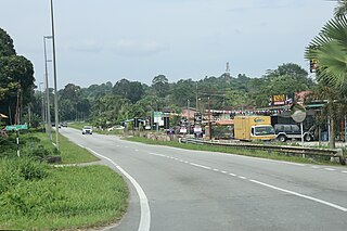
Kampong Kiudang or simply known as Kiudang, is a village in Tutong District, Brunei, about 24 kilometres (15 mi) from the district town Pekan Tutong. The population was 1,258 in 2016.
Kampong Luagan Dudok is a village in the north-east of Tutong District, Brunei. The population was 879 in 2016. It is one of the villages within Mukim Keriam, mukim in the district.

Kampong Bukit Panggal is a village in Tutong District, Brunei, about 10 kilometres (6.2 mi) from the district town Pekan Tutong. The population was 801 in 2016. It is one of the villages within Mukim Keriam, a mukim in the district.

Kampong Sengkarai is a village located in the Tutong District of Brunei, within the mukim of Pekan Tutong. With a postcode of TA2341, the village is situated approximately 2 kilometres (1.2 mi) from the town of Tutong. As of 2021, the population of the village was 1,694, comprising Tutong, Brunei Malay, and other ethnic groups.

Kampong Sungai Hanching is a village in Brunei-Muara District, Brunei. The population was 2,987 in 2016. It is one of the villages within Mukim Berakas 'B'. The postcode is BC2115.

Kampong Buang Tekurok is a village-level subdivision of Lumapas, a mukim (subdistrict) of Brunei–Muara District, Brunei. The postcode for Kampong Buang Tekurok is BJ2524.
Kampong Tanjong Maya is a village located in the Tutong District of Brunei, within the mukim of Tanjong Maya, and has the postcode TA1941. Located approximately 12 kilometres (7.5 mi) from Tutong town, the village borders Kampong Bukit Udal, Penapar, and Lubok Pulau. With a population of 488 in 2016, the majority of its residents belong to the Tutong ethnic group.

Kampong Ukong or simply known as Ukong, is a village in the central part of Tutong District, Brunei, about 20 kilometres (12 mi) from the district town Pekan Tutong. The population of the village proper was 381 in 2016. It is one of the villages within Mukim Ukong, a mukim in the district.
Kampong Bakiau is a village in the north-east of Tutong District, Brunei, about 23 kilometres (14 mi) from the district town of Tutong, Mukim Kiudang. It has an area of 1.3 square kilometres (0.50 sq mi); the population was 169 in 2021.

Kampong Birau is a village located in the Tutong District of Brunei, within the mukim of Kiudang. Covering an area of 13.5 square miles (35 km2), the village had a population of 918 in 2021. Located about 26 kilometres (16 mi) from Tutong town, it is bordered by Kampong Luagan Timbaran and Kebia. The village's postcode is TE2143.

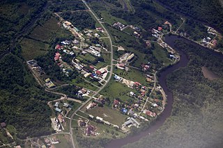
Kampong Kuala Tutong, also simply known as Kuala Tutong, is a village in Tutong District, Brunei, within the mukim of Pekan Tutong. The postcode for Kampong Kuala Tutong is TA3341. Kampong Kuala Tutong covers 1.3 square kilometres (0.50 sq mi) from the mosque to the river's mouth. Before World War II, a ferry jetty was constructed at the end of Jalan Kuala Tutong, approximately 5 kilometres (3.1 mi) from Kampong Penabai. Since no bridges connected the Tutong and Belait districts at that time, the Brunei government introduced a ferry service in 1930, which operated from Kuala Sungai Tutong. This ferry became a crucial transportation link for vehicles traveling between Brunei Town, Tutong, Seria, and Kuala Belait. However, the service ceased in 1958 following the completion of bridges in Serambangun and Telamba, which made the ferry redundant.

Kampong Panchor Papan is a village located in the Tutong District of Brunei, within the mukim of Pekan Tutong. The village's postcode is TA1941. The name Panchor is shared by several villages in Brunei, including Kampong Panchor Murai in the Brunei–Muara District, as well as Kampong Panchor Papan and Kampong Panchor Dulit in the Tutong District. Today, Kampong Panchor Papan and Kampong Panchor Dulit are administratively combined under the name Kampong Panchor, with both villages being led by a ketua kampung.

Kampong Penabai is a coastal village located in the Tutong District of Brunei, within the mukim of Pekan Tutong. The village's postcode is TA3541. Located approximately 4–5 kilometres (2.5–3.1 mi) from the district town of Tutong, the village had a population of 749 in 2021. It originated in the early 20th century as a Brunei Malay settlement, previously known as Kampong Kuala Tutong, which spanned from Seri Kenangan Beach to the mouth of the Tutong River. Kampong Penabai covers 1.5 square kilometres (0.58 sq mi) from Seri Kenangan Beach to Kampong Penabai Mosque.
Kampong Sungai Besar or commonly known as Sungai Besar, is a village in the east of Brunei-Muara District, Brunei, near the mouth of the Brunei River with the Brunei Bay. The population was 2,039 in 2016.

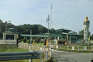
Basir bin Taha was a Bruneian teacher, school inspector, and welfare officer who made significant contributions to education, welfare, and religion in Brunei. He played a key role in shaping the nation's educational system, founding the Brunei Malay Teachers Association (PGGMB) and helping restructure religious education. Basir also revitalised the Scout movement, founded the Kampong Birau Mosque, and contributed to welfare initiatives. As a member of the Kesatuan Melayu Brunei and advisor to then-Prince Omar Ali Saifuddien.


