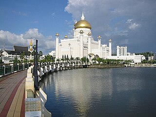
The Brunei–Muara District or simply Brunei–Muara is one of the four districts of Brunei. It has the smallest area among the four districts, with 571 square kilometres (220 sq mi), yet is the most populous, with 289,630 people as of 2016. Bandar Seri Begawan, the country's capital, is located in this district, which is also de facto the district's capital. It is also home to Brunei International Airport, the country's only international airport, as well as Muara Port, the main and only deep-water port in the country. The Brunei River flows within this district and is home to Kampong Ayer, the traditional historic settlement on stilts above the river.

Mukim Kuala Belait is a mukim in Belait District, Brunei. The population was 31,308 in 2016. The mukim encompasses Kuala Belait, the administrative town of the district.

Mukim Kianggeh is a mukim in Brunei-Muara District, Brunei. The population was 8,228 in 2016. The mukim encompasses Pusat Bandar, the city centre of the capital Bandar Seri Begawan.

Mukim Berakas 'A' is a mukim in Brunei-Muara District, Brunei Darussalam. The population was 27,223 in 2016.

Mukim Berakas 'B' is a mukim in Brunei-Muara District, Brunei.

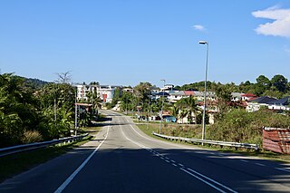
Mukim Kota Batu is a mukim in Brunei-Muara District, Brunei. The population was 12,935 in 2016. The mukim is home to some of the country's museums and historical sites, in particular in Kota Batu.

Mukim Burong Pingai Ayer is a mukim in Brunei-Muara District, Brunei. It is located within Kampong Ayer, the traditional stilt settlements on the Brunei River in the capital Bandar Seri Begawan. The population was 1,770 in 2016.

Mukim Peramu is a mukim in Brunei-Muara District, Brunei. It is located within Kampong Ayer, the historical stilt settlements on the Brunei River in the capital Bandar Seri Begawan. The population was 1,111 in 2016.

Mukim Sungai Kebun is a mukim in Brunei–Muara district, Brunei. It is part of Kampong Ayer, the traditional stilt settlements on the Brunei River in the capital Bandar Seri Begawan. The population was 4,750 in 2016.
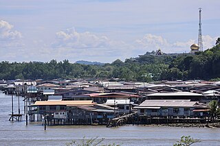
Mukim Tamoi is a mukim in Brunei-Muara District, Brunei. It is part of Kampong Ayer, the traditional stilt settlements on the Brunei River in the country's capital Bandar Seri Begawan. The population was 1,389 in 2016.

Mukim Amo is a mukim in Temburong District, Brunei. It has an area of 542 square kilometres (209 sq mi); the population was 1,657 in 2021.
Kampong Rimba is a village on the outskirts of Bandar Seri Begawan, the capital of Brunei. It is one of the village subdivisions under Mukim Gadong 'A', a mukim in Brunei-Muara District. The population was 5,013 in 2016.

Taman Mahkota Jubli Emas, initially known as Eco-Corridor Park, is a riverfront public park in the former Mukim Sungai Kedayan of Bandar Seri Begawan, Brunei. The park was inaugurated on 22 October 2017 in conjunction with the Golden Jubilee of Sultan Hassanal Bolkiah's accession to the throne as the 29th and current Sultan of Brunei.

Kampong Pancha Delima is a village in Brunei-Muara District, Brunei, and a neighbourhood in the capital Bandar Seri Begawan. The population was 1,562 in 2016. It is one of the villages within Mukim Berakas 'A'. The postcode is BB4513.
Kampong Perpindahan Mata-Mata or simply known as Perpindahan Mata-Mata, is a public housing estate and designated village in Brunei-Muara District, Brunei, on the outskirts of the capital Bandar Seri Begawan. The population was 2,385 in 2016. It is one of the villages within Mukim Gadong 'B'. The postcode is BE1918.

Kampong Menglait or simply known as Menglait, is a village in Brunei-Muara District, Brunei, as well as a neighbourhood and commercial area in the capital Bandar Seri Begawan. The population was 2,262 in 2016. It is one of the villages within Mukim Gadong 'B'. The postcode is BE3919.

Kampong Lupak Luas or simply known as Lupak Luas, is a village-level subdivision of Lumapas, a mukim (subdistrict) of Brunei-Muara District, Brunei. The postcode for the village is BJ2524.
Kampong Sungai Besar or commonly known as Sungai Besar, is a village in the east of Brunei-Muara District, Brunei, near the mouth of the Brunei River with the Brunei Bay. The population was 2,039 in 2016.
Kampong Belimbing or silly known as Belimbing, is a village in Brunei-Muara District, Brunei. It is also a neighbourhood in the capital Bandar Seri Begawan. The population was 2,721 in 2016. It is one of the villages within Mukim Kota Batu. The postcode is BD2917.


