Mukim Melilas

Last updated

Mukim Melilas
Melilas.jpg
Kampong Melilas
Belait mukims.png
Melilas is in green.
Country Brunei
District Belait
Government
   Penghulu Lim Swee Ann [1]
Area
  Total602.803 km2 (232.744 sq mi)
Population
 (2016) [2]
  Total29
  Density0.048/km2 (0.12/sq mi)
Time zone UTC+8 (BNT)
Postcode
KHxx39

Mukim Melilas is a mukim in Belait District, Brunei. [3] The population was 29 in 2016, the least populous mukim in all of Brunei. [2] It is considered the final and most isolated settlement in Belait, and maybe all of Brunei. [4]

Contents

Name

According to the history of the people living in the village, the word 'melilas' comes from the Iban word 'mengilas' which refers to a tree whose wood is used by the Iban tribe for cooking. Behind the original word which is 'mengilas' it is said in an expression that is wrong in terms of spelling and sound which is 'melilas' and until now the village remains under the name of Kampong Melilas. The mukim could be named after a village it emcopasses, Kampong Melilas. [5]

Geography

Map of the village subdivisions in Melilas. KampongsOfMelilas.png
Map of the village subdivisions in Melilas.

The mukim is located in the interior and southernmost part of the district as well as the country. It borders Mukim Sukang to the north and the Malaysian state of Sarawak to the east, south and west.[ citation needed ]

Mukim Melilas is covered with an expanse of green primary forest with plantations that can be seen on the roadside. [5]

Demography

As of 2021 census, [6] the population of Mukim Melilas had a population of 29: 15 males and 14 females. The mukim had 13 households occupying thee dwellings. The entire population lived in rural areas. Although most of the people in the village moved or worked in towns or urban areas, during school holidays and the Gawai Dayak and Hari Raya, they will return en masse to celebrate the festivities. [5]

Administration

There are 3 villages in Melilas.

Villages

Kampong Melilas

It was claimed by the acting ketua kampung that the villagers arrived in Bukit Tuding (Tuding Hill), which was their original settlement, by traveling down the coast from Marudi, Sarawak, Malaysia prior to the outbreak of World War II (before 1939). They eventually relocated to a community along the Belait River (Melilas River). After a while, they moved down to the river area in 1959, where they stayed until they moved into their current location in 1974. [5]

There are two villages under Kampong Melilas's administration, namely Rumah Panjang (Longhouse) Julangan Titah Kampung Melilas or before that known as Rumah Panjang Melilas and Rumah Panjang Bebalat. Julangan Titah Longhouse has 15 doors and is inhabited by approximately 280 people of which 90 percent are Muslims while Bebalat Longhouse has five doors and is inhabited by 50 residents. As opposed to earlier, when they had to draw water from the adjacent river, the new longhouse has power equipment, water pumps, and water tanks at each entrance, donated by the Sultan of Brunei. Beginning in mid-December 2015 and lasting for eight months until the replica house keys were handed over on 20 June 2016, building on the long house was under way. [5]

Economy

Most of the residents of Kampong Melilas practice a subsistence economy such as growing rice, gardening, collecting forest and river produce. It has its own Majlis Perundingan Kampungnya (MPK) by making handicrafts and weaving as 1K1P products. Among them are tudung saji, nyiru, small mats, takiding and others made of bamboo and rattan. The Sungai Ingei Conservation Forest region may also be reached via Kampong Melilas, which follows the stream. This region, which has a size of around 18,491 hectares, is a forest reserve area under the management of the Forestry Department. In Sarawak, Malaysia, on the edge of the Gunung Mulu National Park, is the Sungei Ingei Conservation Forest. This location is also situated in a region designated as a management region to support Brunei's execution of the Heart of Borneo Initiative. [5]

Transportation

Road

The lengthy, meandering Jalan Labi, which is over 50 kilometers in length, is where the journey to Belait's south begins. Even though it is short, the road is totally made of tarmac, making it safe for small sedans to travel all the way to the finish, where there is another Iban encampment called the Teraja Longhouse. A connection to the east, halfway along Jalan Labi, takes you to Jalan Merangking. From here, one travels farther south, first stopping at Mukim Sukang and then continuing on to Melilas. In the few years that followed, it became standard practice to avoid traveling alone, particularly during the rainy season. The trip took at least three hours for the uninitiated, whether they were traveling from Kuala Belait or the capital. [4] Provided with greenery along the journey in the form of forest trees of different sizes, and occasionally coming across little houses constructed by the people. The summit of Mount Mulu, which can be seen from Kampong Melilas as the car ascends the mountainous route. The road leading into Mukim Melilas has already been renovated to concrete, which undoubtedly makes life easier and more comfortable for both the villages and the general public who wish to travel there. [5]

Air

The community's medical requirements were supported by the construction of a helipad and a linked access path, which also accommodated notable guests. [4]

Infrastructure

The amenities and infrastructure that the Sultan provides, such as the village worship center, Melilas Primary School with teacher residences, and other things, are also available to Mukim Melilas. There is a room in Rumah Panjang Julangan Titah that may be used for free by people who have been assigned to Kampung Melilas and want to spend the night there. [5] By the end of 2015, the only longhouse in the final village of Melilas was over 40 years old and in critical condition. Despite the fact that termites had eaten through the structure's hardwood floors and stilts, which compromised the whole basis, the community's major concern was their leaking roof. [4]

The mandate was swiftly started under Julangan Titah, a unique initiative sponsored by donations from the public and commercial sectors as well as from individuals and managed by a secretariat made up of top government officials and Prime Minister's Office. The first time trucks, excavators, and cranes were heard in Melilas in October 2016; locals recollect construction workers working shifts from early in the morning until late at night. Eight months later, there was without a doubt Brunei's biggest longhouse, and at $2 million, it was also reputedly the most costly. [4]

The government cleared woodland in 2006 to build the first land route to Melilas. Those with the means purchased 4x4 cars, shod them with mud terrain tires, and made the jarring trip up the twisting, mountainous path. A two-year Faunal Biodiversity Survey conducted at the Sungei Ingei Conservation Forest to the attention of the nation in 2010. The originally orange-brown dirt walkway is now covered to varied degrees with gravel and cement. Any automobile should be able to reach Brunei's border by the middle of 2018 if the road improvement is completed and the potholes and cracked pavement along Jalan Merangking are repaired. [4]

Related Research Articles

<span class="mw-page-title-main">Belait District</span> District of Brunei

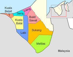
Belait District, or simply Belait, is the largest as well as the westernmost district in Brunei. It has an area of 2,727 square kilometres (1,053 sq mi) and the population of 69,062 as of 2016. The administrative town is Kuala Belait, located at the mouth of the Belait River. The district is commonly associated with the oil and gas industry of the country, mainly concentrated near the town of Seria.

<span class="mw-page-title-main">Kuala Belait</span> Town in Brunei

Kuala Belait is the administrative town of Belait District, Brunei. The population of the town proper was 4,259 in 2016. Kuala Belait is officially a municipal area, as well as a village under the mukim of the same name. The town is located 85 kilometres (53 mi) west of the country's capital Bandar Seri Begawan, and 20 kilometres (12 mi) west of Seria, the district's other town. It is also in the westernmost part of country, near the mouth of the Belait River.

The administrative divisions of Brunei mainly consist of daerah (districts), mukim (subdistricts) and kampung or kampong (villages). They are organised hierarchically, with daerah being the first level and kampong the third level.

<span class="mw-page-title-main">Panaga</span> Village in Brunei

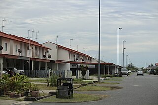
Panaga is a coastal settlement on the north-east coast of the island of Borneo, in the Bruneian district of Belait. Officially known as Kampong Panaga, it is a village-level subdivision under Seria, a mukim or subdistrict of Belait. The settlement of Panaga comprises a public housing estate under the National Housing Scheme and the housing estate of Brunei Shell Petroleum (BSP), the main oil and gas company in the country. Panaga is also home to the headquarters of the company itself. The postcode for Panaga is KB4533.

<span class="mw-page-title-main">Mukim Seria</span> Mukim of Brunei

Mukim Seria is a mukim in Belait District, Brunei. It has an area of 169 square kilometres (65 sq mi); the population was 21,214 in 2016. The mukim encompasses Seria, one of the only two towns in the district. It is home to the oil and gas industry of the country.

<span class="mw-page-title-main">Mumong</span> Settlement in Brunei

Kampong Mumong or simply known as Mumong, is a residential suburb of Kuala Belait, the principal town of Belait District, Brunei. It comprises the original Mumong settlement, as well as the Mumong public housing estate of the Landless Indigenous Citizens' Housing Scheme. However, it officially consists of two village subdivisions, namely Mumong 'A' and Mumong 'B', which are under the mukim of Kuala Belait.

<span class="mw-page-title-main">Rasau</span> Onshore oil field in Brunei

Rasau is an area in Brunei. The area contains one of the two oil fields of Brunei, the Rasau Field, and a small village, Kampong Rasau, which has a population of 103.

<span class="mw-page-title-main">Mukim Labi</span> Mukim of Brunei

Mukim Labi is a mukim in the interior of Belait District, Brunei. It has an area of 361.8 square kilometres (139.7 sq mi); the population was 1,216 in 2016.

<span class="mw-page-title-main">Mukim Bukit Sawat</span> Mukim of Brunei

Mukim Bukit Sawat is a mukim in Belait District, Brunei. It had a population of 794 in 2016.

<span class="mw-page-title-main">Mukim Kilanas</span> Mukim of Brunei

Mukim Kilanas is a mukim in Brunei-Muara District, Brunei. The population was 22,492 in 2016.

<span class="mw-page-title-main">Mukim Rambai</span> Mukim of Brunei

Mukim Rambai is a mukim in Tutong District, Brunei. The population was 1,404 in 2016.

<span class="mw-page-title-main">Mukim Tanjong Maya</span> Mukim of Brunei

Mukim Tanjong Maya is a mukim in Tutong District, Brunei. The population was 4,062 in 2016.

<span class="mw-page-title-main">Mukim Kuala Balai</span> Mukim of Brunei

Mukim Kuala Balai is a mukim in Belait District, Brunei. The population was 31 in 2016.

<span class="mw-page-title-main">Mukim Liang</span> Mukim of Brunei

Mukim Liang is a mukim in Belait District, Brunei. The population was 14,301 in 2016.

<span class="mw-page-title-main">Mukim Sukang</span> Mukim of Brunei

Mukim Sukang is a mukim in Belait District, Brunei. The population was 169 in 2016.

<span class="mw-page-title-main">Mukim Bangar</span> Mukim of Brunei

Mukim Bangar is a mukim in Temburong District, Brunei. It has a total area of 113 square kilometres (44 sq mi); the population was 2,112 in 2021. The mukim encompasses Bangar, the district's sole town and administrative centre.

<span class="mw-page-title-main">Lumut, Brunei</span> Settlement in Brunei

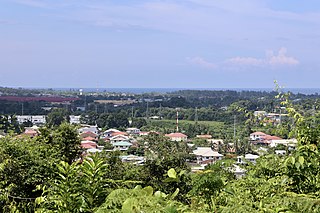
Kampong Lumut or commonly known as Lumut, is a coastal settlement in Belait District, Brunei, about 30 kilometres (19 mi) from the district town Kuala Belait. The total population was 11,273 in 2016.

<span class="mw-page-title-main">Kampong Pandan, Brunei</span> Settlement in Brunei

Kampong Pandan or simply known as Pandan, is a residential area in Kuala Belait, the principal town of Belait District, Brunei. It has a population of around 16,200 in 2016. It encompasses a housing estate of the country's National Housing Scheme.

<span class="mw-page-title-main">Kampong Danau</span> Village in Brunei

Kampong Danau, simply known as Danau, is a coastal village in Tutong District, Brunei, about 21 kilometres (13 mi) from the district town Pekan Tutong. It has a total area of 6.5023 square kilometres (2.5106 sq mi); the total population was 1,072 in 2016. It is one of the villages within Mukim Telisai.

<span class="mw-page-title-main">Kampong Sungai Liang</span> Village in Brunei

Kampong Sungai Liang or simply Sungai Liang, is a village in Belait District, Brunei, about 40 kilometres (25 mi) from the district's principal town Kuala Belait and 20 kilometres (12 mi) from the oil town Seria. The population was 910 in 2016. It is one of the villages within Mukim Liang. The postcode is KC1135.

References

  1. "Direktori Penghulu, Ketua Kampung, dan Ketua Rumah Panjang - Pengiran Ahmad Bin Pengran Haji Mahmud". www.belait.gov.bn. Retrieved 11 January 2023.
  2. 1 2 "Population and Housing Census Update Final Report 2016" (PDF). www.deps.gov.bn. Statistics Department. December 2018. Retrieved 27 June 2021.
  3. "Belait District" (PDF). www.information.gov.bn. 2011. pp. 8–9. Retrieved 28 June 2021.
  4. 1 2 3 4 5 6 Wong, Aaron (5 October 2017). "The story behind the revival of Brunei's most remote settlement". Biz Brunei. Retrieved 28 July 2023.
  5. 1 2 3 4 5 6 7 8 KOMPILASI RENCANA KNK 2018 (PDF) (in Malay). Kenali Negera Kitani. 2018. pp. 66–71.
  6. "Melilas (Mukim, Brunei) - Population Statistics, Charts, Map and Location". www.citypopulation.de. Retrieved 29 December 2022.

4°14′N114°40′E / 4.233°N 114.667°E / 4.233; 114.667