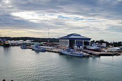
Mukim Serasa

Last updated

Mukim Serasa
BN-muara-marine-2.jpg
Brunei and Muara mukims.png
Serasa is in pink.
Coordinates: 5°00′29″N115°03′09″E / 5.00806°N 115.05250°E / 5.00806; 115.05250 Coordinates: 5°00′29″N115°03′09″E / 5.00806°N 115.05250°E / 5.00806; 115.05250
Country Brunei
District Brunei-Muara
Population
 (2016) [1]
  Total16,173
Time zone UTC+8 (BNT)
Postcode
BTxx28

Mukim Serasa is a mukim in Brunei-Muara District, Brunei. The population was 16,173 in 2016. [1] The mukim encompasses Muara Town, home to Muara Port, the country's only deepwater port.

Contents

Geography

Mukim Serasa is the north-easternmost mukim in the district, its land border is only with Mukim Mentiri to the west; the rest are bounded by the South China Sea to the north and the Brunei Bay to the east and south.

There are several island bodies off the coast of Serasa and the two which are well-known include Pelong Rocks (Malay : Pulau Pilong-Pilongan) and Pulau Muara Besar. There are also two sand spits found on its coast: Pelumpong Spit, which is originally a spit but has become a narrow island when an artificial channel was cut to provide access to Muara Port; [2] and Serasa Spit, an artificial spit.

Demographics

As of the 2016 census, [1] the population of Mukim Serasa comprised 8,770 males and 7,403 females. The mukim had 2,946 households occupying 2,878 dwellings. The entire population lived in urban areas.

Villages

The mukim encompasses the following village subdivisions: [1]

VillagePopulation
(2016)
Notes
Muara Town 2,102-
Kampong Kapok 2,791-
Kampong Meragang 7,668Includes the public housing estate RPN Meragang
Kampong Sabun 412-
Kampong Serasa 3,200Includes the public housing estate Perpindahan Serasa
Total16,173-

Facilities

Education

Pengiran Isteri Hajjah Mariam Secondary is the only secondary school within the mukim.

Meragang Sixth Form Centre, one of the few sixth form colleges in the country, is located in Kampong Meragang.

Mosques

Places of interest

The coast of Serasa which borders the South China Sea is lined with the beaches of Meragang, Muara, and Tanjong Batu and they have been designated as places of recreation for the public.

The coast of the artificial Serasa Spit is also lined with beach features. The area of this Serasa Beach has also been made into a public recreational area. [3]

Brooketon Colliery is a disused coal mine. It was developed during the period of Charles Brooke's rule of Sarawak in the late 19th and early 20th centuries.

Muara Naval Base is home to the base of the Royal Brunei Navy. [4] [5]

Related Research Articles

<span class="mw-page-title-main">Brunei-Muara District</span> District of Brunei

Brunei-Muara District or simply Brunei-Muara is one of the four districts of Brunei. It has the smallest area among the four districts, with 571 square kilometres (220 sq mi), yet is the most populous, with 289,630 people as of 2016. Bandar Seri Begawan, the country's capital, is located in this district, which is also de facto the district's capital. It is also home to Brunei International Airport, the country's only international airport, as well as Muara Port, the main and only deep-water port in the country. The Brunei River flows within this district and is home to Kampong Ayer, the traditional historic settlement on stilts above the river.

<span class="mw-page-title-main">Kuala Belait</span> Town in Brunei

Kuala Belait is the administrative town of Belait District, Brunei. The population of the town proper was 4,259 in 2016. Kuala Belait is officially a municipal area, as well as a village under the mukim of the same name. The town is located 85 kilometres (53 mi) west of the country's capital Bandar Seri Begawan, and 20 kilometres (12 mi) west of Seria, the district's other town. It is also in the westernmost part of country, near the mouth of the Belait River.

<span class="mw-page-title-main">Muara, Brunei</span> Town in Brunei

Muara Town or simply Muara is a port town in Brunei-Muara District, Brunei, about 28 kilometres (17 mi) from the capital Bandar Seri Begawan. The population of the town proper was 2,102 in 2016. It is home to Muara Port, the country's primary deep water port.

<span class="mw-page-title-main">Pelumpong Spit, Brunei</span> An artificial island in Brunei

Pelumpong Spit is the easternmost point in the Brunei-Muara district of Brunei. Despite its name being labeled as a spit, it is now an island due to the artificially constructed 50m-wide, 10m-deep Muara cut, which separated the spit from the mainland to provide access to Muara Port.

<span class="mw-page-title-main">Mukim Mentiri</span> Mukim of Brunei

Mukim Mentiri is a mukim in Brunei-Muara District, Brunei. The population was 30,192 in 2016.

<span class="mw-page-title-main">Mukim Kota Batu</span> Mukim of Brunei

Mukim Kota Batu is a mukim in Brunei-Muara District, Brunei. The population was 12,935 in 2016. The mukim is home to some of the country's museums and historical sites, in particular in Kota Batu.

<span class="mw-page-title-main">Mukim Sengkurong</span> Mukim of Brunei

Mukim Sengkurong is a mukim in Brunei-Muara District, Brunei. The population was 31,493 in 2016.

<span class="mw-page-title-main">Mukim Saba</span> Mukim of Brunei

Mukim Saba is a mukim in Brunei-Muara District, Brunei. It is part of Kampong Ayer, the traditional stilted settlements on the Brunei River in the capital Bandar Seri Begawan. The population was 1,000 in 2016. It encompasses the village of Kampong Saba.

<span class="mw-page-title-main">Mukim Tamoi</span> Mukim of Brunei

Mukim Tamoi is a mukim in Brunei-Muara District, Brunei. It is part of Kampong Ayer, the traditional stilt settlements on the Brunei River in the country's capital Bandar Seri Begawan. The population was 1,389 in 2016.

<span class="mw-page-title-main">Lumut, Brunei</span> Settlement in Brunei

Kampong Lumut or commonly known as Lumut, is a coastal settlement in Belait District, Brunei, about 30 kilometres (19 mi) from the district town Kuala Belait. The total population was 11,273 in 2016.

<span class="mw-page-title-main">Kampong Serasa</span> Village in Brunei

Kampong Serasa is a village in Brunei-Muara District, Brunei, near the port town Muara. The population was 3,200 in 2016. It is home to Serasa Ferry Terminal, the country's primary international ferry terminal.

Kampong Batu Marang is a village within Mukim Mentiri in Brunei-Muara District, Brunei. The population was 870 in 2016.

<span class="mw-page-title-main">Kampong Kapok</span> Village in Brunei

Kampong Kapok is a village in the north-east of Brunei-Muara District, Brunei, near Muara town. It has an area of 1,241.01 hectares ; the population was 2,791 in 2016.

Kampong Madang is a village in Brunei-Muara District, Brunei, as well as a neighbourhood in the capital Bandar Seri Begawan. The population was 1,231 in 2016. It is one of the villages within Mukim Berakas 'B'. The postcode is BC3715.

<span class="mw-page-title-main">Kampong Manggis</span> Village and neighbourhood in Berakas B, Brunei-Muara, Brunei

Kampong Manggis is a village in Brunei-Muara District, Brunei, as well as a neighbourhood in the capital Bandar Seri Begawan. The population was 4,229 in 2016. It is one of the villages within Mukim Berakas 'B'. The postcode is BC3615.

Kampong Sabun is a village in Brunei-Muara District, Brunei, near the port town Muara. The population was 412 in 2016. It is one of the villages within Mukim Serasa. The postcode is BT2128.

<span class="mw-page-title-main">Kampong Sungai Besar</span> Village in Brunei-Muara, Brunei

Kampong Sungai Besar is a village in the east of Brunei-Muara District, Brunei, near the mouth of the Brunei River with the Brunei Bay. The population was 2,039 in 2016.

<span class="mw-page-title-main">Muara Besar Island</span> An island in Brunei Bay

Muara Besar Island is an island in Mukim Serasa, Brunei-Muara District, Brunei. The island is essential for the Brunei–China relations due to its part in the Chinese Belt and Road Initiative. It can be noted that the island may be referred to Muara Island in older works.

<span class="mw-page-title-main">Serasa Beach</span> Beach in Brunei

Serasa Beach is a 1.5 km long artificial split off the Serasa Bay, Mukim Serasa, Brunei-Muara District, Brunei. The beach also lies a few minutes from Muara port and town.

<span class="mw-page-title-main">Muara Beach</span> Beach in Brunei

Muara Beach is a beach in Muara, Mukim Serasa, Brunei-Muara District, Brunei. The beach used to be stretched up to Pelumpong Spit, before they were cut apart in order to make way for easy access to Muara Port in the 1960s. The beach is located at an estimated distance of 27 km from Bandar Seri Begawan, and 3 km from Muara Port.

References

  1. 1 2 3 4 "Population and Housing Census Update Final Report 2016" (PDF). www.deps.gov.bn. Department of Statistics. December 2018. Retrieved 27 June 2021.
  2. "Ports department - Muara Port facilities". Archived from the original on 28 September 2007. Retrieved 28 May 2007.
  3. "Department of Environment, Park and Recreation - Serasa Beach". www.env.gov.bn. Retrieved 16 February 2018.
  4. "Sultan graces RBAF 56th Anniversary celebrations at Muara naval base – Borneo Bulletin Online". Borneo Bulletin Online. 18 September 2017. Retrieved 16 February 2018.
  5. "Muara Naval Base - Naval Technology". Naval Technology. Retrieved 16 February 2018.