History
The history of Tanjong Pelumpong is closely related to the history of Brooketon and Muara. The whole area, including Tanjong Pelumpong, was leased to Charles Brooke, the White Rajah of Sarawak by 1889. [5] Politically too, even though he only had economic rights, Brooke became the de facto ruler of the area. It was not until 1921 that Muara was "returned" to Brunei. The Japanese occupied Brunei during Second World War, and Tanjong Pelumpong was in 1945 one of the landing location of the Australian forces during the World War II which liberated Brunei from the Imperial Japanese. [6]
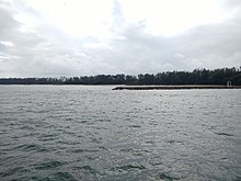
The Muara Cut was initiated in the 1960s to provide access to Muara Port. [4] This was done by excavating and then dredging a 10m channel at the narrowest point of Tanjong Pelumpong which converted Tanjong Pelumpong from a spit to an island. A minke whale was beached on the island in 2003. [7]
There are plans to further deepen the Muara cut to a depth of 16m [8] in order to facilitate the expansion of Muara Port to Pulau Muara Besar. [9] The dredged sand will be used for land reclamation on Pulau Muara Besar for the proposed port construction and extension.
Brunei–Muara District or simply known as Brunei–Muara, is the smallest as well as the most populated district in Brunei. It has an area of 571 square kilometres (220 sq mi) and the population of 318,530 as of 2021. The district is also home to its administrative centre is Bandar Seri Begawan, as well as the Brunei International Airport and Muara Port, the country's only international airport and deep-water port respectively. The Brunei River flows within this district and is home to Kampong Ayer. As the administrative center of Brunei is located in the district, it remains the most developed in the country with the most up-to-date infrastructure, despite not being the center of Brunei's main economic activity.

Sibu Island is an island group in Mersing District, Johor, Malaysia.
Kuraman Island, alternative name Keraman Island, is an outlying island in the Federal Territory of Labuan, Malaysia located on the northern mouth of Brunei Bay. It is sparsely populated and is popular with expatriates, divers and those who travel between Labuan and Brunei. Its land area measures 147 hectares. Together with the much smaller islands Pulau Rusukan Besar and Pulau Rusukan Kecil it forms the Labuan Marine Park.

Muara or officially known as Muara Town, is a port town in Brunei-Muara District, Brunei, about 28 kilometres (17 mi) from the capital Bandar Seri Begawan. The population of the town proper was 2,102 in 2016. It is home to Muara Port, the country's primary deep water port.

Sungai Tujoh, is the westernmost point of Brunei. It is located in the Belait district.
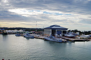
Mukim Serasa is a mukim in Brunei-Muara District, Brunei. The population was 16,173 in 2016. The mukim encompasses Muara Town, home to Muara Port, the country's only deepwater port.

Mulaut Abattoir Sdn Bhd is a slaughterhouse located in Brunei. It processes and supplies halal meat and slaughtering facilities to the public. It also supplies meat to Royal Brunei Airlines catering operations.

Sarmi Regency is one of the regencies (kabupaten) in Papua Province of Indonesia. It was formed from the western districts which had until then been part of Jayapura Regency with effect from 12 November 2002. It covers an area of 18,034.0 km2, and had a population of 32,971 at the 2010 Census and 41,515 at the 2020 Census; the official estimate as at mid 2023 was 42,680. The regency's administrative centre is at the town of Sarmi.

Kampong Serasa is a village in Brunei-Muara District, Brunei, near the port town Muara. The population was 3,200 in 2016. It is home to Serasa Ferry Terminal, the country's primary international ferry terminal.

Sultan Haji Omar 'Ali Saifuddien Bridge, also known as Temburong Bridge, is a dual-carriageway bridge in Brunei that spans across Brunei Bay, connecting the Bruneian mainland with its semi-exclave of Temburong. It is the longest bridge in Southeast Asia, at 30 kilometres (19 mi) long.

Transport in Brunei consists of air, land, and sea transport. Previously there was some rail transport in Brunei, but eventually most of it was closed down. Several public and commercial sector organizations are in charge of creating and overseeing these networks and infrastructures. The Ministry of Transport and Infocommunications (MTIC) is in charge of overseeing the maritime and aviation industries, as well as planning and regulating all kinds of land transportation.

Rail transport in Brunei highlights its role in industrial and wartime efforts, beginning with the Brooketon Colliery's 19th century coal railway to Muara's harbour, which aided steamship routes. Later, Brunei Shell Petroleum (BSP) built a line from Seria to Badas in the 1930s for water and pipeline transport, reactivated briefly by Australian forces in the Second World War. Today, Brunei LNG uses a rail system to transport equipment offshore, and plans for a Trans Borneo Railway aim to enhance trade by linking Brunei with neighbouring regions, underscoring rail’s lasting impact on Brunei's economy and connectivity.

Pulau Muara Besar Bridge is a dual-carriageway bridge which connects Pulau Muara Besar, an island on Brunei Bay, with the mainland of Brunei via Serasa in Brunei-Muara District. The bridge is 2,680 metres long and 23 metres wide. The construction began in 2015 and completed in May 2018; it was undertaken by China Harbour Engineering Company at a cost of B$260 million or US$204 million. The bridge is part of the road infrastructure that will serve the petrochemical refinery plant on the island, which is currently under construction, and is a Chinese foreign direct investment. At present, access to the bridge is restricted to authorised personnels of the project.

Muara Besar Island is an island in Mukim Serasa, Brunei-Muara District, Brunei. The island is essential for the Brunei–China relations due to its part in the Chinese Belt and Road Initiative. It can be noted that the island may be referred to Muara Island in older works.

Muara Beach is a beach in Muara, Mukim Serasa, Brunei-Muara District, Brunei. The beach used to stretch up to Pelumpong Spit, before they were cut apart in order to make way for easy access to Muara Port in the 1960s. The beach is located at an estimated distance of 27 km from Bandar Seri Begawan, and 3 km from Muara Port.

Cermin Island is an islet at the mouth of Brunei River in the Mukim Kota Batu, Brunei-Muara District, Brunei. During the Brunei Civil War, a battle unfolded on the island and it's sometimes referred to as the Peperangan Pulau Cermin. A proposal for an 5 hectares protection status to be implemented on the island. The island is home to sundry vegetation and swamp forests.

Berambang Island is an island at the southern bank of the Brunei River in the Mukim Kota Batu, Brunei-Muara District, Brunei. The island was formerly named Buang Tawer during The Brooke Era from 1841 until 1941. The mausoleum of the 9th Sultan of Brunei, Sultan Muhammad Hassan is located on the island, near Kampong Sungai Bunga.