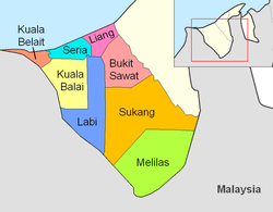
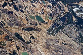
Mukim Seria is a mukim in Belait District, Brunei. It has an area of 169 square kilometres (65 sq mi); the population was 21,214 in 2016. The mukim encompasses Seria, one of the only two towns in the district. It is home to the oil and gas industry of the country.

Mukim Kuala Belait is a mukim in Belait District, Brunei. The population was 31,308 in 2016. The mukim encompasses Kuala Belait, the administrative town of the district.

Mukim Bukit Sawat is a mukim in Belait District, Brunei. It had a population of 794 in 2016.

Mukim Mentiri is a mukim in Brunei-Muara District, Brunei. The population was 30,192 in 2016.

Mukim Kianggeh is a mukim in Brunei-Muara District, Brunei. The population was 8,228 in 2016. The mukim encompasses Pusat Bandar, the city centre of the capital Bandar Seri Begawan.

Mukim Kilanas is a mukim in Brunei-Muara District, Brunei. The population was 22,492 in 2016.

Mukim Lumapas is a mukim in Brunei-Muara District, Brunei. It has an area of 62.10 square kilometres (23.98 sq mi); the population was 7,756 in 2016.

Mukim Pengkalan Batu is a mukim in Brunei-Muara District, Brunei. The population was 14,492 in 2016.

Mukim Peramu is a mukim in Brunei-Muara District, Brunei. It is located within Kampong Ayer, the historical stilt settlements on the Brunei River in the capital Bandar Seri Begawan. The population was 1,111 in 2016.
Mukim Gadong 'A' is a mukim in Brunei-Muara District, Brunei. The population was 34,049 in 2016.
Mukim Gadong 'B' is a mukim in Brunei-Muara District. Brunei. The population was 33,637 in 2016.
Mukim Keriam is a mukim in Tutong District, Brunei. The population was 9,707 in 2016.
Mukim Telisai is a mukim in Tutong District, Brunei. The population was 10,095 in 2016.

Mukim Pekan Tutong is a mukim in Tutong District, Brunei. The population was 9,883 in 2021. It encompasses Pekan Tutong, the district's sole town and administrative centre.

Mukim Kuala Balai is a mukim in Belait District, Brunei. The population was 31 in 2016.

Mukim Sukang is a mukim in Belait District, Brunei. The population was 169 in 2016.
Kampong Batu Marang is a village within Mukim Mentiri in Brunei-Muara District, Brunei. The population was 870 in 2016.
STKRJ Tungku Area 1 is a public housing estate and village within Mukim Gadong 'A' in Brunei-Muara District, Brunei. The population was 1,332 in 2016. The postcode is BE2519. It is one of the estates for the Landless Indigenous Citizens' Housing Scheme, the public housing programme for the country's indigenous citizens.
STKRJ Tungku Area 2 is a public housing estate and village within Mukim Gadong 'A' in Brunei-Muara District, Brunei. The population was 1,862 in 2016. The postcode is BE2519. It is one of the estates for the Landless Indigenous Citizens' Housing Scheme, the public housing programme for the country's indigenous citizens.

Kampong Pancha Delima is a village in Brunei-Muara District, Brunei, and a neighbourhood in the capital Bandar Seri Begawan. The population was 1,562 in 2016. It is one of the villages within Mukim Berakas 'A'. The postcode is BB4513.