Kampong Serasa

Last updated

Serasa
Kampung Serasa
Kampong Serasa
Serasa Ferry Terminal, Bandar Seri Begawan, Brunei.JPG
Brunei location map.svg
Red pog.svg
Location in Brunei
Coordinates: 5°00′51″N115°03′30″E / 5.0143°N 115.0582°E / 5.0143; 115.0582
Country Brunei
District Brunei-Muara
Mukim Serasa
Population
 (2016) [1]
  Total3,200
Time zone UTC+8 (BNT)
Postcode
BT1728

Kampong Serasa is a village in Brunei-Muara District, Brunei, near the port town Muara. The population was 3,200 in 2016. [1] It is home to Serasa Ferry Terminal, the country's primary international ferry terminal.

Contents

Name

Serasa is thought to have been given its name by a group of migrant workers who arrived at one of the village's waterways. They took some of the pucuk gajus (cashew leaves) and pucuk pawas (sprouts) as side dishes when they stopped to rest and eat their prepared pais-paisan meals. They discovered the taste of the pucuk-pucuk to be serasa (fitted to their palates), after eating it. They settled there and gave the river the name Serasa. As these people originated from Indonesia's Sebatik Island, the town was briefly known as Kampong Sebatik. [2]

Geography

Kampong Serasa is located in the north-easternmost part of Brunei-Muara District. It is one of the villages within Mukim Serasa. It comprises the original village settlement and the public housing estate Kampong Perpindahan Serasa. It also encompasses Serasa Industrial Site, one of the dedicated industrial estates in the country. The village has the postcode BT1728. [3]

History

According to folktales, there are Muara inhabitants who reside in a community known as Kampong Dadap. These locals migrated around during the Japanese occupation, and some constructed homes and mosques in an area known as Biawak River (Sungai Biawak) along the banks of the river mouth. The mosque in the town of Biawak River sustained damage following the end of the Second World War. The name of Kampong Sungai Biawak was changed by the people to Kampong Masjid Lama in order to preserve memories. Residents have been relocated to Kampong Serasa, due to the port's expanding expansion. [4]

Economy

The Majlis Perundingan Kampung (MPK) generates goods from marine sources in accordance with the position of the village near to the landing spot of ships and fishing boats in an effort to help the Ministry of Home Affairs' ambition to achieve the 1K1P Program. Producing raw lumai tamban, lumai salted fish, lumai tamban snacks, tahai, lumai lekor crackers, and lumai fish crackers. The procurement of a cracker-making machine was made possible by a BND42,000 funding from the Brunei and Muara District Department. With the use of this equipment, MPK created up to 2,500 boxes of fish and shrimp crackers each month, depending on market demand. Assisting in advise and direction on product quality assurance and packaging are the Departments of Fisheries and Agriculture and Food. [5]

Demography

The residents of these villages are made up of various races and tribes such as the Malays, the Kedayan, the Chinese and others. [5]

Transportation

Water

Serasa Ferry Terminal is the main international ferry terminal in Brunei. It mainly serves passengers arriving from and departing to Labuan and Kota Kinabalu in Malaysia by sea. [6] The terminal recorded an annual average of 60,000 tourist arrivals from these destinations. [6]

Infrastructure

Serasa Beach Serasa Beach Recreational Park 20.05.2018.jpg
Serasa Beach

With the construction of the Temburong Bridge, which spans the Brunei Bay for approximately 30 kilometers, connecting Muara with Jalan Labu in the Temburong District and Jalan Utama Mentiri in the Serasa and Muara areas, development in those areas is accelerating rapidly. It is one of the biggest national projects and is anticipated to be finished in 2019. Also built, a connecting bridge of approximately 2.7 kilometers to Pulau Muara Besar, where the Hengyi Industries integrated Oil and Aromatic Refinery is now based, which is the single largest Foreign Direct Investment (FDI) in Brunei. [5]

Education

Places of interest

Related Research Articles

<span class="mw-page-title-main">Muara, Brunei</span> Town in Brunei

Muara Town or simply Muara is a port town in Brunei-Muara District, Brunei, about 28 kilometres (17 mi) from the capital Bandar Seri Begawan. The population of the town proper was 2,102 in 2016. It is home to Muara Port, the country's primary deep water port.

<span class="mw-page-title-main">Mukim Serasa</span> Mukim in Brunei

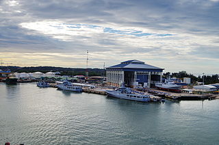
Mukim Serasa is a mukim in Brunei-Muara District, Brunei. The population was 16,173 in 2016. The mukim encompasses Muara Town, home to Muara Port, the country's only deepwater port.

<span class="mw-page-title-main">Mukim Kilanas</span> Mukim of Brunei

Mukim Kilanas is a mukim in Brunei-Muara District, Brunei. The population was 22,492 in 2016.

<span class="mw-page-title-main">Mukim Saba</span> Mukim of Brunei

Mukim Saba is a mukim in Brunei-Muara District, Brunei. It is part of Kampong Ayer, the traditional stilted settlements on the Brunei River in the capital Bandar Seri Begawan. The population was 1,000 in 2016. It encompasses the village of Kampong Saba.

<span class="mw-page-title-main">Mukim Tamoi</span> Mukim of Brunei

Mukim Tamoi is a mukim in Brunei-Muara District, Brunei. It is part of Kampong Ayer, the traditional stilt settlements on the Brunei River in the country's capital Bandar Seri Begawan. The population was 1,389 in 2016.

<span class="mw-page-title-main">Mukim Amo</span> Mukim of Brunei

Mukim Amo is a mukim in Temburong District, Brunei. It has an area of 542 square kilometres (209 sq mi); the population was 2,144 in 2016.

<span class="mw-page-title-main">Mukim Bangar</span> Mukim of Brunei

Mukim Bangar is a mukim in Temburong District, Brunei. It has a total area of 113 square kilometres (44 sq mi); the population was 2,449 in 2016. The mukim encompasses Bangar, the district's sole town and administrative centre.

<span class="mw-page-title-main">Kampong Mentiri</span> Village in Brunei

Kampong Mentiri or simply known as Mentiri, is a village in the north-east of Brunei-Muara District, Brunei. It has an area of 322.29 hectares ; the population was 1,215 in 2016.

<span class="mw-page-title-main">Lambak Kanan</span> Public housing estate in Brunei

RPN Lambak Kanan, Kampong Perpindahan Lambak Kanan or simply Lambak Kanan is a public housing estate in Brunei-Muara District, Brunei, on the outskirts of the country's capital Bandar Seri Begawan. The total population was 19,833 in 2016. Established in 1986, it is the first estate for the National Housing Scheme, the public housing programme for the country's citizens.

<span class="mw-page-title-main">Kampong Kapok</span> Village in Brunei

Kampong Kapok is a village in the north-east of Brunei-Muara District, Brunei and has an area of 1,241.01 hectares ; the population was 2,791 in 2016.

<span class="mw-page-title-main">Kampong Tungku</span> Village in Brunei

Kampong Tungku is a village in Brunei-Muara District, Brunei, about 10 kilometres (6.2 mi) from the capital Bandar Seri Begawan. The population was 1,689 in 2016. It is one of the villages within Mukim Gadong 'A'. The postcode is BE2119.

<span class="mw-page-title-main">Kampong Kiarong</span> Village in Brunei

Kampong Kiarong or commonly known as Kiarong, is a village in Brunei-Muara District, Brunei, as well as a neighbourhood in the country's capital Bandar Seri Begawan. It has an area of 383.43 hectares ; the population was 4,530 in 2016.

Kampong Perpindahan Mata-Mata or simply known as Perpindahan Mata-Mata, is a public housing estate and designated village in Brunei-Muara District, Brunei, on the outskirts of the capital Bandar Seri Begawan. The population was 2,385 in 2016. It is one of the villages within Mukim Gadong 'B'. The postcode is BE1918.

<span class="mw-page-title-main">Kampong Bunut Perpindahan</span> Village of Brunei

Kampong Bunut Perpindahan or also known as Kampong Perpindahan Bunut, is a village in Brunei-Muara District, Brunei, as well as a neighbourhood in the capital Bandar Seri Begawan. The population was 1,707 in 2016. It is one of the villages within Mukim Kilanas. The postcode is BF1220.

<span class="mw-page-title-main">Kampong Pengiran Siraja Muda Delima Satu</span> Village in Brunei-Muara, Brunei

Kampong Pengiran Siraja Muda Delima Satu is a village in Brunei-Muara District, Brunei, and a neighbourhood in the capital Bandar Seri Begawan. The population was 2,354 in 2016. It is one of the villages within Mukim Berakas 'A'. The postcode is BB5113.

<span class="mw-page-title-main">Kampong Sabun</span> Village in Brunei

Kampong Sabun is a village in Brunei-Muara District, Brunei, near the port town Muara. The population was 412 in 2016. It is one of the villages within Mukim Serasa. The postcode is BT2128.

<span class="mw-page-title-main">Kampong Sungai Besar</span> Village in Brunei-Muara, Brunei

Kampong Sungai Besar or commonly known as Sungai Besar, is a village in the east of Brunei-Muara District, Brunei, near the mouth of the Brunei River with the Brunei Bay. The population was 2,039 in 2016.

<span class="mw-page-title-main">Kampong Pelambayan</span> Village in Brunei

Kampong Pelambayan or simply known as Pelambayan. is a village in Brunei-Muara District, Brunei. It is also a neighbourhood in the country's capital Bandar Seri Begawan. The population was 714 in 2016. It is one of the villages within Mukim Kota Batu. The postcode is BD2317.

Kampong Bokok or simply Bokok, is a village in Temburong District, Brunei, about 10 kilometres (6.2 mi) from the district town Bangar. The population was 182 in 2016. It is one of the villages within Mukim Bokok. The postcode is PE1951.

Kampong Labu Estate or simply known as Labu Estate, is a village in Temburong District, Brunei, about 16 kilometres (9.9 mi) from the district town Bangar. The population was 152 in 2016. It is one of the villages within Mukim Labu. The postcode is PB1151.

References

  1. 1 2 "Population and Housing Census Update Final Report 2016" (PDF). www.deps.gov.bn. Department of Statistics. December 2018. Retrieved 27 July 2021.
  2. Mohd Yunos, Rozan (2013). SEMINAR UNITED NATIONS GROUP OF EXPERTS ON GEOGRAPHICAL NAMES ASIA, SOUTHEAST DIVISION (PDF). p. 9.
  3. "Buku Poskod Edisi Kedua (Kemaskini 26 Disember 2018)" (PDF). post.gov.bn (in Malay). Brunei Postal Services Department. 26 December 2018. Retrieved 27 July 2021.
  4. "Kampung Masjid Lama, Pekan Muara, Sabun dan Pelumpong : Wujudkan semangat bekerjasama". Pelita Brunei. 16 May 2015. Retrieved 9 September 2023.
  5. 1 2 3 4 KOMPILASI RENCANA KNK 2018 (PDF) (in Malay). Kenali Negera Kitani. 2018. pp. 28–32.
  6. 1 2 ""Discover Muara" Promotion Provides Exposure to Tour Packages & Places of Interest in the Country". Brudirect.com. 3 March 2019. Retrieved 27 July 2021.
  7. "SenaraiMasjid - Masjid Kampong Perpindahan Serasa". www.kheu.gov.bn (in Malay). Retrieved 27 July 2021.

Commons-logo.svg Media related to Serasa at Wikimedia Commons