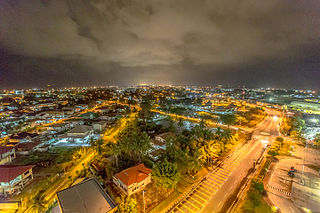
Bandar Seri Begawan (BSB) is the capital and largest city of Brunei. It is officially a municipal area with an area of 100.36 square kilometres (38.75 sq mi) and an estimated population of 100,700 as of 2007. It is part of Brunei–Muara District, the smallest yet most populous district which is home to over 70 per cent of the country's population. It is the country's largest urban centre and nominally the country's only city. The capital is home to Brunei's seat of government, as well as a commercial and cultural centre. It was formerly known as Brunei Town until it was renamed in 1970 in honour of Omar Ali Saifuddien III, the 28th Sultan of Brunei and the father of Sultan Hassanal Bolkiah.

Belait District or simply known as Belait, is the largest as well as the westernmost district in Brunei. It has an area of 2,727 square kilometres (1,053 sq mi) and the population of 65,531 as of 2021. The administrative town is Kuala Belait, located at the mouth of the 32 kilometres (20 mi) long Belait River. The district is commonly associated with the oil and gas industry of the country, mainly concentrated near the town of Seria.

Tutong District or simply known as Tutong, is the third largest and populated district in Brunei. It has an area of 1,166 square kilometres (450 sq mi) and the population of 47,210 as of 2021. The district is also home to its administrative centre is Tutong Town, as well as the Tutong River and Tasek Merimbun, the country's second longest river and the only ASEAN Heritage Parks in Brunei respectively.

Kuala Belait or officially the Kuala Belait Town, and colloquially referred to as KB, is the administrative town of Belait District, Brunei. The population of the town proper was 4,259 in 2016. Kuala Belait is officially a municipal area, as well as a village under the mukim of the same name. The town is located 85 kilometres (53 mi) west of the country's capital Bandar Seri Begawan, and 20 kilometres (12 mi) west of Seria, the district's other town. It is also in the westernmost part of country, near the mouth of the Belait River.

Tutong Town or simply known as Tutong, is a municipality town in Mukim Pekan Tutong Tutong District, Brunei. It is located about 40 kilometres (25 mi) from the country's capital Bandar Seri Begawan. It is the administrative centre of Tutong District.

Seria or officially known as Seria Town, is a town in Belait District, Brunei. It is located about 65 kilometres (40 mi) west from the country's capital Bandar Seri Begawan. The total population was 3,625 in 2016. It was where oil was first struck in Brunei in 1929 and has since become a centre for the country's oil and gas industry. The town's bazaar, officially opened on 19 September 1954, has few retail establishments, fresh food markets, supermarkets, banking services, tourist information centers, and a range of restaurants, including Malay, Chinese, Indian, Indonesian and Italian ones as well as outdoor dining in somewhat rustic settings. For processing documentation related to owning a car and hiring domestic helpers (amahs), government offices are located in Kuala Belait.

The Brunei Darussalam Scouts Association is the national Scouting and oldest non-governmental organisation in the country, established in 1933. It became a member of the World Organization of the Scout Movement (WOSM) in 1981. The association celebrate its founding on 1 July each year.
The administrative divisions of Brunei Darussalam mainly consist of daerah (districts), mukim (sub-districts), and kampung or kampong (villages). They are organised hierarchically in Brunei Darussalam, with daerah being the largest first level, and kampong the smallest third level.

Kampong Mumong, or simply known as Mumong, is a residential suburb of Kuala Belait, the principal town of Belait District, in Brunei Darussalam. It comprises the original Mumong settlement, as well as the Mumong public housing estate of the Landless Indigenous Citizens' Housing Scheme. However, it officially consists of two village sub-divisions, namely Mumong 'A' and Mumong 'B', which are under the mukim of Kuala Belait.

Kampong Sungai Teraban is a village in Belait District, Brunei, near the district's principal town Kuala Belait. It has an area of 22 square kilometres (8.5 sq mi); the population was 1,082 in 2016. It is one of the administrative villages within Mukim Kuala Belait.

Rasau is an area in Brunei. The area contains one of the many oil fields of Brunei, the Rasau Field, and a small village, Kampong Rasau, which has a population of 103.

Kampong Sungai Duhon is a village that is located within the town of Kuala Belait in Mukim Kuala Belait, Belait District of Brunei. The postcode is KA3131.

Mukim Kuala Balai is a mukim located in the Belait District of Brunei, known for its unique geographical setting. As of 2016, the population was recorded at just 31 residents. The village of Kampong Kuala Balai is situated in the upper Kumgang region of Belait, forming part of the Mukim Kuala Balai catchment area. It is located approximately 28 kilometres (17 mi) from Kuala Belait. However, Kampong Kuala Balai is currently uninhabited due to factors such as migration to other villages and employment opportunities elsewhere, leading to a decline in its once-thriving community. It is an early settlement of the Belait people, who formed the majority of its population, and it once served as the administrative center for the Belait District during traditional governance and British residency, while also being a prominent exporter of ambulong (sago) in its heyday.

Seri Kenangan Beach, also known as Tutong Beach, is a beach and spit in Kuala Tutong, Mukim Pekan Tutong, Tutong District. It is located at an estimated distance of 2 km west of Tutong town. It can also be noted that clay soils were found in the areas around the beach.

Kampong Lumut or commonly known as Lumut, is a coastal settlement in Belait District, Brunei Daurssalam, about 30 kilometres from the district town Kuala Belait. The total population was 11,273 in 2016.

Transport in Brunei consists of air, land, and sea transport. Previously there was some rail transport in Brunei, but eventually most of it was closed down. Several public and commercial sector organizations are in charge of creating and overseeing these networks and infrastructures. The Ministry of Transport and Infocommunications (MTIC) is in charge of overseeing the maritime and aviation industries, as well as planning and regulating all kinds of land transportation.

Kampong Danau, simply known as Danau, is a coastal village in Tutong District, Brunei, about 21 kilometres (13 mi) from the district town Pekan Tutong. It has a total area of 6.5023 square kilometres (2.5106 sq mi); the total population was 1,072 in 2016. It is one of the villages within Mukim Telisai.

The Belait River is a river in Belait District, Brunei. It is the longest of the four main rivers in the country.

Pengiran Abu Bakar bin Pengiran Umar was a Bruneian nobleman, civil servant, and politician who served as the fifth Speaker of the Legislative Council of Brunei. He held this position from 1 December 1974 until his retirement on 14 December 1981. Notably, he was the father-in-law of Princess Masna Bolkiah. His son, Pengiran Anak Abdul Aziz, became the prince consort of Princess Masna Bolkiah, who is the daughter of Sultan Omar Ali Saifuddien III.

Basir bin Taha was a Bruneian teacher who made significant contributions to education, welfare, and religion in Brunei. He played a pivotal role in raising awareness among Malay teachers about the importance of freeing the nation from colonialism and defending the sovereignty of both the monarchy and the people.


