Loretto, Minnesota

Last updated

Loretto
Motto: 
A Place to Call Home
Hennepin County Minnesota Incorporated and Unincorporated areas Loretto Highlighted.svg
Location of Loretto
within Hennepin County, Minnesota
Coordinates: 45°3′14″N93°38′4″W / 45.05389°N 93.63444°W / 45.05389; -93.63444
Country United States
State Minnesota
County Hennepin
Founded1886
Incorporated 1940
Government
   Mayor Kent Koch
Area
[1]
   City 0.26 sq mi (0.67 km2)
  Land0.26 sq mi (0.67 km2)
  Water0.00 sq mi (0.00 km2)
Elevation
1,014 ft (309 m)
Population
 (2020)
   City 646
  Density2,503.88/sq mi (966.28/km2)
   Metro
3,279,833
Time zone UTC-6 (Central)
  Summer (DST) UTC-5 (Central)
ZIP code
55357 [2]
Area code 763
FIPS code 27-38222 [3]
GNIS feature ID0647188 [4]
Website www.ci.loretto.mn.us

Loretto is a small rural city in Hennepin County, Minnesota, United States. The population was 650 at the 2010 census. [5]

Contents

Geography

According to the United States Census Bureau, the city has a total area of 0.29 square miles (0.75 km2), all land. [6] County Roads 11 and 19 are two of the main routes. Nearby places include Medina, Maple Plain, Independence, Greenfield, and Corcoran.

History

Loretto was founded in 1886, and settled by German and Dutch immigrants. Loretto derives its name from two sources: the Jesuit mission, Notre-Dame de la Jeune Lorette, located on the east bank of the Saint Charles River, about eight miles northwest of Quebec City in Canada, known as Lorette, which served as a refuge for Huron Indian refugees, and the village of Loretto, Kentucky, where the Sisters of Loretto at the Foot of the Cross were founded in 1812. The original inspiration for the name stems from Loreto, a small town in Italy, celebrated for its pilgrimage shrine.

The city was incorporated in 1940. The first mayor was Albert Van Beusekom.

In 2010, Loretto elected Kent Koch as its mayor. Koch was the starting second baseman on the St. Cloud State University baseball team, and was believed to be the only college student in the country who was also a mayor. [7]

Demographics

Historical population
CensusPop.Note
1950 179
1960 27151.4%
1970 34025.5%
1980 297−12.6%
1990 40436.0%
2000 57041.1%
2010 65014.0%
2020 646−0.6%
U.S. Decennial Census [8]

2010 census

As of the census [9] of 2010, there were 650 people, 269 households, and 168 families living in the city. The population density was 2,241.4 inhabitants per square mile (865.4/km2). There were 278 housing units at an average density of 958.6 per square mile (370.1/km2). The racial makeup of the city was 98.6% White, 0.3% African American, 0.3% from other races, and 0.8% from two or more races. Hispanic or Latino of any race were 1.2% of the population.

There were 269 households, of which 34.6% had children under the age of 18 living with them, 53.2% were married couples living together, 7.8% had a female householder with no husband present, 1.5% had a male householder with no wife present, and 37.5% were non-families. 30.9% of all households were made up of individuals, and 11.6% had someone living alone who was 65 years of age or older. The average household size was 2.42 and the average family size was 3.10.

The median age in the city was 39.9 years. 24.6% of residents were under the age of 18; 7.4% were between the ages of 18 and 24; 25.5% were from 25 to 44; 30.2% were from 45 to 64; and 12.2% were 65 years of age or older. The gender makeup of the city was 50.3% male and 49.7% female.

2000 census

As of the census [3] of 2000, there were 570 people, 225 households, and 146 families living in the city. The population density was 1,948.7 inhabitants per square mile (752.4/km2). There were 228 housing units at an average density of 779.5 per square mile (301.0/km2). The racial makeup of the city was 98.95% White, 0.53% Native American, and 0.53% from two or more races. Hispanic or Latino of any race were 0.18% of the population. 56.7% were of German, 7.6% Irish and 6.2% Norwegian ancestry according to Census 2000.

There were 225 households, out of which 38.7% had children under the age of 18 living with them, 60.4% were married couples living together, 4.9% had a female householder with no husband present, and 34.7% were non-families. 27.6% of all households were made up of individuals, and 9.3% had someone living alone who was 65 years of age or older. The average household size was 2.53 and the average family size was 3.22.

In the city, the population was spread out, with 29.3% under the age of 18, 7.5% from 18 to 24, 33.7% from 25 to 44, 18.8% from 45 to 64, and 10.7% who were 65 years of age or older. The median age was 35 years. For every 100 females, there were 107.3 males. For every 100 females age 18 and over, there were 102.5 males.

The median income for a household in the city was $54,375, and the median income for a family was $71,944. Males had a median income of $50,208 versus $32,321 for females. The per capita income for the city was $27,443. About 0.7% of families and 1.6% of the population were below the poverty line, including none of those under age 18 and 8.2% of those age 65 or over.

Related Research Articles

<span class="mw-page-title-main">Blades, Delaware</span> Town in Delaware, United States

Blades is a town in Sussex County, Delaware, United States. As of the 2010 census, the town population was 1,241, a 29.8% increase over the previous decade. It is part of the Salisbury, Maryland-Delaware Metropolitan Statistical Area.

<span class="mw-page-title-main">Wright, Florida</span> Census-designated place in Florida

Wright is a census-designated place (CDP) in Okaloosa County, Florida, United States. The population was 23,127 at the 2010 United States Census. It is part of the Fort Walton Beach–Crestview–Destin Metropolitan Statistical Area.

<span class="mw-page-title-main">Burnham, Illinois</span> Village in Illinois, United States

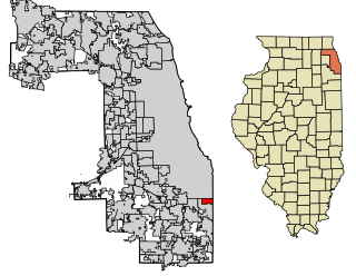
Burnham is a village in Cook County, Illinois, United States. The population was 4,046 at the 2020 census. The ZIP code is 60633.

<span class="mw-page-title-main">Loretto, Kentucky</span> City in Kentucky, United States

Loretto is a home rule-class city in Marion County, Kentucky, United States. The population was 723 at the 2020 census.

<span class="mw-page-title-main">Hessmer, Louisiana</span> Village in Louisiana, United States

Hessmer is a village in Avoyelles Parish, Louisiana, United States. The population was 802 at the 2010 census.

<span class="mw-page-title-main">Andover, Maine</span> Town in the state of Maine, United States

Andover is a town in Oxford County, Maine, United States. The population was 752 at the 2020 census. Set among mountains and crossed by the Appalachian Trail, Andover is home to the Lovejoy Covered Bridge and was the site of the Andover Earth Station.

<span class="mw-page-title-main">Harrisville Township, Michigan</span> Civil township in Michigan, United States

Harrisville Township is a civil township of Alcona County in the U.S. state of Michigan. The population was 1,307 at the 2020 census. Harrisville Township surrounds the city of Harrisville, but the two are administered autonomously.

<span class="mw-page-title-main">Chase Township, Michigan</span> Civil township in Michigan, United States

Chase Township is a civil township of Lake County in the U.S. state of Michigan. The population was 1,194 at the 2000 census.

<span class="mw-page-title-main">Corcoran, Minnesota</span> City in Minnesota, United States

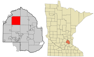
Corcoran is a rural city in Hennepin County, Minnesota, United States. The population was 5,379 at the 2010 census.

<span class="mw-page-title-main">Medina, Minnesota</span> City in Minnesota, United States

Medina is a city in Hennepin County, Minnesota, United States. An outer edge suburb of Minneapolis–Saint Paul, the city has a primarily rural character, with agricultural lands and natural preservation areas. Medina is home to the corporate headquarters of Polaris Inc., an automotive manufacturer that produces items such as all-terrain vehicles and snowmobiles.

<span class="mw-page-title-main">Willard, Ohio</span> City in Ohio, United States

Willard is a city in southwestern Huron County, Ohio, United States, approximately 14 miles (23 km) southwest of Norwalk. The population was 6,197 at the 2020 census.

<span class="mw-page-title-main">Tipton, Pennsylvania</span> Census-designated place in Pennsylvania, United States

Tipton is a census-designated place (CDP) in Antis Township, Blair County, Pennsylvania, United States. The population was 1,083 at the 2010 census. It was a stop on the former Pennsylvania Railroad Main Line between Tyrone and Altoona.

<span class="mw-page-title-main">Loretto, Pennsylvania</span> Borough in Pennsylvania, United States

Loretto is a borough in Cambria County, Pennsylvania, United States. As of the 2010 census it had a population of 1,302. Like the rest of Cambria County, it is part of the Johnstown, Pennsylvania Metropolitan Statistical Area. Loretto is the home of Saint Francis University.

<span class="mw-page-title-main">Deer Lake, Pennsylvania</span> Borough in Pennsylvania, United States

Deer Lake is a borough in Schuylkill County, Pennsylvania. The population was 670 at the 2020 census. The mayor of the borough is Larry Kozlowski.

<span class="mw-page-title-main">Loretto, Tennessee</span> City in Tennessee, United States

Loretto is a city in Lawrence County, Tennessee, United States. The population was 1,714 at the 2010 census, and 1,739 at the 2020 census.

<span class="mw-page-title-main">War, West Virginia</span> City in West Virginia, United States

War is a city in McDowell County, West Virginia, United States. The population was 690 at the 2020 census. War was incorporated in 1920 by the Circuit Court of McDowell County. Its name is derived from War Creek, whose confluence with Dry Fork is located within the city. War is the only place in the United States with this name. War was formerly known as Miner's City. It is also known for being a setting in the movie October Sky; as writer Homer Hickam's Big Creek High School.

<span class="mw-page-title-main">Bancroft, West Virginia</span> Town in West Virginia, United States

Bancroft is a town in Putnam County, West Virginia, United States, along the Kanawha River. The population was 389 at the 2020 census. It is part of the Huntington–Ashland metropolitan area.

<span class="mw-page-title-main">Lewiston, Wisconsin</span> Town in Wisconsin, United States

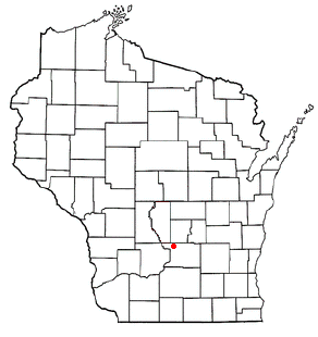
Lewiston is a town in Columbia County, Wisconsin, United States. The population was 1,187 at the 2000 census.

<span class="mw-page-title-main">Price, Wisconsin</span> Town in Wisconsin, United States

Price is a town in Langlade County, Wisconsin, United States. The population was 228 at the 2010 census. The unincorporated communities of Bryant and Sherry Junction and the ghost town of Kent are located in the town. The Bryant post office covers the entire town.

Castile is a village in Wyoming County, New York, United States. The population was 1,015 at the 2010 census.

References

  1. "2020 U.S. Gazetteer Files". United States Census Bureau. Retrieved July 24, 2022.
  2. "Loretto MN ZIP Code". zipdatamaps.com. 2024. Retrieved February 5, 2024.
  3. 1 2 "U.S. Census website". United States Census Bureau . Retrieved January 31, 2008.
  4. "US Board on Geographic Names". United States Geological Survey. October 25, 2007. Retrieved January 31, 2008.
  5. "2010 Census Redistricting Data (Public Law 94-171) Summary File". American FactFinder. U.S. Census Bureau, 2010 Census. Retrieved April 23, 2011.[ dead link ]
  6. "US Gazetteer files 2010". United States Census Bureau. Archived from the original on July 2, 2012. Retrieved November 13, 2012.
  7. Pennington, Bill. St. Cloud State Second Baseman Takes Reins of His Hometown. New York Times, 2011-04-23.
  8. "Census of Population and Housing". Census.gov. Retrieved June 4, 2015.
  9. "U.S. Census website". United States Census Bureau . Retrieved November 13, 2012.

45°03′17″N93°38′08″W / 45.05472°N 93.63556°W / 45.05472; -93.63556